Eritrea Technology and Resource Assessment Page

by Robert Van Buskirk, Ph.D. ( Resume)

E-Mail in Eritrea Stove Efficiency Wind Energy Remote Sensing
Rainfall Maps Temperature Maps Red Sea Wind Maps Solar Radiation
Vegetation Maps Biomass Production Topography Work Schedule
Rainfall Estimation Met. Analyses & Updates Site Statistics RVB Resume

Table of Contents

Brief Introduction to Eritrea
E-mail in Eritrea
Summary/Update April 1998
Discussion Paper, December 1996.
History of Eritrea Email: a personal view, September 1998.
Email-Based Internet Access Project, Text, September 1998.
Wind Energy in Eritrea papers, comments, and work in progress.
Preliminary Wind Resource Assessment of Eritrea, August 1996
South Red Sea Wind Maps
Wind Resource Assessment of Eritrea: Preliminary results and status, June 1997
South Coast Wind Resource Evaluation Field Trip Report, April 1997
Stove Efficiency Research
Introduction/Background of Eritrean Mogogo Research
Electric Mogogo Simulation Study, October 1996
Iron-Plate Mogogo Efficiency: Experimental results, April 1998.

Miscellaneous Information Re: Other Energy Sources
Anadarko Oil Exploration Update 10-30-98
Anadarko Oil Exploration Update 01-28-99
U.S. Embassy Update October 97

Elevation Map of Eritrea

Population Density Map of Eritrea

Eritrea Remote Sensing Research
Methods for Remote Sensing of Biomass, Solar Radiation, and Rainfall in Eritrea.
    By Tamrat Woldu, University of Asmara, June 1997.

Eritrea Temperature Maps, September 1998
Description and Index of Temperature Maps
Technical Article on Temperature Map Production
Annual Average of Daily Maximum, Average, and Minimum, Temperatures.
Seasonal Averages:
Winter Average of Daily Maximum, Average, and Minimum, Temperatures.
Spring Average of Daily Maximum, Average, and Minimum, Temperatures.
Summer Average of Daily Maximum, Average, and Minimum, Temperatures.
Autumn Average of Daily Maximum, Average, and Minimum, Temperatures.

Meteorological Updates and Analyses
Meteorological Update, Keremti 1998.
Meteorological Update, November 1998.
Analysis of Temperature Gradients.

Eritrea Biomass Production Maps, July 1998
Index of Biomass Production Maps

Map of Eritrea Vegetation Zones, August 1998
Technical Description
Full-Country View
Central Eritrea

Eritrea Rainfall Mapping/Estimation, October 1998
Satellite-based Rainfall Estimation over Eritrea , by Nurahmed Mohammedberhan
Annual Average Rainfall Map
Seasonal Averages: Winter, Spring, Summer, Fall,
Technical note on future adjustments to rainfall maps.
New methods for Estimating Winter Rain in Eritrea.

Eritrea Solar Radiation Mapping
Description and Index of Solar Energy Resource Maps
Some Hourly Maps:
    November 1995: 9am, 10am, 11am, 12pm, 1pm, 2pm, 3pm.
Average Daily Radiation:
    Annual Average
    Winter Average
    Spring Average
    Summer Average
    Autumn Average

Future work: Work plan and schedule.


Description/Comments

This page is for publishing research reports, images, maps, and other information products that may be useful to Eritrea for its development. Key topics currently include: Eritrea Energy Resources and Research, Agroclimatology, Meteorology, and Appropriate Technology for Information Services (Email, Internet, Networked Information Systems). We hope to also soon include information sources on Geomorphology, Crop and Agricultural Modeling and Resources, and Environmental and Ecological Modeling.

This information has been prepared by Robert Van Buskirk. If you have any questions regarding some of this research, please feel free to email me at

All of this information has been produced on a purely volunteer basis and is copyrighted but free. But if you are receiving benefit from this information, it is only fair that you give something in return. If you are a student or volunteer, then simply a note of encouragement and thanks to the authors would be appreciated. If you are a business or a consultant and are using this information to help you in your paid work, then it is only fair that you provide financial support for these research efforts. We have a non-profit project (the Eritrea Technical Exchange) which provides support to these efforts. Any donations will go to assisting Eritrea's information network development, or toward equipment to assist these research efforts.

Also, please note that if you use any of this information in reports papers or other documents, you must cite the authors.

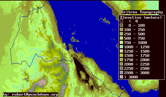
In addition, note that this page only presents images which summarize the available information products. There is a lot more information available if you have a specific need. Most maps also exist in a more accurate digital form that could easily be converted to a variety of information retrieval products. The digital data and custom information products can be obtained from the author if a specific request is made.

Contact Info:

Robert Van Buskirk
3217 College Ave.
Berkeley, CA 94705
U.S.A.
tel: 510-596-8869 (h)
email:

Last update by rvb January 11, 1999.