Eritrea Research Work Plan
Science Research in Solidarity with Eritrea
by Robert Van Buskirk,
Ph.D.
This page details plans and accomplishments with regards to providing
information and research services in support for Eritrea's development.
These tasks are proceding in distinct stages.
In Stage #1, we established a basic web site and started putting
documents, papers and basic images on the web. In addition we utilized
a PC-base program (the Image Display and Analysis program) to produce 16-color
images at resolutions of typically a few kilometers using a few years of
data. We produced data of basic climatic variables: temperature, rain,
wind, and solar radiation.
In Stage #2, we will be gradually increasing the accuracy, resolution,
interactivity, and sophistication of the geographic information models.
The activities will include the following:
-
Increasing resolution to approximately 1 km when possible
-
Increasing the accuracy of the mapping projections and decreasing location
errors
-
Expanding temporal coverage to include vegetation and rainfall from 1981
to present at 8 km resolution.
-
Including some current, real-time image data
-
Developing an interactive data retrieval interface
-
Developing an ecosystem model with priority given to biomass, woodfuel,
and rangeland production estimates.
-
Expanding color resolution to 255 colors for GIF images.
-
Developing more sophisticated models. These might include hydrology,
atmospheric motions, geomorphology, and/or agricultural and ecosystem production.
Please note that input, suggestions, and collaboration on this research
is much appreciated.
We first lists tasks completed, then the work in progress, and then
the tasks which are planned.
Stage #1 Tasks Completed
-
Temperature Maps (September '98)
-
Preliminary note on winter rain estimation
methods (September '98)
-
Red Sea Wind Maps (October '98)
-
Temperature Gradient Maps for Land-based
wind analysis (October '98)
-
Pre-Beta Version of Email-Based Internet Web Access Completed (November
'98)
-
Temperature Map Article Completed
(November '98)
-
Site Use Statistics Utility (November 14)
-
Solar Radiation Maps (November
'98)
-
Proposal for field testing
and promotion of iron mogogo plates
(January '99)
-
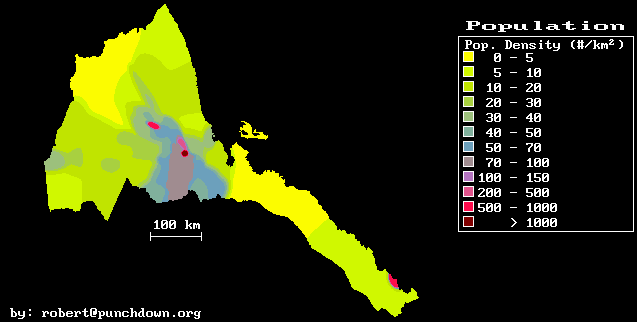
Population density map (January '99)
-
Atmospheric Temperature estimates (February '99)
-
Red Sea Surface Temperature (February
'99)
-
Montly Red Sea Wind Speeds (February '99)
-
Revised Article on Implementing
Internet in Eritrea (August '99)
Stage #2 Tasks Completed
-
Improved preprocessing of 1 km NDVI images.
-
Downloading of 1981 to 1994 data.
-
Improved preprocessing of topographic data.
-
Improved reprojection of NDVI images.
Work in Progress
-
Technical Support for Eritrean ISP's
-
Extended Normalized Difference Vegetation Archive
-
Improved and higher resolution topographic data
-
Automated collection and archiving of current meteosat images.
-
Development of interactive data display and retrieval utilities
-
Improved rainfall maps
-
Seasonal forecast analysis
-
Improved vegetation, biomass, wood, and rangeland production estimates
-
Geographic fuelwood supply and demand model
-
Support for improved efficiency mogogo field testing
Work suspended due to lack of time and resources
-
Email-Based Internet Access Services for Eritrean ISP's
-
Soil temperature modeling
-
Development of winter rain estimation methods
-
Geographic tools for energy development planning
-
Geographic cost maps for different energy supply types
Final Status of Stage # 1 Tasks (in order of priority)
-
Publicize web page and research (1 day, Sept 1998)[eg:
altavista,
hotbot,
infoseek,
etc]
-
Produced daily minimum and average temperature maps (1 week, Sept 1998,
finished
Sept 13)
-
Write temperature mapping article (1 week, Sept 1998,
finished
Nov 14)
-
Revise Summer Rain Estimate (2 days, Sept 1998) (near completion 6/99)
-
Complete revised monthly rain maps (1 week, Sept 1998) (in process)
-
Do rainfall mapping article and publish (only web version will be published)
-
Print special reports for Eritrean Agencies (1 week, Oct 1998)
-
Produce Solar Radiation Maps (2 weeks, Nov. 1998,
finished
Nov 23)
-
Write solar radiation mapping article (1 week, Nov. 1998)
-
Do specific rainfall maps for Eastern plains and escarpment (2 weeks, Dec
1998, partially completed)
-
Write eastern rain mapping article (suspended)
-
Reformat Tamrats report (1 day, Dec 1998)
-
Do detailed Red Sea Wind maps (1 week, Jan 1999,
finished
Oct 12, 1998)
-
Do Eritrea-wide wind maps (2 weeks, Jan 1999)(delayed)
-
Do wind mapping article/report (2 weeks, Jan 1999)(delayed)
-
Do wind analysis map/report (3 weeks, Feb 1999) (delayed)
-
Analyze verticle structure of Eritrean Atmosphere (2 weeks, Feb. 1999,
finished
Feb. 1999)
-
Produce interactive climate data retrieval tool (2 weeks, March 1999) (in
process)
-
Produce landscape modeling report (suspended)
-
Produce stream sediment modeling report (suspended)
-
Attempt remotely-sensed wind map (preliminary work completed, detailed
work suspended)
-
Produce rough hydrologic model of Eritrea (suspended)
-
Produce hydrologic data retrieval tool (suspended)
Plan and Status of Stage #2 Tasks
-
Improve preprocessing of NDVI images (May 1999, done)
-
Write-up improved preprocessing methods (July 1999)
-
Develop archive of preprocessed NDVI images at 1 km resolution 1993 to
1996 (June 1999)
-
Develop archive of 1981-present of 8 km resolution NDVI images (July 1999)
-
Develop archive of preprocessed Channel 1-5 images for at 1 km resolution
1993 to 1996 (Aug. 1999)
-
Develop archive of preprocessed Channel 1-5 images at 8 km resolution (Aug.
1999)
-
Develop NDVI and Channel 1-5 archives for California/Arizona study area
(May - Aug. 1999)
-
Collect rangeland and forest production data for California/Arizona study
area (May - Aug. 1999)
-
Improve preprocessing of Digital Elevation Model data and collect for both
Eritrea and CA/AZ study area (June 1999, done).
-
Write improved reprojection programs for AVHRR images (June 1999, done)
-
Improve Rainfall/NDVI correlation model (June 1999, done)
-
Produced new rainfall maps from improved model (July 1999)
-
Examine and document rangeland/forest production /NDVI correlations (August
1999).
-
Develop simple ecosystem production model (August 1999).
-
Produce ecosystem model calibrations and estimates (September 1999)
-
Produce improved temperature maps (September 1999)
-
Examine global NDVI/ Eritrea rainfall correlations (October 1999).
-
Produce public climate/ecosystem data retrieval site (October 1999).
-
Develop automated weather satellite image archiving and processing programs
(November 1999).
Last update September 1999 by rvb