Wind Speed:
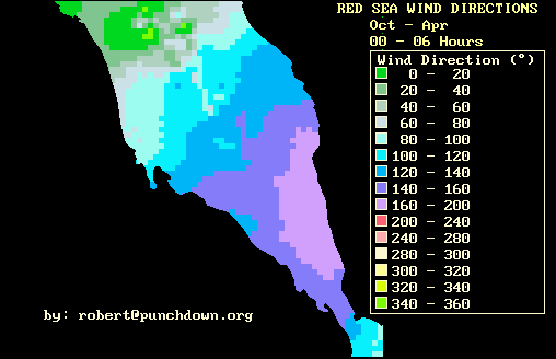
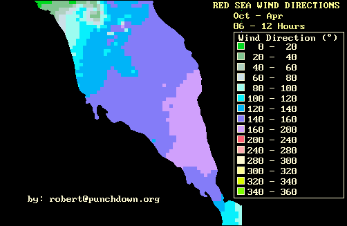
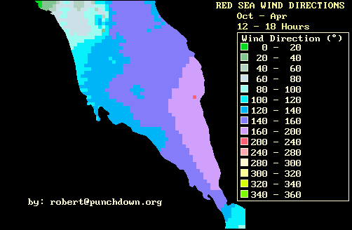
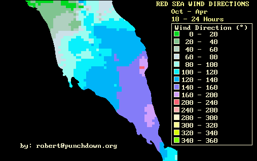
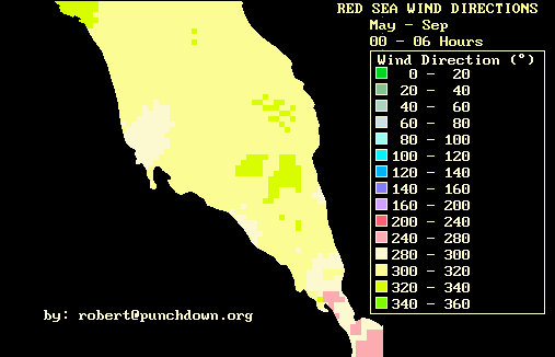
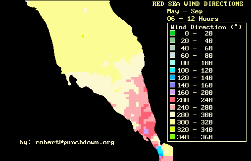
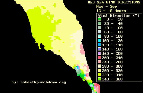
Wind Direction:
Annual Map
(Scatterometry)
Annual Map
(new COADS)
Annual Map (old COADS)
Monthly Maps:
(COADS):
(Scatterometry):
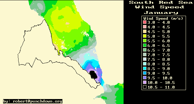
January
January
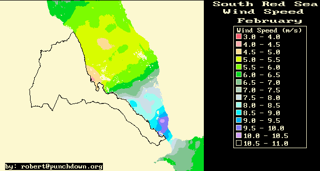
February
February
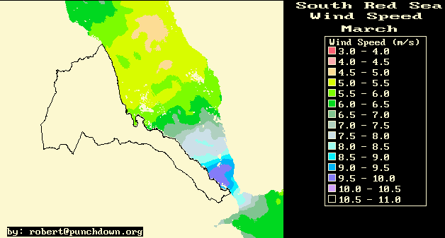
March
March
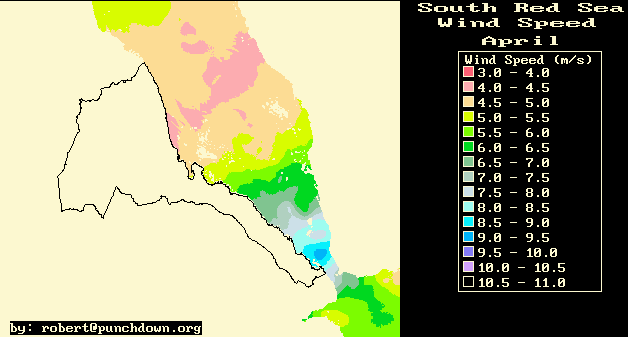
April
April
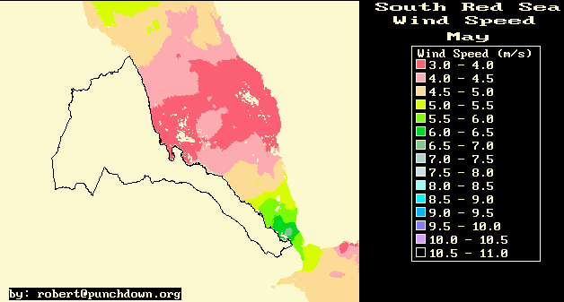
May
May
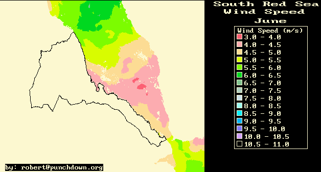
June
June
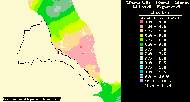
July
July
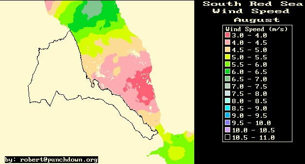
August
August
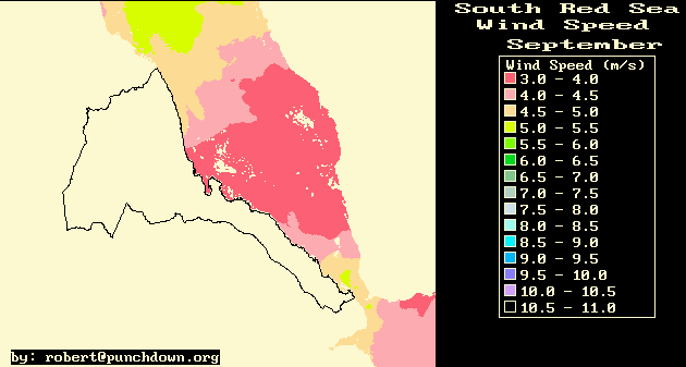
September
September
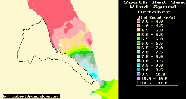
October
October
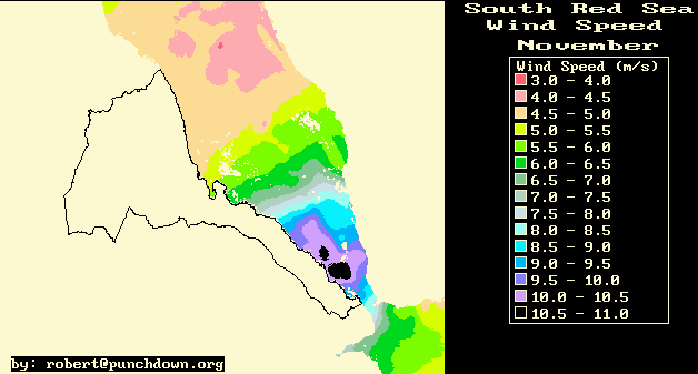
November
November
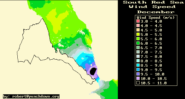
December
December
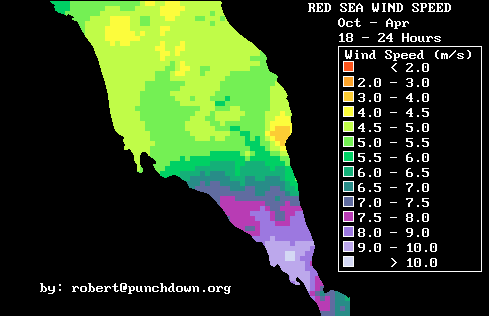
Seasonal Maps:
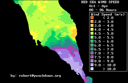
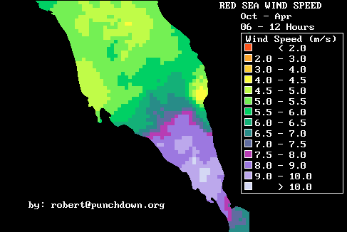
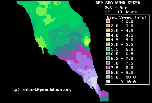
Oct - April
00:00-06:00
hrs
06:00-12:00
hrs
12:00-18:00
hrs
18:00-24:00
hrs
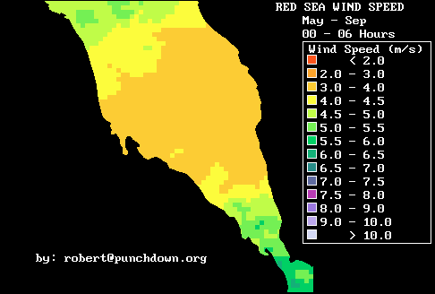
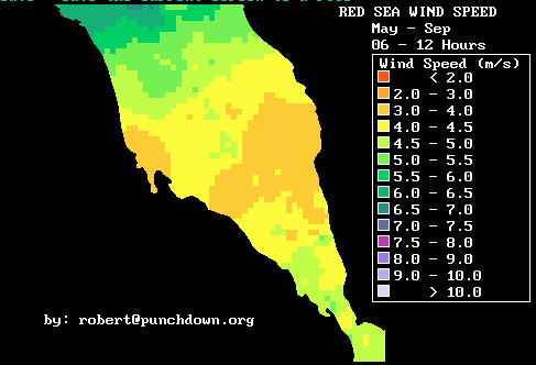
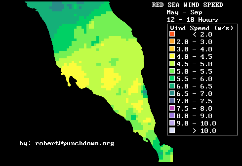
May - Sept
00:00-06:00
hrs
06:00-12:00
hrs
12:00-18:00
hrs
18:00-24:00
hrs
Seasonal Maps:
Oct - April
00:00-06:00
hrs
06:00-12:00
hrs
12:00-18:00
hrs
18:00-24:00
hrs
May - Sept
00:00-06:00
hrs
06:00-12:00
hrs
12:00-18:00
hrs
18:00-24:00
hrs
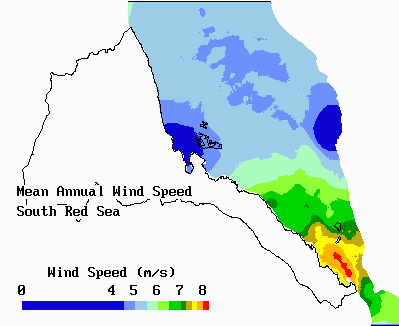
Wind Speed Data is useful for both energy resource and meteorological analyses. Wind energy may be the cheapest source of indigenous utility-scale electricty for Eritrea. A key issue for wind energy development is where it is best to locate the wind energy plants. Maps such as these assist in the geographic analysis of wind energy resources.
Multiple data sets are used because different data have different types of errors. The COADS data has low resolution outside of regular shipping lanes, so it does not characterize the East-West variation of the wind speeds well. Meanwhile the scatterometry data is calibrated with wave heights over open oceans, and it therefore underestimates winds in shallow or closes waters, or near land. The Scatterometry estimates are therefore about 1 m/s to 2 m/s lower than the COADS estimates, but they show the jet-like structure of the winds through Bab-al-Mandab better than the COADS data.
Wind speed data will be a key input for a national Eritrean meteorological
model. In Eritrea, meteorological modeling is needed to extrapolate
sparse ground measurements (of humidity, wind, rainfall, etc.) in order
to provide complete geographic coverage. Such meteorological models
will calculate the air motions in the lower 3-4 kilometers of the Eritrean
atmosphere. Wind patterns over the Red Sea will be an essential input
for calibrating and testing these models.
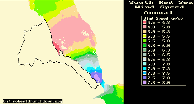
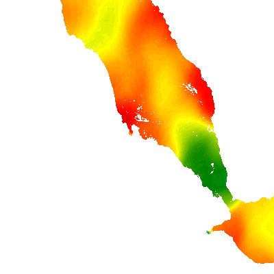
(Red = 2 m/s, Yellow = 4 m/s, Green = 6 m/s)
These maps were produced utilizing a binned, adaptive length scale, gaussian-weighted averaging of data from 1971-1993 of the Comprehensive Ocean-Atmosphere Data Set (COADS) or using the same method for the 1997-1999 Scatterometry data. More specifically, data from the data sets were binned into different temporal periods (usually four or six periods of the day for each seasonal or monthly map). A map was produced for each temporal bin, and the maps produced from the binned data were averaged to produce the monthly map. The data was binned this way in order to take out biases from uneven temporal sampling in the data.
To calculate averages, for each point on the map, two quantities are calculated: a gaussian weighted sum of values (wind speed in this case) and a sum of gaussian weights. The equation for the gaussian-weighted wind sum is as follows:
WIND-SUM = SUM OF (WS*EXP(-(R2/R02)))
where WS is the wind speed, R is the distance between the data point and the point of interest, and R0 is the averaging distance (or length scale). The second quantity is the sum of the weights:
WEIGHT-SUM = SUM OF (EXP(-(R2/R02)))
For the COADS data, the two quantities are calculated for progressivly larger R0 starting from R0= 10 kilometers to R0 = 150 kilomters. When the weight-sum is equal to a predetermined value (either 30, 40 or 50 depending on the degree of averaging desired), it is considered that there is enough data to calculate an average. The average is calculated as the ratio of the wind-sum and weight-sum for that location.
For the Scatterometry data a fixed R0 of 0.4 degrees was used.
For the wind direction, maps were first produced for the east-west
and north-south velocities, and the direction of the resulting vector wind
was taken as the mean wind direction.