| Introduction | Data/Images | Methods | Results |
Temperature information is crucial to a wide range of planning activities. It is necessary for analysing the agricultural potential of different areas. It is necessary for urban planning and building design. It is important for a wide range of environmental analyses and studies. And it is an essential element of any meteorological, climatological or agroclimatogical analysis.
Furthermore, if Eritrea is to plan its economic and development activities in a systematic and effective way, it needs to develop a comprehensive information system which can provide a wide range of meteorological, environmental, agricultural, and geologic information. This information is a necessary component to a comprehensive evaluation of national resources and development potential. An evalution of resources and conditions can and will be used to estimate the benefits and costs of different development and policy options.
A Vision of Things to Come
Temperature mapping, therefore, is just one component of what we hope is a comprehensive environmental and resource information system. The vision we present for such a comprehensive environmental and resource information system is as follows: Currently data is being collected on a wide range of resources and environmental parameters. This data usually comprises detailed measurements at selected locations or areas. For each such parameter or resource of interest, the relevant researchers should derive empirical locally calibrated relationships or models between remotely sensed information (e.g. Meteosat visible or infrared images, AVHRR visible or one of several bands of infrared, or Landsat images) and the specific measurements. Initially the calibration of the relationships is approximate. But in spite of this, satellite images are used to extrapolate the point measurements to the different areas of Eritrea's complex geography. This produces a collection of digital maps of environmental features and parameters of interest.
Meanwhile a user interface will be developed which allows users to extract the map information for any location in Eritrea given the location's geographic coordinates. This means that one can get complete (though approximate) environmental and resource information if one goes to a location (or if the location is already in a pre-compiled database) and finds the coordinates with a GPS (Global Positioning System). One then enters the relevant coordinates into the user interface, and it returns, elevation, monthly maximum and minimum temperature, mean monthly rainfall, mean monthly solar radiation, mean vegetative productivity, mean sediment production, mean run-off, soil temperature, wind speed, etc. This information then can be used to plan a wide range of potential development projects. Such projects may include vegetable farms, solar or wind power systems, agricultural management strategies, reservoirs and other water conservation structures, livestock production enhancements, etc.
The final stage of development of such an information system is to include a dynamic updating and calibration refinement capacity. This means the relationship between measured and remotely sensed data is continually updated and adjusted based on current measurements. Estimates are then refined to provide real-time predictions of dynamic parameters such as current rainfall, agricultural production, drought status, river flows, etc.
The maps were derived from Advanced Very High Resolution Radiometer (AVHRR) data obtained from public archives at the U.S. Geologic survey. We used AVHRR Channel 5 thermal infrared images and station elevation data to develop a two variable correlation with mean daily temperatures. The temperature data was obtained from the classic work on Eritrea meteorology and climate: Contributo all Climatologia Dell'Altopiano Etiopico, Regione Eritrea by Amilcare Fantoli, 1966.
The two tables below present the monthly means of daily maximum and daily minimum temperatures as reported by Fantoli.
| Station | Jan | Feb | Mar | Apr | May | Jun | Jul | Aug | Sep | Oct | Nov | Dec
| Akurdet | 32.8 | 34.5 | 36.5 | 39.2 | 40.4 |
39.0 | 35.5 | 33.7 | 36.0 | 37.8 | 36.6 | 34.6
| Aseb | 31.7 | 32.2 | 33.5 | 37.3 | 38.2
| 39.4 | 41.8 | 38.7 | 37.7 | 36.6 | 34.3 | 32.0
| Asmera | 22.7 | 23.7 | 24.9 | 25.1 | 24.9
| 25.2 | 21.8 | 22.0 | 23.2 | 21.5 | 21.3 | 21.9
| Barentu | 32.5 | 33.2 | 35.0 | 37.4 | 37.5
| 34.1 | 30.1 | 29.2 | 32.1 | 34.4 | 34.0 | 32.4
| Faghena | 18.2 | 19.2 | 20.5 | 23.0 | 26.1
| 29.0 | 27.0 | 27.3 | 27.6 | 23.7 | 20.4 | 18.4
| Ghinda | 23.2 | 23.8 | 26.5 | 30.0 | 32.9
| 35.5 | 37.8 | 37.3 | 34.4 | 29.3 | 27.0 | 24.4
| Keren | 28.7 | 29.9 | 31.6 | 33.8 | 34.8
| 33.3 | 28.6 | 27.3 | 30.5 | 31.6 | 29.9 | 29.0
| Mitsewa'e | 28.3 | 27.9 | 29.5 | 31.6 | 33.8
| 36.7 | 37.7 | 37.8 | 36.1 | 33.8 | 31.5 | 29.4
| Segheneyti | 20.7 | 23.0 | 23.6 | 25.2 | 24.9
| 25.6 | 23.0 | 23.0 | 24.2 | 23.1 | 21.6 | 19.8
| Teseney | 34.3 | 35.1 | 37.9 | 40.6 | 40.2
| 38.2 | 34.0 | 32.0 | 35.0 | 37.9 | 36.6 | 35.0
| |
| Station | Jan | Feb | Mar | Apr | May | Jun | Jul | Aug | Sep | Oct | Nov | Dec
| Akurdet | 18.0 | 18.6 | 19.3 | 22.5 |
24.8 | 24.8 | 22.5 | 21.0 | 22.6 | 24.0 | 21.8 | 19.6
| Aseb | 21.6 | 22 | 23.1 | 24.7 | 25.2
| 26.8 | 29.5 | 28.8 | 28.0 | 25.4 | 23.8 | 21.5
| Asmera | 7.2 | 8.1
| 9.7 | 11.1 | 12.1
| 12.2 | 11.8 | 11.8 | 10.8 | 9.8
| 8.5 | 7.5
| Barentu | 14.9 | 14.7 | 16.2 | 18.9
| 19.2 | 17.1 | 17.9 | 17.1 | 17.2 | 18.1 | 17.1 | 15.8
| Faghena | 11.2 | 11.6 | 12.7 | 14.4 | 16.6
| 19.7 | 18.4 | 18.4 | 18.2 | 15.0 | 13.1 | 11.9
| Ghinda | 15.0 | 16.0 | 15.8 | 17.0 | 19.4
| 25.8 | 27.4 | 22.4 | 23.4 | 19.4 | 18 | 17.1
| Keren | 12.4 | 12.8 | 15.2 | 16.9 | 17.7
| 16.7 | 16.9 | 16.3 | 15.0 | 15.5 | 14.9 | 13.5
| Mitsewa'e | 22.7 | 22.6 | 23.9 | 25.7
| 27.8 | 29.1 | 31.2 | 31.6 | 29.9 | 28.1 | 25.4 | 23.7
| Segheneyti | 6.8 | 7.6
| 8.6 | 10.6 | 11.4
| 11.7 | 11.4 | 11.1 | 13.2 | 9.5
| 7.6 | 6.4
| Teseney | 16.4 | 17.2 | 19.5 | 23.4 | 24.0
| 23.2 | 21.7 | 20.6 | 20.3 | 21.2 | 20.2 | 18.0
| |
To produce the temperature maps, we downloaded decadal Channel 5 AVHRR images from http://edcwww.cr.usgs.gov/landdaac/1KM/comp10d.html. We then read the two-byte binary data and converted it to a on-byte flat binary file, doing a simple rescaling of the pixel values by a factor of two. The program, rdat3.c is very simple and in the linked example is the version which converts two decadal images from December 1992.
The decadal Channel 5 images often contained some cloud contamination which obscured the infrared emissions from the ground. So it was often necessary to composite several images from the same month. We did this by taking the maximum of several images to compose the composite monthly Channel 5 image.
We then correlated this image data in combination with station elevation data with the monthly average of daily maximum and daily minimum temperatures. The relationship between Channel 5 pixel value, elevation, and temperature was linear. The relation has three parameters: (1) a constant term, (2) an Channel 5 coefficient, and (3) an elevation coefficient.
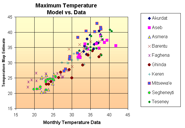
For maximum temperatures we used the same Channel 5 and elevation coefficient for all months, but varied the constant. The agreement between the resulting estimates derived from the linear relation, and the temperature data is shown in the following figure:
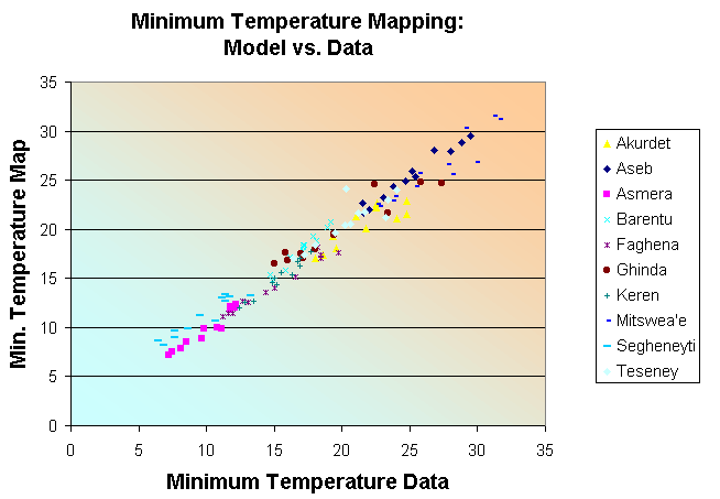
For estimating minimum temperatures we still had only the maximum Channel 5 images at our disposal (which presumably show infrared emissions from the ground during the day, not at night). We still conjectured that there was some relationship between day-time infrared emissions, elevation, and minimum temperatures. And based on this conjecture we calculated the correlation relationship. Though this time, we varied all three parameters for each month of the year.
Such a methodology is a bit questionable since we are using a three parameter function to fit to 10 different data points. And our data to parameter ratio is therefore quite low. But we observed that the parameters did not vary that much from month to month. And we hope that in the future we will be able to revisit the correlation analysis with both night-time infrared images and more temperature data.
We also found that during the summer months, the night-time temperatures were best correlated using a daytime infrared image from the winter months. This is because the daytime winter infrared images present a good delineation between the Red Sea air basin, and the inland air basin. At night, during the summer there is a significant temperature difference between stations in the two air basins. Therefore, an image which distinguishes between the two air basins will provide a good correlate.
The agreement between the correlation relationships and the data is presented in the following figure:
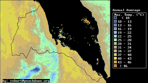
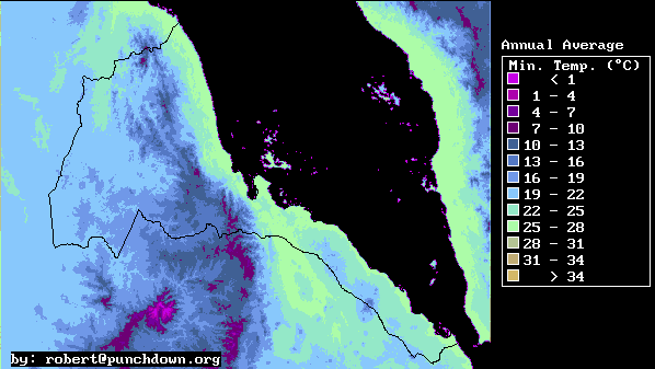
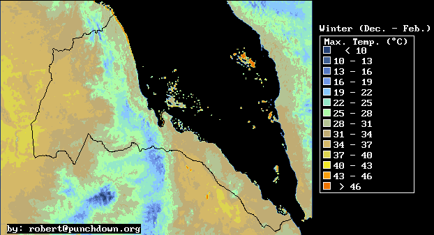
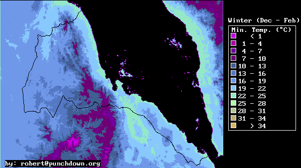
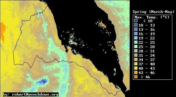
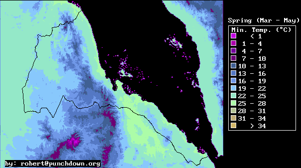
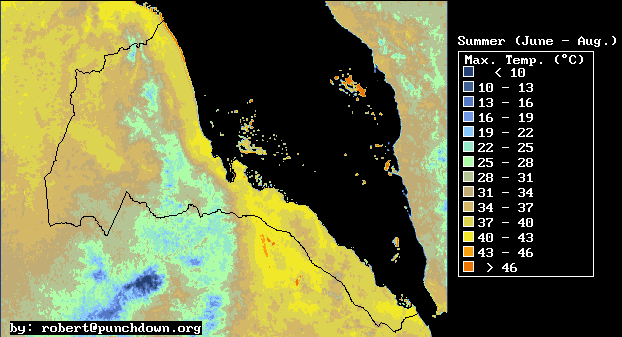
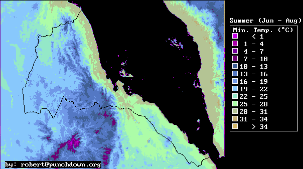
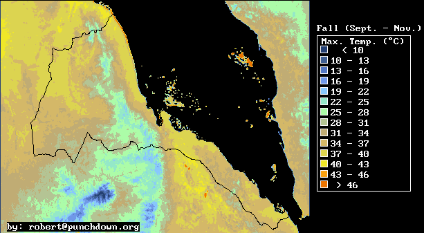
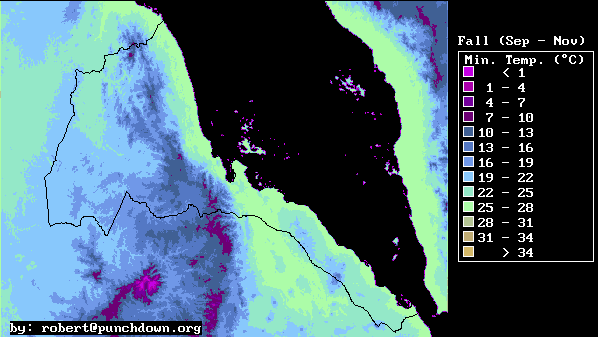
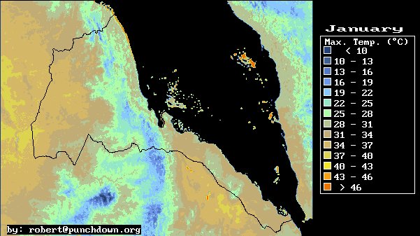
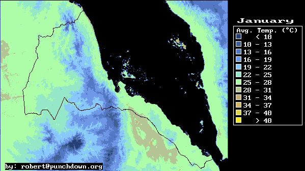
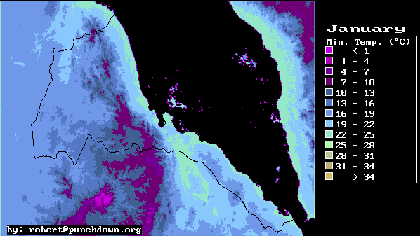
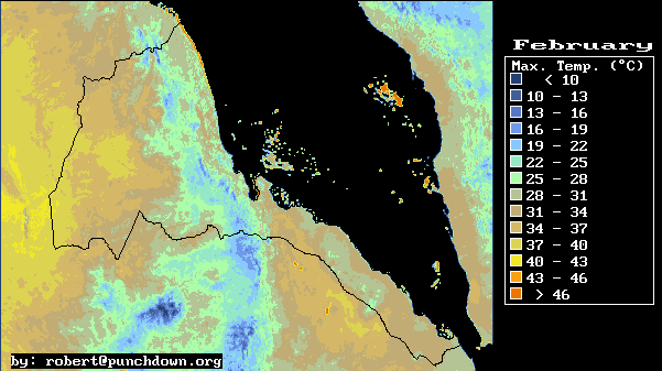
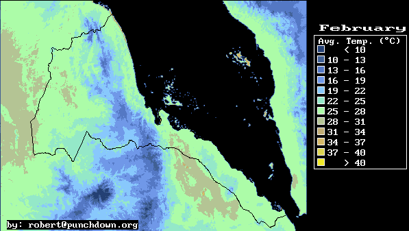
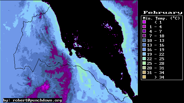
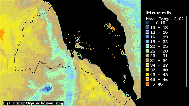
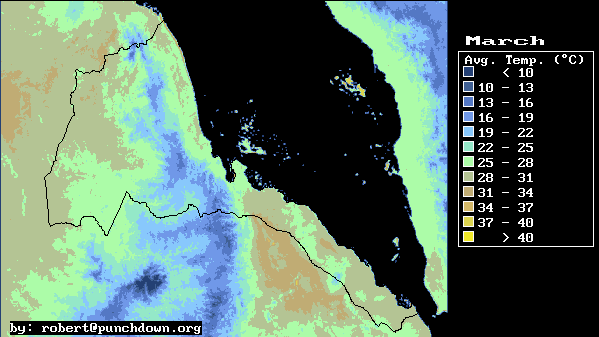
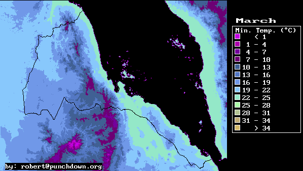
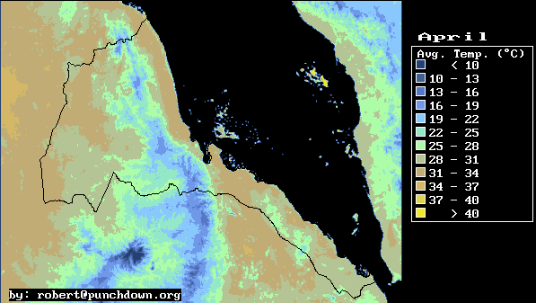
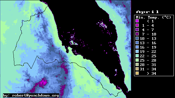
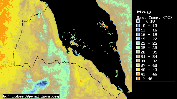
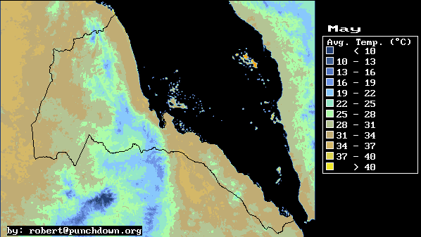
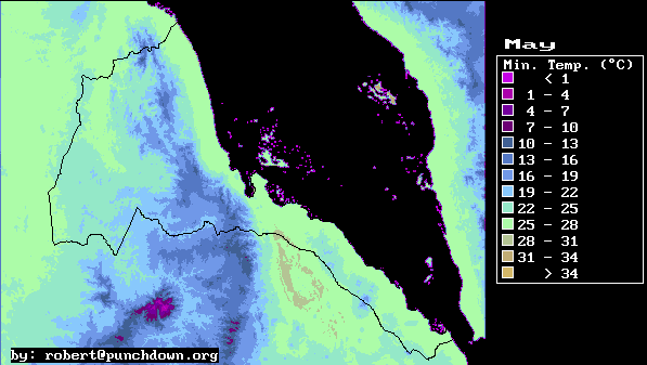
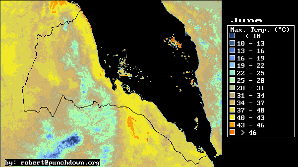
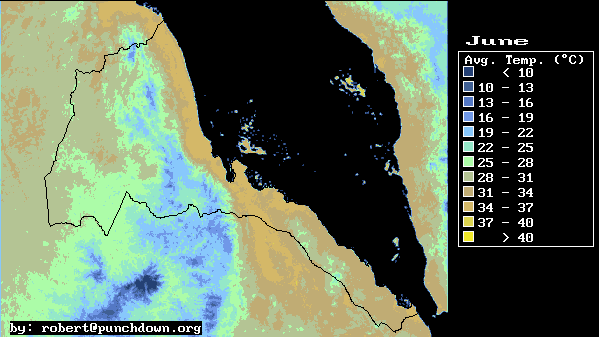
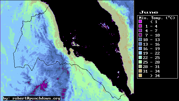
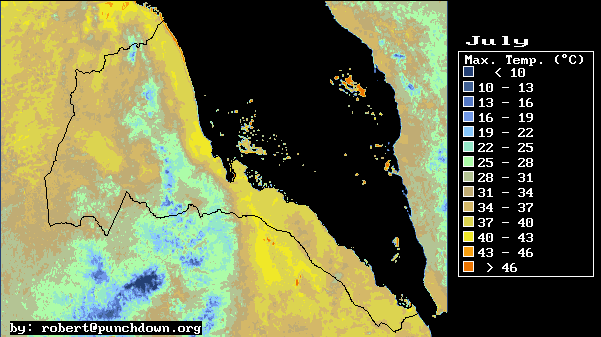
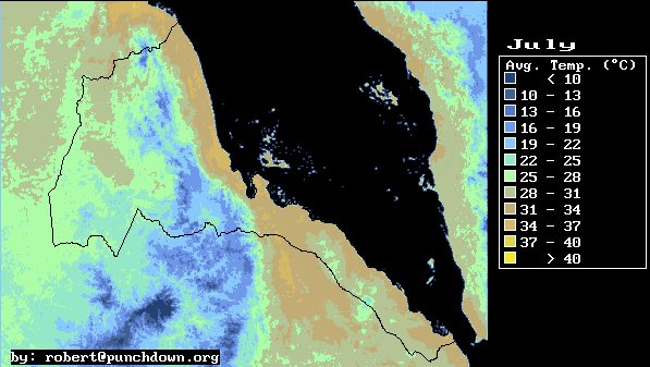
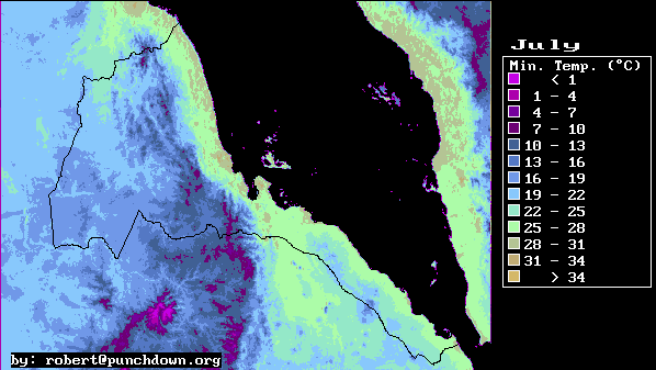
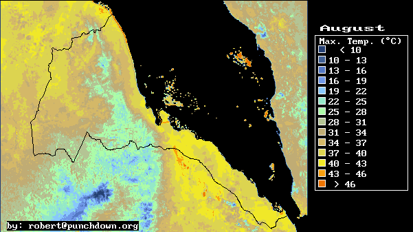
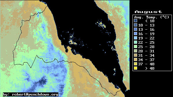
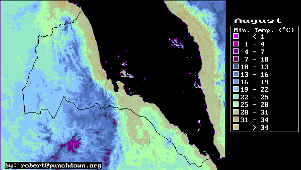
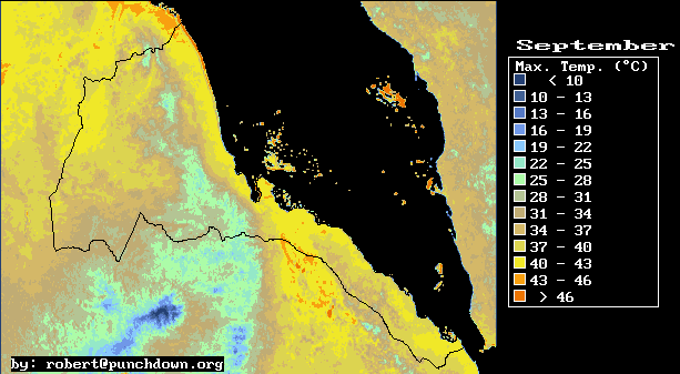
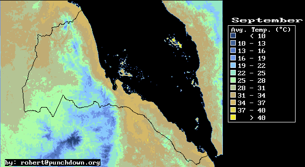
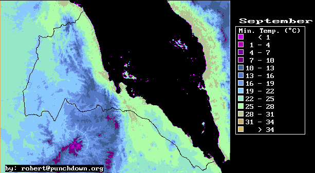
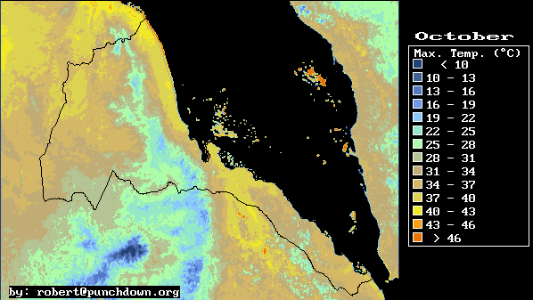
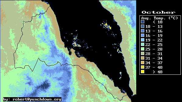
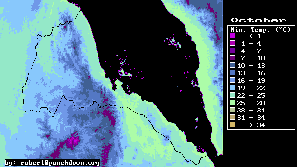
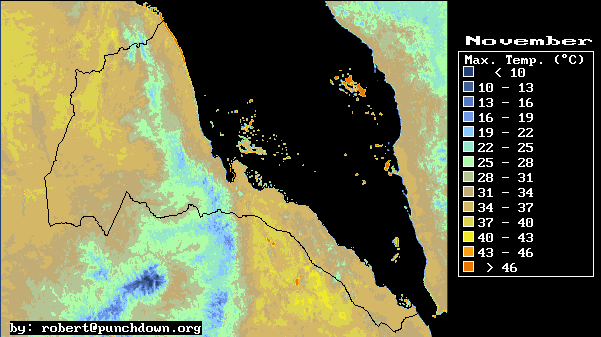
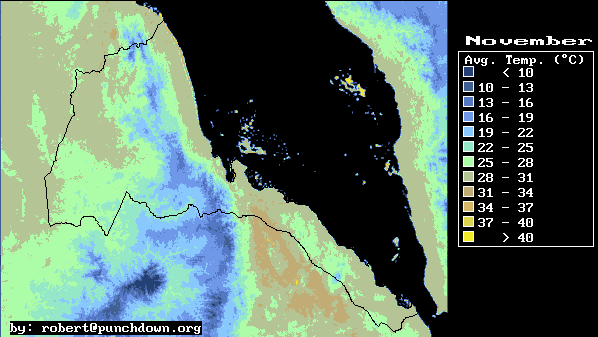
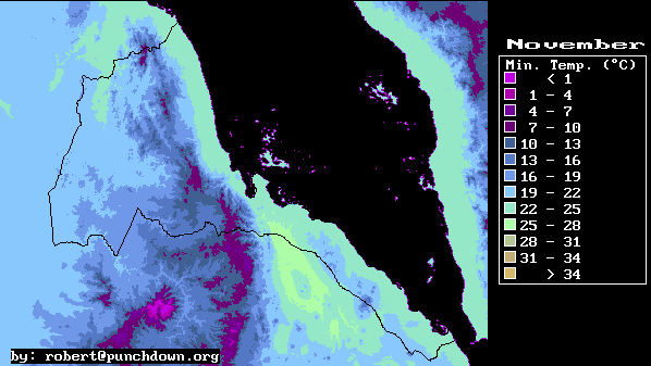
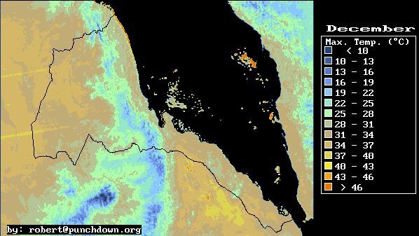
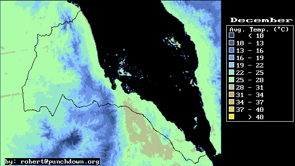
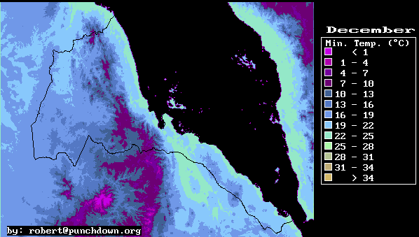
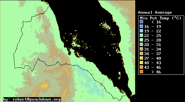
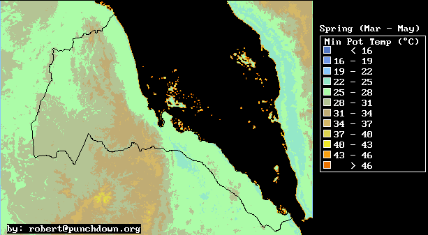
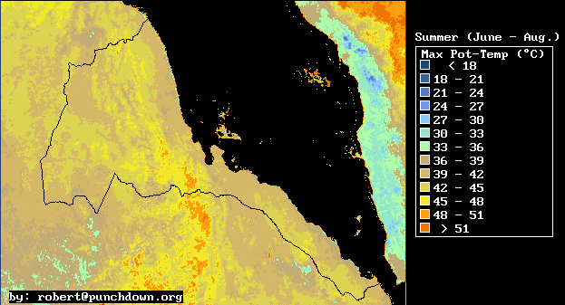
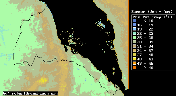
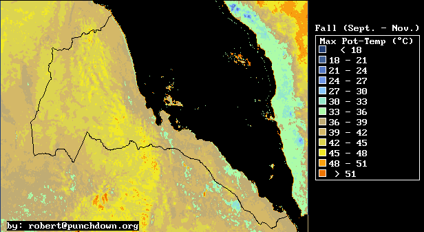
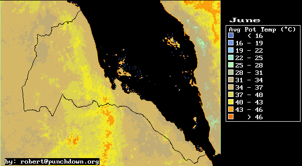
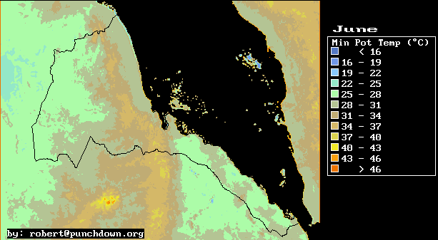
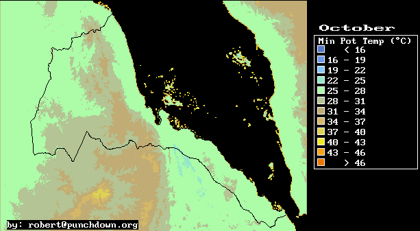
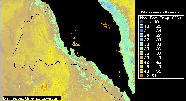
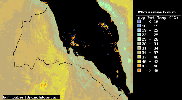
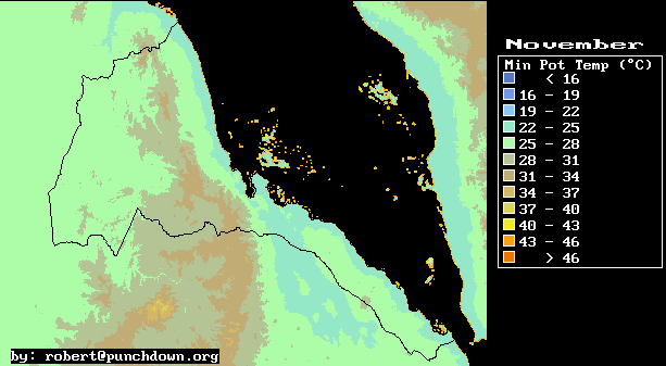
The result of this correlation analysis is a series of temperature maps. These maps provide monthly mean values for daily maximum, minimum, and average temperature for all of Eritrea. The estimated accuracy of the maps is 2�C for daily maximum temperatures, and about 1�C for daily minimum temperatures.
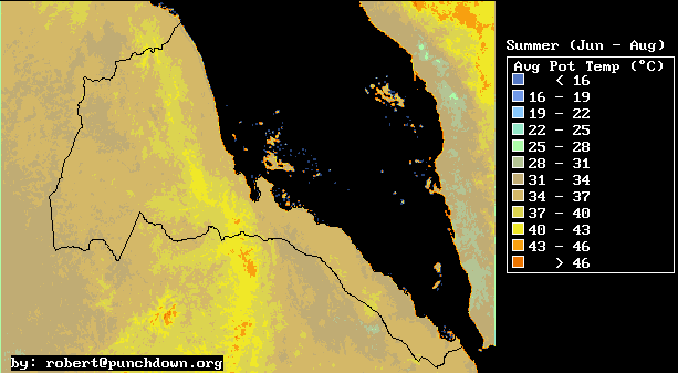
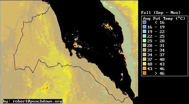
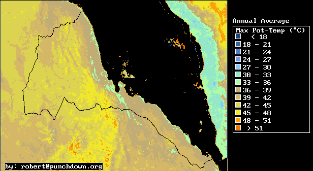
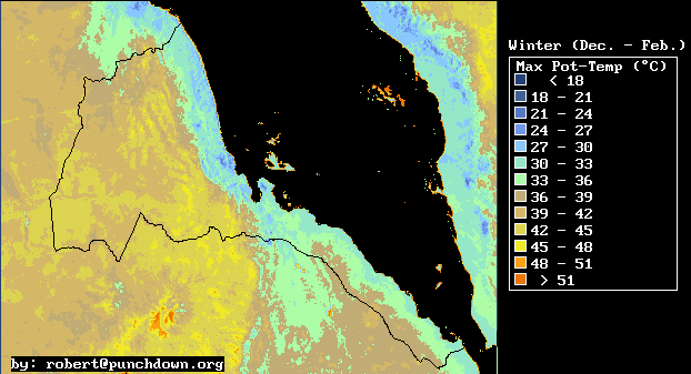
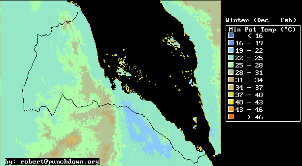
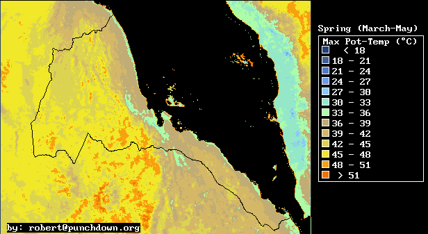
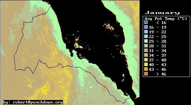
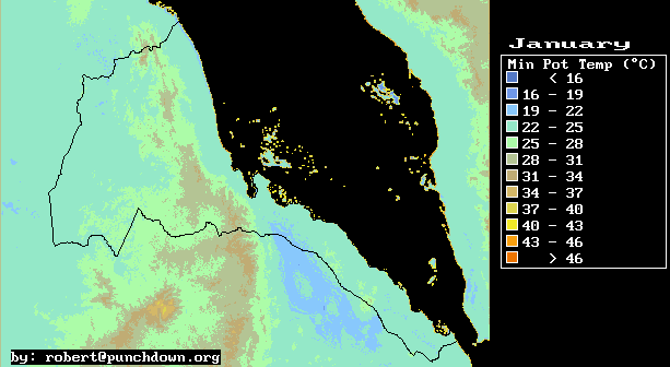
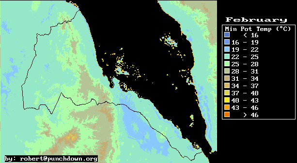
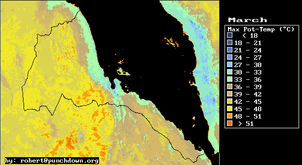
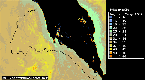
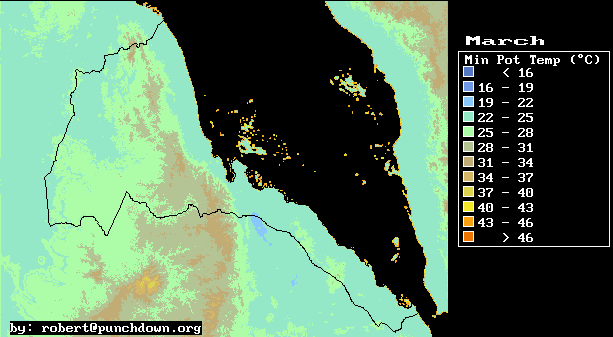
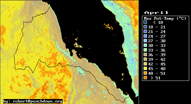
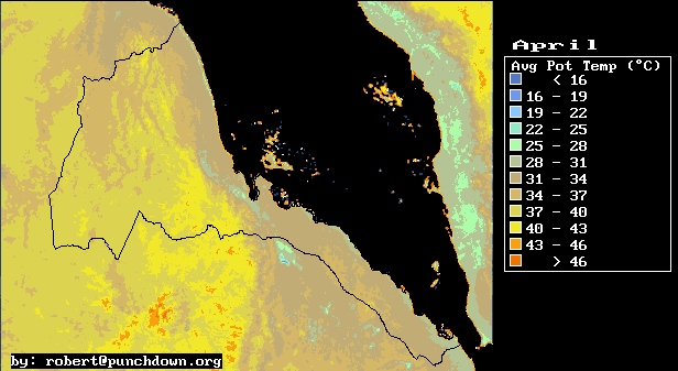
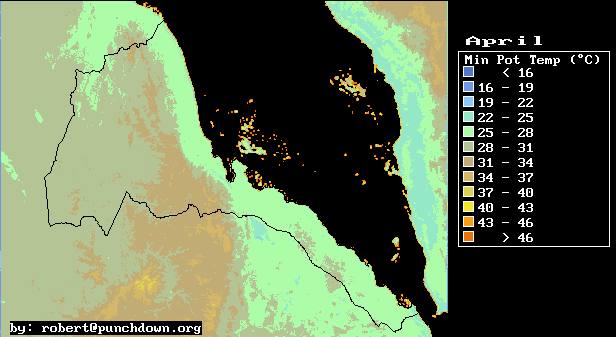
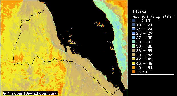
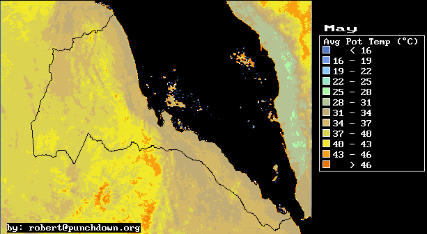
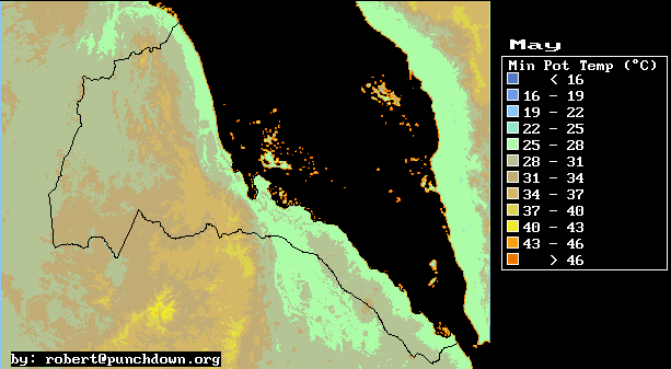
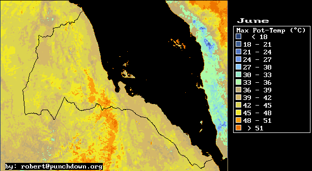
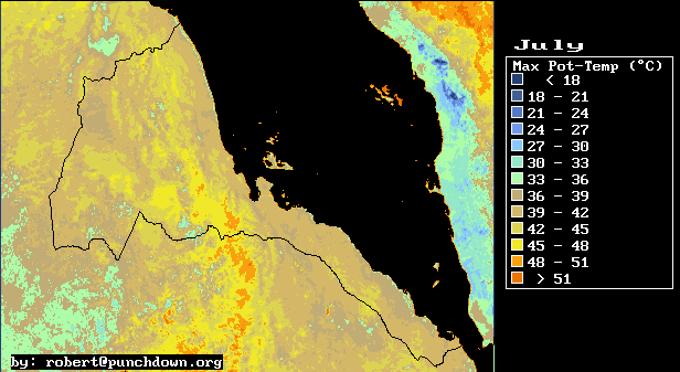
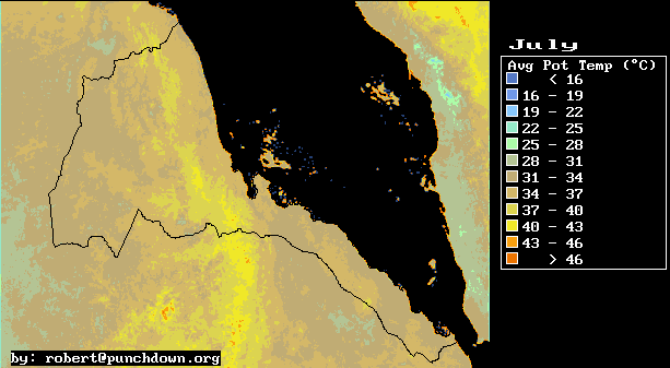
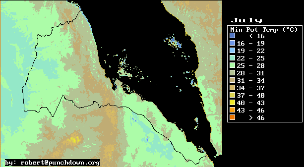
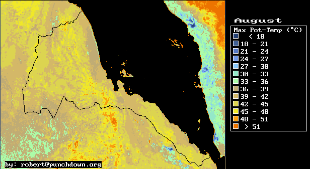
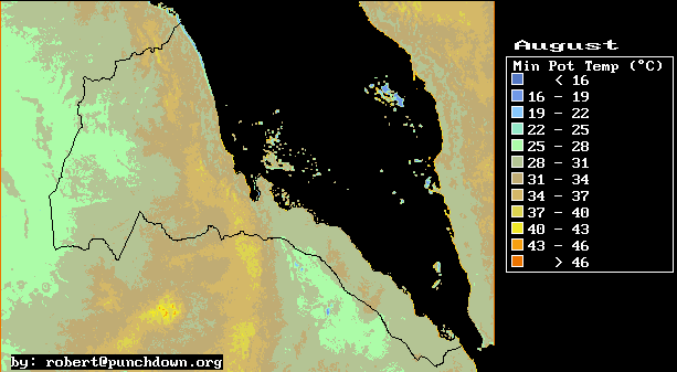
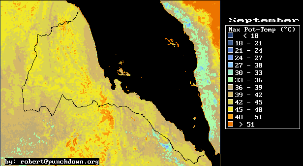
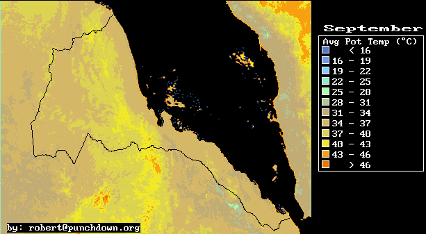
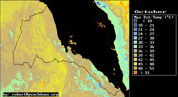
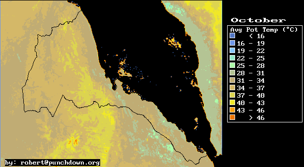
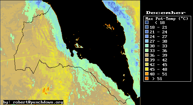
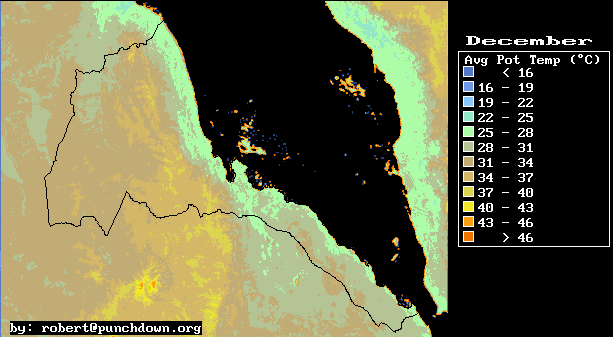
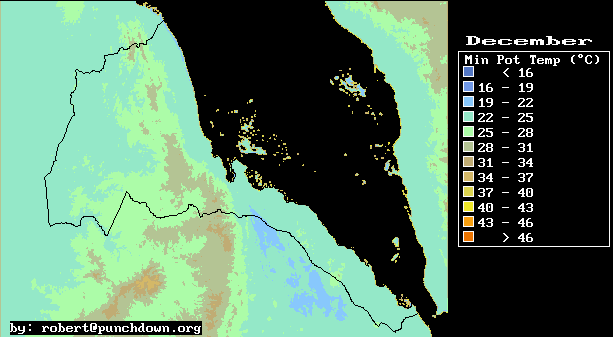
In addition to the temperature maps, we produced potential temperature maps. Potential temperature is the temperature that the air would have if it was moved, without heat exchange, to sea level. We provide potential temperature maps so that one can see the temperature of the different air masses, when altitude effects are factored out. These maps are instructive for meteorological analysis.
This maps were produced using the above described correlation relations and the image manipulation facilities of the Image Display and Analysis (IDA) program. IDA is a free-ware program. IDA runs on the DOS operating system, or in MSDOS mode under the different flavors of Windows.
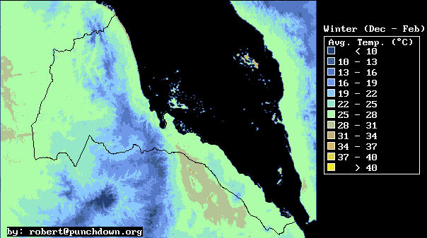
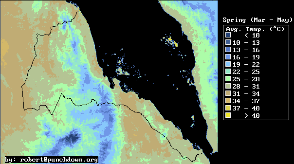
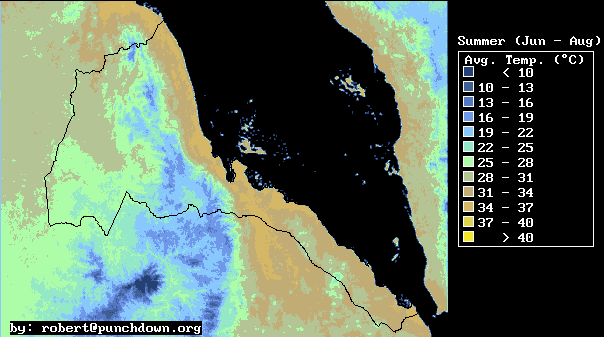
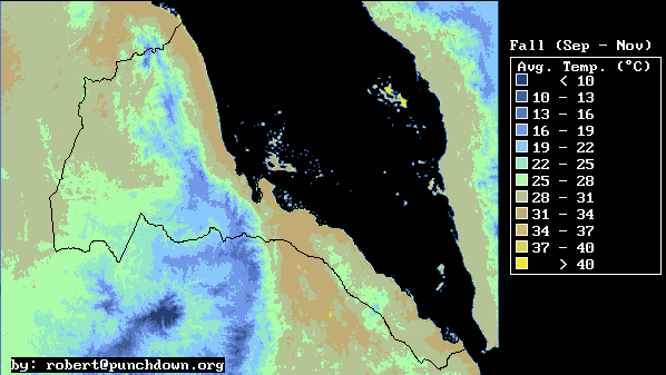
The resulting temperature maps show fairly mild seasonal changes in daily temperatures which are strongly influenced by altitude effects. The general pattern is that December through February are the coolest months, throughout Eritrea. Meanwhile the warmest months tend to be April and May for the Western lowlands and highlands, while they are June through August for the Eastern lowlands and Red Sea area.
| WINTER | SPRING | SUMMER | AUTUMN |
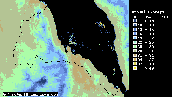
The above temperature map shows the different temperature regimes that exist in Eritrea.
The hottest area in Eritrea is--not suprisingly--the Danakil Depression. Here mean annual temperatures reach a peak of 32�C, and daily high temperatures average above 40�C (104�F) for four and a half months, from mid-May to September. During the summer months, nightime low temperatures are still a warm 30�C (86�F). During winter the daily temperature in this area moderates to a warm 28�C, swinging from a low of 23�C at night to a high of 33�C during the day in winter.
The coolest areas in Eritrea are the more elevated highland hills in the south, center, and north of the country. These areas have mean annual temperatures of about 18�C (65�F). The temperature swings from winter night-time lows slightly less than 5�C to daytime highs of 23�C (73�F) in late spring. In fact, the daytime high temperature in the Highlands above 2000 meters, is nearly always in the range of 20�C to 28�C. This combined with ample sunshine gives the Eritrean highlands a very pleasant temperate climate.
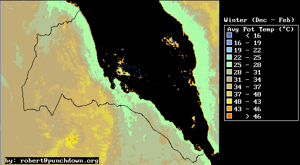
In this study we have produced a complete set of potential temperature maps in order to aid meterological analyses of Eritrea and its environs. The imporant feature of potential temperature is the fact that it indicates the relative temperature of two air masses when they are brought to the same location.
For example, the winter potential temperature maps show very clearly a cool layer of marine air near the Red Sea. Before factoring out altitude effects, it is not clear that the air at the Red Sea is effectively cooler than the air in the western lowlands. This is because the Red Sea area is also lower than the western lowlands. So altitude effects warm the Red Sea air due to adiabatic compression and make the actual temperature approximately constant at the two locations. But when we take a volume of Red Sea air, and move it over to the Western lowlands (without heat exchange) we find that it is infact cooler and denser than the corresponding Western air.
| ANNUAL | WINTER | SPRING | SUMMER | AUTUMN |
The cool Red Sea winter-time marine layer is 1000 to 1500 meters thick during the Winter season. At night, this layer is fairly quiescent, and distributed on both sides of the Eritrean Highlands. During the day, the air in the Western lowlands and Danakil depression heats up quickly, While the air over the Red Sea stays relatively cool. This causes winds in the Red sea to converge at Port Sudan where the cool marine layer moves inland. The cool marine air also flows into the Danakil depression where it is heated by the strong radiation from the cloudless skies at that location. This on-land heating of the marine air causes a strong on-shore wind at the Northern end of the Danakil depression at Tio, and at Port Sudan. The fact that marine air is drawn in at both the Danakil and Port Sudan means that high winds are experienced at Aseb where marine air is drawn in from the Gulf of Aden through the constriction at Bab al Mandab. This provides a rough explanation of the winter season wind patterns over the South Red Sea.
Finally we present a complete index of the maps produced in this study.
| Daily Maximum Temperature | Daily Average Temperature | Daily Minimum Temperature | |||||||||||||||||||||||||||||||||||||||||||||||||||
| Annual Average | Annual Average | Annual Average
| Winter Average
| Winter Average
| Winter Average
| Spring Average
| Spring Average
| Spring Average
| Summer Average
| Summer Average
| Summer Average
| Fall Average
| Fall Average
| Fall Average
| January
| January
| January
| February
| February
| February
| March
| March
| March
| April
| April
| April
| May
| May
| May
| June
| June
| June
| July
| July
| July
| August
| August
| August
| September
| September
| September
| October
| October
| October
| November
| November
| November
| December
| December
| December
| 12-Month Display
(400 Kilobytes)
| 12-Month Display
(400 Kilobytes)
| 12-Month Display
(400 Kilobytes)
| |
| Daily Max. Potential Temp. | Daily Avg. Potential Temp. | Daily Min. Potential Temp. | |||||||||||||||||||||||||||||||||||||||||||||||||||
| Annual Average | Annual Average | Annual Average
| Winter Average
| Winter Average
| Winter Average
| Spring Average
| Spring Average
| Spring Average
| Summer Average
| Summer Average
| Summer Average
| Fall Average
| Fall Average
| Fall Average
| January
| January
| January
| February
| February
| February
| March
| March
| March
| April
| April
| April
| May
| May
| May
| June
| June
| June
| July
| July
| July
| August
| August
| August
| September
| September
| September
| October
| October
| October
| November
| November
| November
| December
| December
| December
| 12-Month Display
(400 Kilobytes)
| 12-Month Display
(400 Kilobytes)
| 12-Month Display
(400 Kilobytes)
| |
This information has been prepared by Robert Van Buskirk. If you have any questions regarding some of this research please feel free to email me at robert@punchdown.org
Last update by rvb November 13, 1998.