| Technical Description | NDVI-based Estimates | Applications |
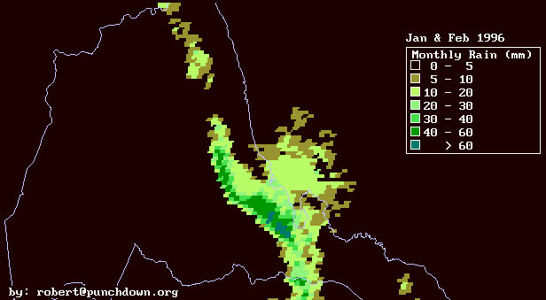
Average Monthly Rain
January to February 1996
| Technical Description | NDVI-based Estimates | Applications |
The above image is a map of estimated monthly rainfall from January to February 1996 which is based on visable Meteosat images. Many thanks to the Natural Resources Institute ( www.nri.org) for assisting with acquisition of images for this research. The image data was fit to rainfall data provided by the Civil Aviation Administration in Eritrea for 19 separate stations. Many thanks goes to the Civil Aviation Administration and Mengesteab Habtegiorgis for their cooperation in this research.
We did a one-parameter correlation of the rainfall with the square of the average net cloud reflectance in the visable part of the spectrum. The mean absolute deviation of the data from the image estimate is 4 mm, while the mean absolute value of the data is 17 mm. Hence the approximate error of the estimates is 25%.
Note it is reasonable that the data correlates with the square of the cloud reflectance, since we expect both the rainfall probability and rainfall intensity to scale linearly with mean reflectance. And the total rain will be proportional to rain intensity times the rain probability.
Also note that attempting estimates for shorter time periods will rapidly increase the error of the estimate. The fluctuation of an average scales as the square root of the number of events which are averaged. The number of events scales as the time period. So therefore the relative amplitude of the fluctuations scales as the inverse square root of the time period over which averages are being taken. Hence in this case for time periods of two weeks or smaller, our presumption would be that the deviation from estimate would be approximately the same size as the mean estimate.
The agreement between the data and the image pixels is shown in the following graph:
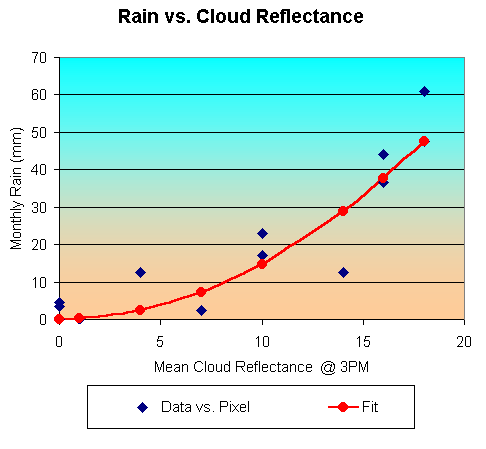
where the reflectance is measured in units of Meteosat pixel increments. We have not made the precise calibration between Meteosat pixel increments and reflectance, but it is probably about 30%-50% mean total reflectance for pixel values of 20.
Note that rainfall maps like these can potentially be combined with temperature maps to identify rough locations of locust habitat. Suppose that locust habitat depends on both temperature and moisture availablity. For example, perhaps locusts require more than 20 mm/month of rain, and mean temperatures above 20 degrees Celsius. Then the above rainfall map combined with temperature maps would identify the prime locust habitat for this period as the coastal plains from Massawa south to about 40 kilometers south of Arafaile.
This information has been prepared by Robert Van Buskirk. If you have any questions regarding some of this research please feel free to email me at robert@punchdown.org
Last update by rvb September 21, 1998.