Wind Resource Assessment of Eritrea, Africa:
Preliminary Results and Status
R. Van Buskirk(1), K. Garbesi(2) and K. Rosen(2)
(1)
Department of Energy, P.O. Box 5285, Asmera, Eritrea
(2)
Department of Environmental Studies, San Jose
State University, San Jose, CA 95192-0116, U.S.A.
ABSTRACT. We describe the approach for, and results of, a pre-feasibility assessment for wind resource development in the recently independent African nation of Eritrea. Sharp regional distinctions in landform and meteorology in addition to relatively scant historical wind data preclude a comprehensive assessment based on existing data, motivating a regional approach to the assessment using a diversity of techniques. Our approach combines remote sensing, simplified meteorological modeling, analysis of historical measurements, biological indicators, and short-term spot-measurements to characterize promising wind sites. The southern Red Sea coast is a rich wind resource. Long term Red Sea wind data from the Comprehensive Ocean-Atmosphere Data Set (COADS) reveal that average annual wind speeds at 10 m along the lower 200-km of coastline are from 6 to 7.5 m/s. The United States Air Force Environmental Technical Applications Center's (USAFTEC's) DATSAV hourly surface wind data for Aseb indicate annual mean wind speeds of 9 m/s for one site, with average winds above 11 meters per second during the winter monsoons from October through April.
Introduction
With the advent of global warming due to increasing CO2 emissions, it becomes imperative to develop economically viable strategies to meet the growing global energy demand with low-emission sources. Wind energy provides one of the more promising sources of renewable utility-scale electricity supplies. The lesser-developed countries (LDC's) are expected to provide the greatest increase in energy demand over the coming decades. To this end we describe efforts to characterize the wind energy resources in Africa's newest country, Eritrea. In this paper we provide a preliminary evaluation of wind energy resources along with a description of the methods employed.
In the most recent Ethiopian wind energy study (Mulugeta and Drake, 1996), rough large-scale maps are provided covering both Eritrea and Ethiopia. But this study and its predecessors lack the specificity necessary to guide either wind prospecting efforts or a more detailed monitoring program. The current study attempts to fill in that gap by providing a more detailed description of the wind meteorology, and by reporting preliminary results of wind prospecting efforts.
Data Sources
In addition to the satellite images, data were utilized from three additional sources. We used the COADS data for the Southern Red Sea to obtain the geographical distribution of wind speeds along the Eritrean coast. A second source of data was the United States Air Force Environmental Technical Applications Center's (USAFTEC's) DATSAV2 Surface Climatic Database obtained from the National Climatic Data Center, U.S.A. Both of these sources contain data for winds measured at a 10-meter height. Furthermore, 15-minute wind data is available for internal government use from seven recently installed first class meteorological stations in Eritrea: Asmera, Filfil, Kerkebet, Omhajer, Sh'eb, Shambiko, and Tsorena from the Water Resources Department of the Eritrean government. Wind measurements from these latter stations were taken at 3 meters.
Topography
Eritrea consists of two distinct lowland areas dissected by a central range of mountains. The Eastern lowlands are flat desert areas bordering the Red Sea where elevations range from 100 m below sea level to 500 m above sea level. There also exists along the Southeast coast a separate range of mountains that vary in elevation between 1000 and 2000 m. The Western lowlands consist of desert, hills, and savanna approximately 500 m to 1500 m in elevation.
The Central Highlands consists of mountains and plateaus that run Northwest-Southeast. The highlands range from 1500 m to 3000 m in elevation and are incised by canyons and valleys that may be as low as 1000 m. The Central Highlands are higher and wider below 15.5
° N latitude and between 16° and 17° N latitude. Above 17° N latitude, they descend into the plains surrounding Port Sudan. At the lower end of the study area (12° N latitude), there are no passes below 2300 meters in the Ethiopian Highlands, while in the central part of Eritrea there are a series of 1500 meter passes near 16° N latitude. Further north, the average height of the barrier rises again around the town of Nakfa at 17° N latitude before descending into the large broad flatland surrounding Tokar in the Sudan. Either side of the Central Highlands is flanked by steep slopes and canyons that are known as the Eastern and Western Escarpments.
Wind Meteorology
Overview
Like winds in California, the most consistently strong winds in Eritrea are produced by strong horizontal temperature gradients during the dry season (the time of the Northeast Monsoon in Eritrea). Regional pressure gradients during this season are produced primarily by the Central Asian High and the Equatorial African Low (Naval Oceanography Command, 1993). Dry air descending out of Asia cools due to evaporation when it reaches the Indian Ocean and the Gulf of Aden. This produces a cool humid inversion layer over these bodies of water. Synoptic pressure gradients then push the cool air to the West from the Gulf of Aden, but the westward motion is blocked by the Ethiopian highlands, which produce a topographic barrier that is consistently above 2000 meters high. This topographic barrier diverts the air in the inversion into the Red Sea and to the North into Central and Northern Eritrea and Northern Sudan. There, the cool sea air flows inland where it is heated and either rises into the Ethiopian Highlands or flows to the Southwest into the Equatorial Africa Low. Due to the low latitude and the relatively short distance scale of wind variations (10's to 100's of kilometers), Coriolis forces are weak and frictional forces often dominate near the land surface, producing conditions where wind velocity vectors are aligned with pressure gradients.
Winds in Eritrea are produced by a combination of synoptic-scale gradients, inversion layer dynamics, and local differential heating. Synoptic scale gradients, as indicated by monthly average pressure maps, are moderate (1 - 0.5 millibar/100 kilometers). Synoptic gradients combined with differential heating tend to produce wind velocities that are relatively low (mean velocities less than 4 m/s, and typically 1-3 m/s throughout the Eritrean interior). This is indicated by measurements at stations which do not have winds enhanced by inversion-layer dynamics and channeling.
.
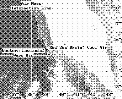
Figure 1 is a NOAA channel 4 satellite image from April 1996 during largely clear sky conditions at approximately 3 p.m. local time. The contrast in the image has been enhanced to sharply illustrate the boundary between the cool eastern air mass and the warmer Western air. This boundary occurs along the Eastern-most crest of the highlands. In visible images this crest also becomes the Western boundary of the Eastern Escarpment fog bank.
Characterization of the Inversion Layer
There are different types of inversion layers that can exist. We will make a distinction between a Surface Boundary Layer (SBL) inversion and a Planetary Boundary Layer inversion. The SBL inversion is typically a near-ground nighttime inversion which is a few tens of meters thick and which is heated and eliminated during the day. The PBL inversion, which will be the main topic of our discussion regarding wind meteorology, is the inversion at the top of the mixed PBL. This inversion layer is a few hundred to a couple thousand meters thick and below the inversion the air is well mixed during the day.
The PBL inversion layer can be identified and characterized through a combination of satellite images, cloud indicators, and temperature data. Infrared satellite images identify air masses with different temperatures and humidities. Also, a fog layer can assist in identifying the upper layers of the cold humid air mass and where the air experiences moderate uplift. Meanwhile, along the Eastern Escarpment in Eritrea temperature data show differences in potential temperature for nearby stations at different altitudes providing further indications of the persistent PBL inversion layer.
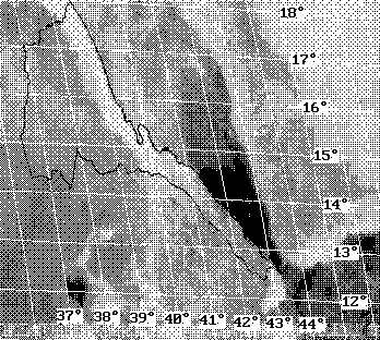
Figure 2 is the mean visible January 1996 Meteosat image for the region for 10:00 UMT (13:00 local time). In this image some low clouds are seen in the marine layer in the Gulf of Aden, but as the air passes through the mouth of the Red Sea at Bab al Mandab, the surface of the marine layer decreases in height as the air accelerates. This creates clear windy conditions which persist until 14.5
° N latitude. As the Red Sea widens at this point, the air decelerates and the marine layer thickens and rises causing the condensation of low clouds. A curved front marking the northern boundary of the jet can be seen in the low clouds between 15° and 17° N latitude.
Visible Meteosat images can be used to examine the motions in the inversion layer by illustrating low-cloud patterns in the Southern Red Sea.
Temperature data provides an indication of the strength of the inversion. January temperature data for highland stations indicate a mean daily maximum potential temperature (assuming a dry adiabatic lapse rate of 9.8
° C/1000 m) of 45° to 49° . Meanwhile, along the Eastern Escarpment at elevations below 1500 m the daily maximum potential temperature suddenly drops to below 38° . This indicates a very strong 10-degree inversion over an elevation range of less than 1000 m. During the night, the top of the inversion may rise to above 2000 m, and weakens to 4° -8° . It is the dynamics of this 4° -10° inversion which creates the most promising wind sites in Eritrea.
Highland Wind Sites
Once it is recognized that synoptic pressure gradients are weak and a strong inversion layer exists that flows through complex topography, it becomes necessary to analyze inversion layer dynamics as a possible source of high-wind conditions. Such an inversion flowing through a topographic barrier into a warmer basin of air will have the largest flows through the lowest passes. Furthermore, steep slopes on the lee side of the passes will provide additional acceleration of the flow. Hence the areas most intensely investigated for potential wind energy sites have been highland passes with leeward slopes along the cold-warm air interaction line.
Using the above criteria, the Department of Energy has been undertaking occasional spot-measurements of sites along the interaction line where warm western air interacts with cooler eastern air (see figure 1). It has been observed that several sites in this zone have daytime wind speeds in excess of 10 m/s during the high-wind season (compared to 5-7 m/s for Asmera), but sites which are clearly feasible for utility-scale generation have not yet been found.
Investigations have focused on two areas located approximately 40 km North and South of the Eritrean capital of Asmera: Adi Teklezan and Dekemhare respectively. These sites indicate mean daytime peak winds of 9 - 11 m/s (approximately 1.5 to 2 times the velocity in Asmera) during the high-wind season at 5 m elevation.
Dekemhare appears to have winds which correlate to some extent with those in Asmera. Correlations with spot measurements give a relation of VDekemhare = 0.9 VAsmera + 3 m/s during Easterly winds and VDekemhare = 1.1 VAsmera + 1 m/s during Westerly winds for measurements taken during the day and evening (until 20:00). The r-squared values of these correlations are 0.6 and 0.8 respectively. Measurements taken with a recently installed automated data-logging station in Asmera indicate mean wind speeds in Asmera of approximately 3 m/s at 12 m height. The Dekemhare wind sites might be feasible if either sites with improved topographic enhancement are found, or higher measurements (at 30 m or 40 m height) indicate substantially higher wind speeds.
Adi Teklezan is located near deeper passes through the highlands which channel larger flows from the Red Sea basin to the Western lowlands. During Westerly or Southerly winds in Asmera, winds in Adi Teklezan are of similar magnitude. But when winds are Easterly, daytime winds in Adi-Teklezan are approximately 50% higher than those in Asmera. In addition to this, when moderate night-time Easterly winds exist in Asmera, strong night-time winds may exist at Adi Teklezan. Recent spot measurements have shown one-hour mean night-time wind in Adi Teklezan can be as high as 10 m/s at 5 m height when the night wind speed in Asmera at 12 m height is below 4 m/s. One week of continuous monitoring has indicated a mean wind speed of 5.4 m/s at 5 m during a period when winds in Asmera were 2.7 m/s at 12 m. If measurements at larger heights can yield a 20% increase in wind speeds, then this site may be marginally feasible. The lack of correlation with Asmera, and the existence of strong night-time winds warrants further investigation of the winds in this area.
Southern Red Sea Jet
The best wind sites in Eritrea are located between 12.5
° and 14.5° North latitude along the Southeast Eritrean coastline. The high winds in this area are produced by channeling and topographic enhancement of the Southeasterly flow in the South Red Sea inversion during the dry season.
As described above, the inversion at the Eritrean Eastern Escarpment ranges from 1500 to 2500 meters. Meanwhile, during the winter, airflow in the Red Sea is from the Southeast. This means that mountains along the Eritrean and Yemeni coast, which rise to above 2000 meters, can channel the inversion layer as it flows from the Gulf of Aden into the Southern Red Sea. This channeling -- because of mass conservation -- forces the flow to accelerate through constrictions in the Southern Red Sea.
Using the COADS data set for the Southern Red Sea, one can characterize the geographic variations of the wind speeds near the Eritrean coastline in the Red Sea and the approximate jet dynamics. Figure 3 shows the coastal wind speeds and barometric pressure for the Eritrean coast based on COADS data. Both wind and pressure are shown for the high wind season (Oct-Apr) and for 3:00 and 15:00 local time. It is seen that wind speeds are highest from 12.5
° to 14.5° N latitude. The reason for this can be seen in the coastal pressure pattern. Before entering the Red Sea, the pressure is high due to the large depth of the marine inversion layer. But the marine inversion layer depth is hundreds of meters lower in the Red Sea, and creates a large decrease in pressure through the Bab al Mandab straight. This steep pressure drop accelerates the flow slightly North of Bab al Mandab, and further acceleration occurs along the lee slopes of the hills around Aseb. Furthermore, as the flow is forced through the topographic constriction produced by 2100 m Mount Ramlu, the flow reaches its maximum velocities. The continued confinement of the flow by mountains in both Eritrea and Yemen in the Southern Red Sea area up to a latitude of 14.5° N keeps wind velocities high up to that point. Above 14.5° the Red Sea widens considerably and night-time wind speeds decelerate from above 7 m/s to below 5 m/s within 50 kilometers in this area.
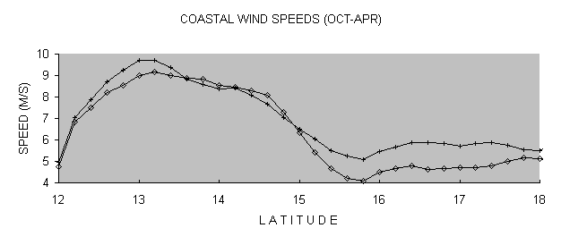
Figure 3
. Eritrean coastal wind speeds and barometric pressure for 3:00 (¨ ) and 15:00 (+) local time, during the high-wind season (Oct-Apr). Horizonal axis is North latitude of coastal point.
For a detailed assessment of wind patterns we analyzed over 3000 instantaneous wind velocity readings for each of two stations near Aseb, slightly south of the point of maximum constriction. These stations show similar wind patterns but have winds of significantly different magnitudes. Both sites are near Aseb or slightly to the west. One site (station #1) has an estimated mean wind speed of 9.2 m/s at 10 meters, while the other has a mean speed of 6.9 m/s at the same height. Both sites show distinct high and low-wind seasons where wind speeds are approximately 4 m/s lower during the low-wind season. Meanwhile figure 4 shows the average daily wind cycle for station #1 for both the high-wind and low-wind seasons. It is seen that during the high-wind season, the wind peaks in early afternoon at values above 12 m/s and appears to be lowest in very early morning.
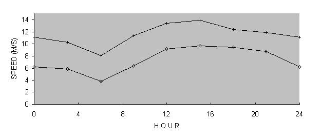
Figure 4:
The mean daily wind cycle for station #1 near Aseb. Results are shown for the (¨
) low-wind (May - Sep.) and (+) high-wind (Oct.- Apr.) seasons.
Wind Power & Capacity Factor Estimates
We provide a preliminary evaluation of wind energy potential at both sites (a more detailed evaluation will have to await the results of current monitoring efforts). To evaluate the wind energy potential, the relevant statistics are described by the power density function [Troen & Peterson, pg 97]. Meanwhile, for purposes of economic evaluation of potential projects, we also estimated the approximate capacity factor of turbines that might be installed in such a site. For the capacity factor estimate, we used the power curve for a Flowind AWT-27 rated at 250 kW to provide estimated capacity factors. In these calculations, we obtained the following values for the Weibull distribution parameters k and A, total power density (Pd), and capacity factor (Cf):
Table 1: Weibull parameter values, power densities, and capacity factors for Aseb Sites
k A Pd (W/m2) Cf
Station #1 High-wind 3.0 12.9 1210 0.71
Low-wind 1.9 8.5 460 0.35
Annual 2.2 11.5 895 0.56
Station #2 High-wind 2.5 10.1 670 0.48
Low-wind 1.3 5.1 170 0.14
Annual 1.6 8.6 467 0.36
In performing these calculations, data was binned into 3-hour intervals. Then the statistical distributions were analyzed for each interval and the average distribution was used for the aggregate calculation. This eliminates bias due to uneven sampling. For stations #2, there was sufficient data for all hours, while for station #1 there was insufficient data for the hours 3:00, 21:00 and 24:00. To interpolate for these hours the linear correlation between the k and A values of station #1 and station #2 were calculated for the available data and this relation was used to estimate the values of k and A for the missing hours.
In reality the capacity factor may also depend on the maintenance schedule and the turbine downtime at a wind power site, but we calculate the raw capacity factor integrating the turbine power curve with the velocity density function. Note that very high capacity factors are estimated for site #1 indicating an annual average capacity factor exceeding 50%. Compared to international average capacity factors of approximately 25%, this indicates that wind energy production at an enhanced South Red Sea site may cost half as much per kilowatt-hour as the international average (all other factors being equal).
Considering that these calculations were performed with 10 m wind data with no extrapolation to hub height, wind speeds and capacity factors at a hub heights of 30 m to 40 m may be even greater. Furthermore, the low daily and statistical variation (indicated by k > 2 for large A) means that turbines should operate a large fraction of the time at designed wind speeds. It is apparent from such data that Eritrea likely has wind energy sites near Aseb of the highest quality.
Summary/Conclusions
In Eritrea, the most promising wind energy sites exist by virtue of channeling and local enhancement of flows in a wintertime inversion layer. This inversion layer originates in the Gulf of Aden, flows to the Northwest into the South Red Sea and proceeds across the Northern tier of the Ethiopian highlands into the Eritrean and Sudanese lowlands. The inversion layer flows are channeled and accelerated in two areas: first at the mouth of the Red Sea where the point of maximum constriction is at Mt. Ramlu in Eritrea, and then through passes in the Eritrean Highlands.
The South Red Sea channeling produces excellent wind sites with wind power densities exceeding 850 W/m2 at 10 m. Wind turbines situated at such sites could possibly be operated with capacity factors exceeding 50%. Highland sites are more marginal because of the nighttime decrease of wind velocities. This means that while daily peak winds may often exceed 10 m/s, rough estimates of the average wind speed yield 5-7 m/s at 5 m. indicating that these are marginal but possibly economical sites.
Wind power development along the Southeast Eritrean coast would likely be very economical, either yielding low electricity costs for government-lead development, or potential high returns for private investors. For power transmitted to the central national grid, transmission costs would require economies of scale that would dictate a minimum project capacity exceeding 50 MW. Since this is comparable to current national demand, such a national scale project would have to wait perhaps 5 to 15 years for demand (currently growing at 10% per year) to grow to the level where it could absorb such a large increase in supply.
Nonetheless, whether we contemplate a near-term three megawatt development or a long-term 50 megawatt development, it is to the benefit of both Eritrea and interested international partners to aggressively pursue wind energy development at this juncture.
ACKNOWLEDGEMENTS
This work was undertaken at the initiative of the Government of Eritrea with collaborative assistance from San Jose State University, U.S.A., sectoral support from the State of Lower Saxony, Germany, and private support from Dullas Engineering, U.K.
REFERENCES
[1] Garbesi, Karina, Kello, Karen & Van Buskirk, Robert (1996). Preliminary wind energy resources assessment for Eritrea, Department of Energy, P.O. Box 5285, Asmera, Eritrea, 54 pp.
[2] Mulugeta, Yacob & Drake, Frances (1996). Assessment of solar and wind energy resources in Ethiopia. II: Wind energy, Solar Energy, Vol. 57, No. 4, pp. 323-334, 1996
[3] Naval Oceanography Command Detachment (1993). U.S. Navy regional climatic study of the Red Sea and adjacent waters, National Oceanic and Atmospheric Administration, Asheville, North Carolina.
[4] Peterson, Erik L., Mortensen, Niels G., & Landberg, Lars (1994). Wind resource assessment and siting--a wider perspective, In: European Directory of Renewable Energy Suppliers and Services 1994. James and James, London.
[5] Rosen, Karen, & Garbesi, Karina, (1997) Eritrean wind energy potential, (in preparation).
[6] Troen, Ib, and Peterson, Erik L., (1989) European Wind Atlas. Riso National Laboratory, Roskilde, Denmark.