The feasibility and applicability of wind energy development depends on the particular social, economic, and physical characteristics of both the study area and the wind resource. In this section we describe the Eritrean geography and demographics, the conditions of the energy sector, including a description of the two main national grids at Asmera and Aseb, and the large wind flow patterns in the area.
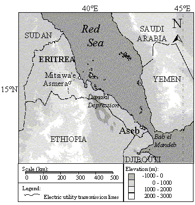
Eritrea is a small, developing country in northeastern Africa with an estimated population of 3.6 million (CIA 1997). Eritrea occupies the southernmost 1200 kilometers of the Red Sea's western shoreline, including hundreds of islands near the major ports of Mitsiwa'e in central Eritrea and Aseb in the south (see Figure 3).
The capital, Asmera, is located in central Eritrea on a plateau at over 2000 meters elevation. This high plateau and the surrounding hillsides are known as the central highlands. Roughly 20% of the Eritrean population lives in Asmera, and, although accurate population counts for other major cities are not available, it is estimated that more than half of the Eritrean populace lives in the towns and cities of the highlands. This area is cooler and wetter than the lower elevations in Eritrea, with up to 61 centimeters of rainfall annually (Landsberg 1972).
Figure 3. Map of Eritrea showing topography, the capital--Asmara, surrounding countries, and major bodies of water.
To the west and east are the western and coastal lowlands, respectively. The western lowlands have a semiarid climate and consist chiefly of desert hills and savanna. To the east, the high plateau drops abruptly to a wide, arid coastal plain that stretches the entire length of Eritrea. South of Mitsiwa'e, this coastal plain dips to 100 meters below sea level at the Danakil depression, which divides the central highlands in the west from a much smaller range of mountains in the east. This second range parallels the shoreline from the Danakil depression to beyond the Djibouti border, reaching almost 2000 meters at its highest point. The extremely hot and arid Danakil depression to the west, the mountains to the south, and the Red Sea to the north and east contribute to the isolation that inhibits settlement in this part of Eritrea. Current maps of Eritrea show settlements in this area to be relatively few and far between.
The Eritrean coastal plain is a hot, dry desert. Summer temperatures from June to September average 35-45ºC and rain is rare. Annual rainfall ranges from about 3 centimeters in the driest years to about 26 centimeters in the wettest (Landsberg 1972). Because of the extreme heat and aridity, few people live along the coast.
The largest city in this part of the country is Aseb, a port city of
about 50,000 people located at the southernmost tip of the Eritrean coastline.
The annual rainfall in Aseb is about two inches, and the landscape consists
of wind-blown sand near the ocean, basaltic lava flows, cinder cones and
salt flats. The Aseb economy relies on the port, the national petroleum
refinery, and a small fishing industry. Drinking water at Aseb is available
through groundwater resources and the local inhabitants supplement their
diet and income with fishing and trading. The Aseb Airport, about 10 kilometers
northwest of Aseb, provides the best transportation to and from the town
since roads in the region, where they exist, are badly damaged.
The Eritrean energy sector is characterized by a relatively low level of electricity supply, an over-reliance on biomass, and a large latent energy demand. About 80% of the population is without residential electricity, with demand exceeding supply by as much as 150%. An estimated 82% of energy needs are met with biomass resources, while 16.8% are met with liquid petroleum fuels. Only 1.2% of energy is consumed in the form of electricity (Habtesion 1994).
From 1992 to 1995, actual electricity production in Eritrea increased at an annual rate of 10%. By 1997, Eritrea had a firm electric capacity of about 60 megawatts and generated about 150 gigawatt-hours (GWh) per year. The cost of electricity production in Eritrea is approximately 0.45 Birr/kWh, or 6.5 cents in U.S. currency. Current Eritrean government energy policy goals include expanding the electricity supply by at least 6% per year.
The Main National Grid at Asmera
The main national electric grid in the central highlands has a formal capacity of 40 megawatts. In practice, however, the actual generation capacity is approximately one half the formal generation capacity because many generators are old and inefficient. Transmission lines stretch from Mitsiwa'e to Asmera, and then continue south, for a combined length of about 500 kilometers (see Figure 3).
From 1992 to 1995, expansions in the Eritrean electric utility sector occurred primarily through improvements and expansion of the main grid in the Eritrean highlands. The Eritrean government has approved further expansion with the construction of an 84 megawatt heavy fuel-oil fired power plant near Mitsiwa'e that is expected to be completed in 1998.
The Secondary Grid at Aseb
A second grid, with a capacity of 17 megawatts, is located at Aseb. There are three power generating institutions in Aseb: the Eritrean Electric Authority (EEA), the Aseb port, and the petroleum refinery. The EEA and the refinery are the largest producers, with the refinery generating slightly more than the EEA. During minimum loads, the refinery produces all power for both itself and the town. Meanwhile the port is a smaller user that prefers to operate independently, and that incurs the largest unit generation costs. Demand at the port fluctuates depending on the number of ships docked, as they require 300 kilowatt cranes for unloading.
Electricity demand at Aseb is currently met by several aging diesel generators, many of which are not very efficient and, therefore, expensive. The combined capacity of the power system is approximately 17 megawatts, though this may soon decrease to 11 megawatts as the generators at the refinery undergo rehabilitation. The average combined demand of the town, the refinery and the port is 5.3 megawatts, fluctuating from a low of 4.0 megawatts during the cooler winter monsoon season to a high of 8.1 megawatts in the hot summer monsoon season. The Aseb power generation system and associated costs are summarized in Figure 4 (Van Buskirk 1997).
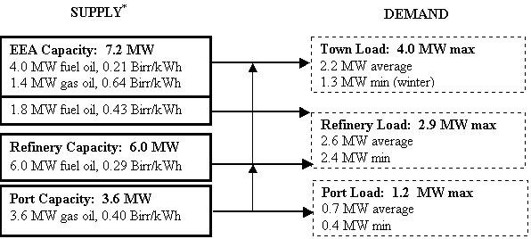
*Gas oil 1.53 Birr/l; EEA fuel oil 0.78 Birr/l; refinery fuel oil 0.735 Birr/kg, where 6.45 Birr = 1 US$.
Figure 4. Diagram showing power supply, power demand and energy costs at Aseb
Pressure systems due to differential heating and cooling of Asia, Africa and the Indian Ocean are the main forces behind air movement in the Red Sea region. These systems give rise to two distinct monsoons. From November to March, the southern half of the Red Sea is dominated by what is called the Northeast Monsoon. Early in winter, the cold Siberian high pressure zone is formed near 50°N 95°E, while the African equatorial low is formed near 10°N 30°E. The clockwise air movement around the Siberian high and counterclockwise air movement around the Sudanese low converge at the Gulf of Aden. This creates a strong southeast wind that forces air through the narrow Bab el Mandeb at the southern mouth of the Red Sea. At the same time, clockwise air movement around the Saharan high over northern Libya and west-central Egypt forces air in the northern half of the Red Sea to blow from the northwest (Brower, Baldwin and Franks 1993). The two winds converge at about 15°N, creating the relative calm winds off the coast of Mitsiwa'e, where much of the combined air mass is drawn southwestward across the Eritrean highlands toward the African equatorial low pressure system centered in southern Sudan. These air motions produce two high wind locations: the southern Red Sea, and the lower passes of the Eritrean highlands, where cooler denser air is accelerated as it is forced through topographic constrictions (Van Buskirk, Garbesi and Rosen 1997).
From May to September, winds in the Red Sea are affected by what is called the Southwest Monsoon. Increased insolation and low heat capacity of the Asian land mass during the early summer months promotes the formation of the warm Pakistani low centered near 30°N 65°E. In Africa, the Azores high produces a strong northwest wind over the northern half of the Red Sea (Brower, Baldwin and Franks 1993). The result is that surface winds along the entire length of the Red Sea blow from the northwest, down the length of the Red Sea, and out into the Gulf of Aden.
While seasonal wind patterns in Eritrea are caused by the Northeast
and Southwest Monsoons as described above, diurnal wind patterns are caused
in large part by local land-sea breeze effects. When the land mass south
and west of Eritrea warms during the daytime, the air mass above it is
also warmed. This warm air rises, while cooler, denser air from over the
Red Sea flows in to replace it. The result is a cyclic diurnal wind speed
pattern, with wind speeds peaking during and after the hottest parts of
the day and then dying down during the nighttime.