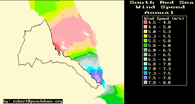
Figure 1: A map of Red Sea wind speeds derived from the COADS ship-based meteorological data.
Accurate and accessible climate and resources information is a very
important asset for all facets of socioeconomic development.
Like in most developing countries, the majority of Eritreas population
is directly dependent on climate and natural resources for their economic
livelihood. Optimized national development will require maximum net long-term
returns on limited resources and capital available for investment. Net
returns are maximized by minimizing the cost of capital and investment
risk while maximizing the benefits and revenues that accrue from investments.
Improvements in the information available for project, policy and investment
evaluation can result in very significant net improvements in national
investment and policy efficiency. In this paper we outline potential methods,
technologies, and development paths for enhancement of climate and resources
information system infrastructure using computer and Internet technologies.
We also discuss how such development could lead to an exportable, highly
valuable national policy and planning services capability.
In Eritrea a number of institutions are involved in climatic data collection for their local usage. However, there is still a lot to do in terms of climatic data collection, archiving and processing in a consistent format for easy access and retrieval. To be of value, the climatic data from numerous sources must be collected, validated, documented, processed, analyzed and modeled and be made readily available to the scientists and decision-makers who will use the data. Only through this process will the optimum economic benefit be obtained from many and varied weather and climate observing and resources monitoring networks throughout the country.
In this paper we discuss the importance and applications of climate and resources and information systems for Eritrean development. We describe some of the accomplishments we have made so far in climate and resources information system development using computer and Internet technologies. And finally we discuss future needs and plans on the area of climate and resources information.
In this section we describe the different sectoral applications of climate and resources information and the attendant benefits.
Food is very critical issue in countries like Eritrea, where traditional rain fed agriculture is very dominant and marked large intra-seasonal and inter-annual climate variation in both the amount and distribution of rainfall. In light of this there is high demand by agriculturalists, planners and higher decision-makers for accurate, reliable and real time climatological and meteorological weather forecasts and advice. Because of the dynamic nature of climate and weather, forecasts involve a lot of resources such as skilled labor, a good network of meteorological stations, and communication and computer facilities. Such resources are quite scarce in Eritrea at this time.
In agriculture and horticulture the needs of climate and resource information are at top priority. The duration of the growing season is a function of plant type and air temperature. Both livestock and crops depend on the availability of water, which is usually derived from local or watershed precipitation. Even the time of day that precipitation occurs is important to the efficiency of water utilization. The heat tolerance of plants and animals determines what climates are favorable for different species. In general from selection and preparation of farmlands up to storage of harvested field crops, all agricultural activities call for adequate information of climate and resource information. With proper policies and construction of irrigation facilities, not only will Eritrea be self-sufficient but it has also the potential to revive its old record of exporting fruits and vegetables to Middle East and Europe.
Application to Locusts: High-resolution satellite NDVI (Normalized Difference of Vegetation Index) images combined with rainfall and temperature maps can potentially used to identify locations of locust habitat. Locust habitat depends on both temperature and moisture availability. Real-time estimates of the moisture and temperature can aid in identification and monitoring of locust habitat, and locust control.
The major Agricultural climatic products can be listed as follows: rainfall data/maps, temperature data/maps, vegetation index (NDVI), soil water satisfaction index, solar radiation, wind data and humidity. In addition to this, periodic agrometeorological bulletins are very useful for monitoring purposes. These bulletins provides those sectors of the community involved in agriculture and related disciplines with the current weather situation in relation to known agricultural practices. The information contained in the bulletin are believed to assist planners, decision-makers and the farmers at large, through an appropriate media, in minimizing risks, increasing efficiency, maximizing yield. On the other hand, it is a vital tool in monitoring crop/weather conditions during the growing season, to be able to make realistic assessment of the annual crop production before harvest.
River runoff or discharge is considered to be an excellent integrator of climatic factors, which makes it an important indicator of climatic variability and change. Long climatic records of runoff are essential to determining whether runoff is changing over time. Similarly, discharge also integrates numerous human influences such as flow diversions for irrigation and municipal use, natural stream flow regulation by dams and reservoirs, and base flow reduction by groundwater pumping. The hydrologic system is an integrated component of the earth's geophysical system and both affects and is affected by climatic conditions. Changes in temperature affect evapotranspiration rates, cloud characteristics and extent, soil moisture. Changes in precipitation affect the timing and magnitude of floods and droughts, shift runoff regimes, and alter groundwater recharge characteristics. Synergistic effects will alter cloud formation, vegetation patterns and growth rates, and soil conditions. At a larger scale, climate changes can affect major regional atmospheric circulation patterns and storm frequencies and intensities. Climate changes can also affect disease vectors like mosquitoes. All of these factors are, in turn, very important for decisions about water and land-use planning and management. Experience with historical climatological and hydrological conditions plays a major role in determining current water-use patterns and the infrastructure and institutions to regulate and allocate supplies.
Many traditional information collection and distribution systems in Eritrea involve the development of specialized government technical departments that develop their systems individually. Typically there may be a data collection and monitoring branch, that collects climate, agricultural or environmental data and observations from a variety of sources. Then there is a data dissemination office that receives requests for information and data. And there also may be a research and analysis division that performs specific reports and analyses.
With the tremendous progress and advance of information technologies in the last two decades it now may be possible to automate many of the repetitive aspects of the data collection, analysis, and dissemination process so as to dramatically increase the productivity and efficiency of technical climate and resources information.
Much climate and environmental data can now be collected automatically over computer networks (for example in the collection of satellite images, or modem transfer of data from automated data collection stations). In addition, the data that is still collected manually can be entered into a database over computer communications networks. Then this information can be stored on servers that perform data processing, physical modeling, and information dissemination services. These same (or different) servers can then provide the Internet or Intranet site that can provide user access to the resulting information products.
In summary, the information system technology can be broken down into three components:
In addition, the data collection server can provide an Internet interface for data entry into information system databases, or the server can be programmed to call via modem other computers or data collection equipment for automated data collection over phone lines.
Data storage effectively is in a database, which can either be maintained with database software, or it can be maintained in a more ad-hoc fashion using a specific filing and data storage scheme.
Data Collection and Storage
|
V
Information Processing and Modeling
|
V
User Presentation and Access
The information-processing component obtains the raw data it processes from the data collection and storage system. The output from the information-processing component then gets processed and formatted for presentation by the user processing and access component.
An example of how this works is that the data collection and storage for surface temperature maps first pulls the relevant satellite images from the Internet, and then scales and projects the satellite data to a standard projection for the Eritrea area. Then the information-processing and modeling layer takes the station observations of temperature and develops correlation relationships between the observed surface temperatures, elevation, and satellite image data. These correlation relationships are then used to estimate temperatures to produce fairly high spatial resolution maps of temperature. The high-resolution temperature maps may then be presented to users over an Internet web site, as color images, or as text or HTML data tables of temperature estimates for specific locations.
We plan to develop high-resolution meteorological models that can perform detailed high-resolution estimates of the full meteorological dynamics over Eritrea. Such models would take real-time satellite data and ground measurements, and then find the set of dynamical conditions that best match the observed meteorological data. The information from the best-fit simulation or model would then provides an extrapolation of the meteorological parameters from the observed locations to the rest of the region around Eritrea. The model estimates are then provided to users through the user access interface.
We therefore wish to explore a user access model that attempts to maximize the speed and efficiency of information delivery for all users. In this model the user interface takes the information outputs that are provided by the information-processing and modeling component and converts and translates them into different forms and formats that may be useful to users.
One of the user-formats be a dynamic Internet search or Internet page type of interface. This interface is a web site with search and information display capabilities. It would allow users to access different information categories and view different maps, data tables and technical documents. In a very preliminary way we have provided such an interface to some climate and resources products at: http://www.punchdown.org/rvb/. The site may also have several different types of information retrieval interfaces that allow users to specify the time period, location, and other characteristics of the desired data. The retrieved data can then be delivered in tabular, map, image, or graphical form, and in different languages. In addition, different levels of user access can be specified to enforce a desired permission or payment scheme for information services.
Note that as we describe our efforts for the development of a the climate and resource information system, that there are various agencies and ministries in Eritrea are developing similar information system components. In this effort we describe the development of an Internet-based climate and resources information system that integrates many different components. While this effort may duplicate some of the work done by others, we consider it a verification or validation of that work which can be done in collaboration and coordination with the existing efforts as resources permit.
Given the information system technologies at our disposal, and the applications for the climate and resources information in Eritrea we envision a climate and resource information system with the following components/elements:
The ecology and agricultural component will monitor the health, growth, and production of Eritrea's ecosystem and agriculture. This shall include monitoring vegetation, land use changes, agricultural production, rangelands, and forests/brushlands.
The energy resources, supply, and demand component shall estimate, monitor and forecast solar energy resources, wind energy resources, biomass resources, and domestic energy demand.
The water resources and hydrology component will monitor and estimate rainfall distributions and the impacts on surface water run-off, soil moisture and groundwater infiltration and recharge.
The topography and physical geography component will build an information base for the physical topography, geomorphology, soils, and sedimentation and erosion.
The marine resources and environment component will monitor and estimate Red Sea winds, currents, sea surface temperatures and potentially plankton production (sea water color).
The maps were derived from Advanced Very High Resolution Radiometer (AVHRR) data obtained from public archives at the U.S. Geologic survey. We used AVHRR Channel 5 thermal infrared images and station elevation data to develop a two variable correlation with mean daily temperatures. The temperature data was obtained from the classic work on Eritrea meteorology and climate: Contributo all Climatologia Dell'Altopiano Etiopico, Regione Eritrea by Amilcare Fantoli, 1966.
To produce the temperature maps, we downloaded decadal Channel 5 AVHRR images from http://edcwww.cr.usgs.gov/landdaac/1KM/comp10d.html.
The decadal Channel 5 images often contained some cloud contamination that obscured the infrared emissions from the ground. So it was often necessary to composite several images from the same month. We did this by taking the maximum of several images to compose the composite monthly Channel 5 image.
We then correlated this image data in combination with station elevation data with the monthly average of daily maximum and daily minimum temperatures. The relationship between Channel 5 pixel value, elevation, and temperature was linear. The relation has three parameters: (1) a constant term, (2) a Channel 5 coefficient, and (3) an elevation coefficient.
The result of this correlation analysis is a series of temperature maps. These maps provide monthly mean values for daily maximum, minimum, and average temperature for all of Eritrea. The estimated accuracy of the maps is 2°C for daily maximum temperatures, and about 1°C for daily minimum temperatures.
The maps can be seen in detail at: http://www.punchdown.org/rvb/temps/mapindex.html
The correlations between rainfall and observed vegetation greenness was performed on a regional or subregional basis, and changed from month to month. In some sense the correlation analysis was used more to extrapolate the historical rainfall data geographically more than being a method for estimating rainfall in a statistically rigorous fashion. But because of the extreme geographic variability of rainfall due to Eritrea's complex topography, we believed that extrapolation of the station data using satellite-based vegetation observations will be much more accurate geographically than more standard spatial data interpolation techniques.
Ultimately we will produce refined surface and atmospheric wind estimates
through best-fit meteorological simulations. We have conducted some
preliminary research on the creation of an atmospheric simulation
model for Eritrea, but this work is not yet complete. The model source
code for some of our preliminary research is at:
http://www.punchdown.org/rvb/meteo/AtmosMod199911.f
Other modeling systems that can be used for modeling and simulating Eritrean atmospheric motions include the MM5 Mesoscale Meteorological Modeling System or the Regional Atmospheric Modeling System (RAMS).
To date, most of our work regarding estimation of wind patterns and wind resources has been associated with wind energy resource assessments near the Red Sea coast and is described in a later section of this paper.
We have used existing rough correlations between NDVI and net primary biomass production to produce selected monthly maps of net biomass production for selected years in Eritrea [Woldu, 1997]. We hope to extend this work and provide a better, higher resolution estimate of biomass and vegetative production.
There is a very strong correlation between agricultural production and vegetation intensity as measured by satellite with NDVI. This is largely because rainfall is one of the main constraints on both agricultural production and vegetative growth in Eritrea. The availability of both NDVI images for vegetation monitoring, and meteorological satellite images for climate modeling provides opportunities for very detailed estimates of agricultural production and conditions. While we have done much work on the pre-processing and analysis of NDVI images (see for example: http://www.punchdown.org/rvb/biomass/ndviall.html), work remains to be done in calibrating images with agricultural production and providing production estimates to users through a Internet web interface.
As discussed in the section on Biomass Production above, certain types of satellite images, NDVI images from the AVHRR satellite, are particular useful for mapping vegetation, and biomass production. This information has been quite useful in providing geographic estimates of biomass production and providing rough estimates of total production. An important additional component that should be developed for the energy resources and demand model should be a demand model. Such a biomass demand model could be integrated with the biomass production model to provide a dynamic and geographically resolved picture of ecological stresses and depletion from biomass fuel consumption.
To date, the wind energy resources have been best mapped over the Red Sea. This is due to greater availability of data for wind observations for the Red Sea area from both ship observations and from satellite observations.
Our first wind resource mapping effort utilized the ship-based wind observations from the Comprehensive Ocean Atmosphere Data Set (COADS). Using this data set we produced a variable distance scale spatial averaging/smoothing scheme to interpolate and extrapolate the ship-based observations to cover the entire Red Sea Area.
We illustrate the results of this effort in figure 1.
Figure 1: A map of Red Sea wind speeds derived from the
COADS ship-based meteorological data.
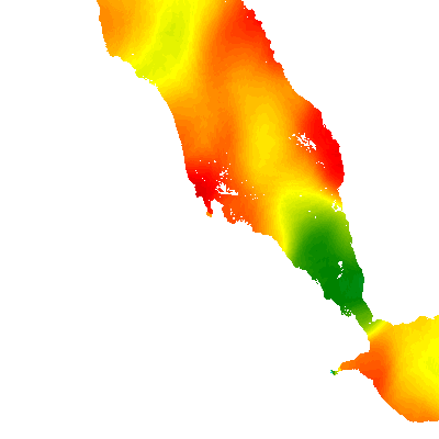
A second wind mapping effort utilizes microwave satellite scatterometry
data from the TOPEX and ERS satellites available from Colorado Center
for Astrodynamics Research at:
http://www-ccar.colorado.edu/~realtime/global_data_winds/wind.html
For this data the satellites measure the scattering of microwaves
from a rough sea surface and infer from the scattering the strength
and direction of the sea surface winds:
"A scatterometer works by sending a beam of microwave radiation toward the ocean surface at an angle. The beam, which passes undisturbed through clouds, gets scattered by the ocean surface, and some of the microwaves bounce back toward the satellite. A rougher ocean surface, which indicates higher winds, will reflect more radiation back toward the satellite than a smooth surface will."
(from: http://science.nasa.gov/headlines/y2000/ast11sep_1.htm)
We take the available scatterometry data, and perform a gaussian-weighted
geographic smoothing of this data like we did with the COADS data. The
result of this analysis is shown in figure 2.
| 0 | 2 | 4 | 6 | 8 | 10 | 12 | 14 |
The scatterometry data shows the jet-like shape of the high wind region with greater definition. The high winds in the Red Sea near Aseb are produced by the acceleration of the air in the lower marine layer as it flows from the Gulf of Aden to the Red Sea. This jet is at its strongest in the late afternoon and evening, and is at its weakest in the early morning. The strongest part of the jet extends from near the Djibouti border north to the waters just off of Idi, but it weakens as one proceeds from Idi to Tio. Proceeding North, the Massawa area is in a fairly low wind area of the coast with winds still fairly low as on proceeds north, but the winds intensify near the Sudanese border and the area around Port Sudan.
The mapping of solar energy resources, cloudiness, and sunshine is important for solar energy assessment, agricultural assessment, hydrological resource estimation and ecological modeling applications.
Solar resource assessment is a fairly straightforward application of remote sensing analysis. Cloud reflectance is detected in visible band satellite images, and the comparison of clear sky images and images with clouds can be used to estimate the approximate fraction of radiation reflected by clouds. The remaining radiation is assumed to reach the ground. With a fairly small sampling of stations a correlation relationship is derived between the measured solar radiation and the satellite-based cloud reflectance. We then use this relationship to estimate solar radiation for all of Eritrea and the surrounding area.
We have performed this solar radiation mapping exercise using 1995/6
Meteosat images and solar radiation measurements from a series of
first class meteorological stations maintained by the Eritrean Department
of Water Resources. The results of this mapping effort are
illustrated in figure 3:
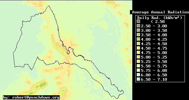
Figure 3: A annual average solar radiation intensity as estimated
using Meteosat satellite images.
In addition we have performed a series of monthly rainfall distribution estimates using correlations with vegetation response and elevation. The results of the vegetation-based rainfall estimates are available at: http://www.punchdown.org/rvb/rain/rainall.html
Because the monthly rainfall maps are produced from satellite images of vegetation, they actually measure the "effective" rainfall from rainfall, natural irrigation, and human irrigation. Irrigated areas are fairly small in Eritrea, so for most areas this is dominated by rainfall, but there are substantial areas of green in Sudan where the apparent rainfall is actually due to irrigation.
Further development of water and hydrological resources information will involve three major tasks:
For us task #1 is well within grasp, but the latter two tasks are long-term project development goals.
There are several refinements that we have planned for this data. First, we hope to produce a geomorphological refinement of the 1 km data in order to produce interpolated modeled data at about 100 meter resolution. This is done by producing a geomorphological model of the landscape and calculating that 100 m resolution landscape that is the most stable with regards to landscape evolution that is also consistent with the 1 km resolution data. Such a geomorphological model can also provide rough estimates of sediment transport and erosion rates that are also useful pieces of additional information. With regards to forecasting and resources policy analysis, a geomorphological model can also examine the connection between land use changes, erosion, and sediment transport.
With regards to soils and geological data, we as yet have no particular expertise or capability developed on this topic. But with access to some elementary soils and geological data we can use our satellite image archives and data processing capabilities to undertake some mapping projects.
There is a substantial potential for developing a highly useful and successful information system for marine resources and marine environment applications. The Marine Resources Department has made very good progress in this regard, and the efforts that we have made in this regard complement the existing efforts. Some of the information products for which there has been significant work already include:
The various resources that are available for the development of the marine resources and environment component of a climate and resources information system include:
The most accurate and high-resolution method for mapping sea surface temperatures in the Red Sea is through the use of AVHRR satellite images that can detect the radiated heat from the surface of the Red Sea. In the future, we hope to develop a system of archiving, processing and providing user access to such image data. But to date, we have utilized ship-based measurements from the COADS to produce a collection of monthly average sea surface temperature maps that are available over the Internet at: http://www.punchdown.org/rvb/temps/RSTssindex.html
There exists limited sea surface current data available in COADS. But we have yet to fully process this data and estimate sea surface currents. We believe that the primary drivers for Red Sea Surface currents will be the wind patterns over the Red Sea. We believe therefore that the best method for estimating Red Sea surface currents is through a combination of meteorological modeling and real-time sea surface temperature monitoring. The combination of surface measurements, satellite measurements, and dynamical simulations holds the prospect of providing a detailed real-time picture of Red Sea currents.
The Sea-viewing Wide Field-of-view Sensor (SeaWIFS) provides the prospect of monitoring ocean chlorophyll in the Red Sea at a resolution of approximately 8-16 kilometers. Ocean chlorophyll is related to plankton biomass production and ocean ecosystem productivity. To this end we have been archiving daily the SeaWIFS images for the South Red Sea since January 2000. There is only about one image per day and often the images do not have a clear view of the surface of the Red Sea, but the images do hold the prospect of understanding currents, plankton distributions and plankton production better. With further processing and analysis we hope to be able to produce some useful sea surface color products in addition to those available at the SeaWIFS site.
These different information system elements can also be classified as parts of four project development phases or tasks:
A fully volunteer effort at building a base of climate and resources information has made substantial progress to date. Fairly detailed maps (10 km to 1 km resolution) have been produced for temperature, solar radiation, Red Sea winds, average monthly sea surface temperatures, biomass production, and rainfall. In addition, systems have been set up for automated download, processing and analysis of publicly available satellite images and data. These information maps and systems will be improved over the next several years through the development of the following information system components:
In addition to domestic applications, the capability of producing climate and resource information systems is a highly valuable export commodity that Eritrea could market to other African countries. Technical studies and support are a major component of much foriegn development assistance to Africa. And if Eritrea and Eritrean professionals can become experts at African climate and resources information services, they hold the prospect of competing with developed world providers who charge very high prices.
Aggregate economic efficiency and productivity depends crucially on timely and accurate information. And small relative improvements in aggregate economic efficiency can have very large impacts on economic growth and production. We believe, therefore, that the development of efficient, accurate, and high quality climate and resources information systems is a strategically important component of Eritrea's national development process. As such, it deserves the experimentation, exploration, and innovation by many participants and professionals. We are in the process of developing an open and transparent integrated Internet-based climate and resources information system that we hope will contribute to the national development project, and we look forward to cooperation and collaboration with our colleagues in Eritrea and abroad. With such cooperation, we will collectively produce the high quality, efficient information system that the Eritrean people deserve.
Davenport, M.L. & Nicholson, S.E., On the relation between rainfall
and the normalized difference vegetation index for diverse vegetation types
in East Africa, Int. J. Remote Sensing, 1993, VOL.14, NO.12,
2369-2389, Taylor & Francis Ltd
Prince, S.D., Satellite remote sensing of primary production: Comparison of results for Sahelian grasslands 1981-1988, Int .J. Remote Sensing, 1991, VOL.12, NO.6,1301-1311, Taylor & Francis Ltd.
Nicholson, Sharon E., Davenport, Michael L & Malo, Ada R., A comparison of the vegetation response to rainfall in the Sahel and East Africa, using Normalized Difference Vegetation Index from NOAA AVHRR, Climate Change, 17, 1990, 209-241, Kluwer Academic Publishers.
Snijders, F.L., Rainfall monitoring based on Meteosat data- A comparison of techniques applied to the western Sahel, Int. J. Remote Sensing, 1991, VOL.12, NO.6,1331-1347, Taylor & Francis Ltd
Woldu, Tamrat, Remote sensing of Biomass Production, Radiation
Distributions, and Rainfall Patterns, Senior Thesis, University
of Asmara, June 1997, URL: http://www.punchdown.org/rvb/remote/tamrat.html