 (1)
(1)Program Authorized
to Offer Degree
Date
General Comment...a little sparse in topic sentences...
I will try to go through and present topic and transitional sentences in
italics.
INTRODUCTION *
PROBLEM STATEMENT *
Comment: discusses motivation....good.
BACKGROUND *
Wind Modeling *
Advantages and Disadvantages of Wind Power *
Power management and Integration *
Environmental Issues *
Economics *
Production, Installation and Maintenance *
Political Issues *
Wind Power Economics in Eritrea *
Variability in turbine costs *
Land costs *
Financing charges on loans *
Operation and Maintenance *
The Eritrean Energy Sector *
Wind Patterns *
Southern Coastline and Aseb *
Preliminary wind speed analysis for Aseb and the Red Sea *
Eritrean Coastline *
Projected available wind power *
Wind Direction *
Method Summary *
Limitations of Analysis *
Sources of Bias *
Rough Cost Estimate for Aseb Project *
Problems *
Recommendations *
Improve Aseb power system *
Pilot projects *
Economic assessment of wind power *
Utility and Government Planning of Wind Development *
BIBLIOGRAPHY *
APPENDIX A: Data resources *
APPENDIX B: CONCURRENT WIND PROSPECTING EFFORTS *
APPENDIX C: PRELIMINARY SPOT MEASUREMENT RESULTS *
INTRODUCTION
Because of the massive global environmental impacts of fossil fuel use, it is necessary to find ways to economically utilize non-polluting forms of energy such as wind.
The burning of fossil fuels is the predominant anthropogenic source of air pollutants worldwide. Carbon dioxide, sulfur and nitrogen oxides are threatening not only to those in the immediate vicinity, but also to the health of the global ecosystem. The Intergovernmental Panel on Climate Change has issued reports indicating that global warming is occurring, and that it poses a significant threat to human and other biotic systems. These findings fueled progress toward a legally binding international agreement to reduce emissions. (Add a sentence in Kyoto).
Developing countries, which need to improve their standards of living, cannot do so without increasing energy consumption. However, if all countries consume energy at the per-capita rate of developed countries such as the United States and Japan, worldwide carbon dioxide emissions alone would increase more than five-fold. Clean energy sources, such as wind power, could be an important step in avoiding such a situation.
As part of its plans for rapid expansion of the energy sector, the Eritrean Department of Energy is currently investigating the availability and suitability of a variety of power sources needed to rebuild the Eritrean infrastructure after several decades of civil war. In particular, power is needed in the central highlands surrounding the capital city of Asmera where about half of the Eritrean population lives. This project was undertaken to supply the Eritrean Department of Energy with information about wind resources in Eritrea, so that wind energy could be properly considered in the mix of Eritrea's energy development options.
Some previous, very introductory studies of wind resources in the vacinity of Eritrea do exist. Mulugetta and Drake (1996) conducted a study of wind potential for Ethiopia, Djibouti, and Eritrea. Their results indicate the highest potential for wind development along the Eritrean coastline. Other studies of the region surrounding the Red Sea and Gulf of Aden have also issued promising results for coastal areas (Elliott & Renne 1987; Pallabazzer & Gabow 1991; Radwan 1987). But none of these studies provided much detail or specificity with regards to the suitability of the wind resource for large-scale development.
This study provides a more detailed account of the wind potential in Eritrea and discusses the feasibility of wind power integration at the southern Eritrean port city of Aseb. In addition, this thesis attempts to advance the understanding of Eritreas wind energy resources in order to assist development in that country.
To do this, we first define the problem at hand, and then proceed to provide detailed background information on the history, benefits, challenges, economics and technology of wind energy. We then continue with the evaluation of Eritreas resource in particular. To evaluate Eritreas resource, we present a review of available data, discuss the methods we apply to analyzing that data, and present our results. We conclude with a discussion of the implication of these results for Eritrean wind energy development and present a series of recommendations with regards to the next steps to take in Eritreas wind energy development program.
While wind energy has been in use for millenia, it is only in the
last century that it has been used to generate electricity, and only in
the last couple of decades, that it has been economical for utilitity scale
electricity generation.
In the early 1900s, Denmark led the world in generating the first
wind powered electricity (Golob & Brus 1993). Since that time, great
gains have been made in the efficiency and reliability of wind turbines.
Wind is now economically competitive with both coal and oil, and could
meet 20% or more of the worlds electricity demand within the next four
to five decades (Grubb & Meyer 1993). Currently, wind currently contributes
less than one percent of electricity production worldwide (Gipe 1991)
but its gross production is rapidly increasing.
One factor which inhibits the widespread use of wind power is the difficulty encountered in selecting promising sites. This is because the economics of wind energy development depends sensitively on the nature of the resource. This means that a fairly large initial investment in studies and investigations needs to be made for wind energy, and that the uncertainties in the wind resource can add an element of risk to wind energy developments.
Since the 1970s, pioneering teams in the United States and Denmark have made significant progress in site selection and resource evaluation techniques. There is, however, no universal model. Because wind potential assessments are site specific, they tend to be very time consuming and costly. This makes wind power unattractive for most developing countries, whose economic situations force them to find the most inexpensive and expedient means of energy production available.
This thesis hopes to help break down some of these wind energy development barriers for the particular African country of Eritrea. We do this by investing time and expertise in a more detail, abiet still preliminary, evaluation and analysis of Eritrean wind data.
As in introduction to our study, we provide a fairly detailed background on the current status of wind power, and the advantages and disadvantages of wind. We also provide a basic description of wind turbine technology, and wind development economics. Finally, we discuss wind energy assessment methods in general before moving on to the country-specific component of our study.
History and Current Status of Wind Power
In the past two decades, utility-scale wind power has been transformed from an expensive alternative energy technology into an economically viable, mature energy option. Installed wind capacity worldwide has increased from 10 megawatts in 1980 to nearly 5 gigawatts by the end of 1995 (See Figure 1: World Wind Capacity). This exponential growth in wind capacity was spurred by large reductions in the real cost of wind power.
With an estimated cost for new installations of between 4 and 7 cents per kilowatt/hour at suitable sites, wind is now cost competitive with installed power from most energy sources. This cost is expected to be even lower a decade from now (Swezey & Wan 1995). However, new fossil-fuel technologies have also lowered the cost of new power generated with natural gas or gasified coal. Cost estimates for new combined-cycle natural gas generation are as low as 2.5 cents per kilowatt/hour, forcing the wind industry to lower its target generation costs once again.
It is important to note that the cost estimates given above apply to countries with an installed infrastructure for coal and natural gas, which Eritrea does not have. Furthermore, although fossil-fuel power generated with combined cycle technology is less damaging to the environment than conventional generation from fossil fuels, it is far more damaging than wind power. Therefore, these costs reflect neither the environmental or public health damage from emissions of carbon dioxide and volatile organic compounds. In addition, wind power decommissioning costs, ultimately paid by society, are low compared to decommissioning costs for other sources, especially nuclear power.
Early development of modern utility-scale wind machines occurred primarily in California, spurred by state and federal tax credits and concern for the environment. Up until 1994, California still maintained over half of the world's utility scale wind power. By 1995, 22 countries possessed more than 1 MW of installed capacity (See Table I: Installed World Wind Capacity by Country, 1980-1995 and Figure 4: Percentage of world wind capacity by country), with Europe holding just over 50% of the total (IEA 1996). Of the wind power capacity installed in Europe, nearly 90% was located in only four countries: Germany, Denmark, the Netherlands, and the United Kingdom.
Recently, a booming market has materialized in Asia, particularly in India, and to a lesser extent, in China. Although the 340 MW of new capacity installed in Asia in 1995 represented an enormous fractional increase of 160% in one year, the absolute increase was dwarfed by European additions of 781 MW (Anonymous 1996). The majority of Asia's current installed capacity is in India. A number of analysts are concerned that the development in India may be too rapid to ensure that an adequate institutional structure is in place to protect the long term stable development of the industry.
While the European and Asian markets have been booming, the US market has been declining for several years. This decline has been attributed to various factors including a sharp fall in wind energy purchase prices in California, after the termination of many 10-year power contracts signed in the early 1980's. Energy purchase prices have dropped from over $0.10 per kilowatt-hour to below $0.03 per Kilowatt-hour. For some wind plants this resulted in a sudden 80% reduction in wind energy sales revenues. These low revenue levels that could not justify new investments, and even made it economically unjustifiable to replace old equipment. This has resulted in a large number of used and refurbished wind machines being available for relatively low prices. The net effect of the great instability in the California and US markets has been punishing for US wind turbine manufacturers and wind power companies.
Although the rapid growth in the European market is expected to slow soon as public objections to wind machine appearance and noise grow [Garrad 1996], the growth in the Asian Market is expected to remain strong. The number of recent wind energy assessments for lands near the Mediterranean and Red Sea alone suggests growing interest among many smaller energy consumers in the region (Radhwan ; Habali et al., 1987; NREA 1989; Pallabazzer & Gabow 1991; Katsoulis & Metaxas 1992; Katsoulis 1993; Haralambopoulos 1995; Incecik & Erdogmus 1995; Pashardes & Christofides 1995; Tolun et al. 1995; Turksoy 1995).
Advantages and Disadvantages of Wind Power
The materials and technologies required for using wind as an energy source differ considerably from those used in traditional energy sources. In determining the suitability of the large-scale use of wind energy for a given region, the costs and benefits of the technology must be carefully weighed. This section discusses the issues that must be taken into account when considering the development of wind as an energy source. We describe qualitatively the factors influencing the costs and benefits of wind power below.
Traditional fuels such as coal and oil, are found only in limited geographical areas. These fuels can be harvested, processed, shipped, stored and used as needed. This allows production of energy whenever and wherever the demand exists.
Good wind resources are much more widely distributed over the earth's surface than traditional fuels and are essentially inexhaustible. A major liability, however, is that the resource itself cannot be stored or shipped. After conversion to electricity wind- generated energy can be stored several ways. (See section on storage, below.)
Power management and Integration
Even in best sites, the wind does not blow continuously. Although wind power sometimes parallels demand, the correlation is unlikely to be perfect. Because of this, wind cannot generate 100% of electricity demand without substantial storage capacity, which can be costly. A high (>35%) percentage of wind capacity connected to a system decreases the reliability of the system due to the addition of the intermittent wind resource. Large-scale systems at low wind penetration create fewer problems for wind integration than those with higher penetration. In most systems, wind should be able to contribute from 25 to 45% of the total electricity before operational losses become prohibitive, even in the absence of storage [Grubb, 1993].
If the installed wind capacity is larger than this, then the intermittence problem may be reduced by having many wind turbines spread out among different sites in different wind regimes. This will smooth the overall output. In addition, if energy demand is not well correlated with the timing of wind supply, financial incentives can be used to shift demand to periods of larger wind power supply. Alternatively, back-up power systems and/or storage facilities can be installed.
Storage. For utility scale applications, storage issues will usually arise when more than 30% of the energy supplied is from intermittent renewables (Grubb & Meyer 1993). Below this level the supplied energy provides a variable, negative load, and as such reduces the fuel consumption requirements on the other generators in the system.
Since wind power is an intermittent energy source, some method of storing energy is desirable for high wind penetration systems to ensure adequate supply during peak consumption. At present, such storage may be too costly for large-scale projects. Batteries are the simplest method of storing smaller amounts of energy, but these can be large and expensive. Other possible methods include using excess energy to pump water from a low reservoir to a high reservoir during times of low demand, and then allowing the water to flow back down through a turbine to generate electricity when it is needed. Storing excess energy as compressed air in subterranean chambers has also been shown to be feasible, and may be less costly than storage using the elevation of water (Cavallo, 1994). Other possibilities for future utility-scale wind generation include fly-wheel storage (for short term variations) or chemical energy storage in the form of hydrogen fuels. The latter may be a particularly promising application for coastal wind plants in the long-term future.
Back-up Systems and Additional Power Generation. Another solution to the intermittence of wind energy is the installation of additional power sources, either as backup systems or to work in conjunction with the wind system. This increased diversity increases system reliability considerably. Consistency is best improved through the use of hydropower generators and gas turbines when available. Because they can be quickly turned on and off in response to wind power fluctuations. Diesel generators can also be run when wind velocity is low and stored electricity is not available, but their response time is not as quick as hydropower and gas turbines.
Compared to most other sources of energy, wind energy is environmentally benign. No air pollutants, radioactive materials or any hazardous substances result from the production or use of wind turbines. That is not to say, however, that wind energy does not have any negative qualities. Following is a list of negative environmental impacts commonly associated with wind farms.
Land requirement. Because of the nature of wind, many machines must be installed to intercept a large amount of power. In addition, these machines must be spread out over a large area, to ensure that the turbines do not interfere with each other. Turbines in large wind farms are typically separated by 5 to 10 rotor diameters, each turbine occupying an area of about 50 square diameters of land. Although these requirements seem demanding at first glance, they actually compare favorably with land requirements for coal or nuclear generation when the full life-cycle requirements of mining, processing, transportation, and waste disposal are considered.
Field studies in California indicate that wind projects occupy about 7.1 hectares (0.071 square kilometers) per megawatt (Gipe 1991). Using these figures, a wind farm which produces power at the rate of an average nuclear power plant (about 1 gigawatt) may require an area of over 70 square kilometers. However, since only about 10% of this area is actually occupied by the turbine base and access roads, the remainder can be used for farming or grazing.
Visual impact. Because wind turbines are typically between 30 and 50 meters in height, a significant impact of a large number of turbines in an open area is unavoidable. However, the effect of the turbines presence is subjective and opinions vary widely. Surveys have shown that uniformity of size and spacing improves aesthetic acceptability considerably (Clarke, 1991). In addition, tolerance of other large structures such as pylons, utility towers and telephone poles suggests that negative opinions may be more a matter of habituation than the appearance of the objects involved.
Noise. Noise created by gearboxes and blades can be a problem in densely populated areas, and can limit settlement within audible range. This issue has received considerable focus in densely populated Europe where wind development has been very rapid in recent years. Recent studies show that the use of large wind turbines over medium sized turbines limits noise output per watt, but these large machines have many other drawbacks (See Background: Wind Turbine Technology). Although people do not generally choose to settle in areas with unusually high wind speeds anyway, care should be taken to ensure a distance of several hundred meters between the turbines and the nearest habitation for both noise and safety reasons.
Electromagnetic interference. To avoid problems of interference with vital radio transmission services such as aircraft navigation systems, the relative locations of such facilities and wind turbines should be studied carefully. Where potential for problems exists, careful choice of turbine design and materials can reduce radio interference. Optionally, a booster receiver/transmitter can be installed at the facility.
Wildlife disturbance. At this point, birds seem to be the only wildlife adversely affected by wind turbines, and even this disturbance is rarely a problem. Studies show that, in most cases, the effect is negligible under conditions of good visibility. In fact, studies in the United States and Europe indicate that bird deaths attributable to collisions with wind turbine rotors are significantly lower than deaths from collisions with motor vehicles and windows. At Altamont Pass in California, however, bird strikes occur at a rate of about one per month, which is often enough to raise concerns over the issue. This problem can be limited by avoiding known bird migration routes, and perhaps more importantly, locations of known rare and endangered species. Considerable research is underway on rotor and tower modifications that might be used to limit the disturbance.
Recent studies by the California Energy Commission (CEC), the Electric Power Research Institute (EPRI) and Pacific Gas & Electric (PG&E) confirm the wind industrys claims that wind has become competitive with conventional energy sources. When social and environmental costs are included in the price comparison, oil combustion, nuclear fission, and coal are among the highest cost, whereas efficiency, wind, and biomass are among the lowest-cost technologies (See Table 2).
Optimal conditions for the economical development of wind power include high wind speeds, low interest rates, and low labor costs. Due to the high capital costs associated with wind development, no country has successfully built up a wind generation industry without subsidies. At over $1,000 per installed kilowatt, high capital costs can be a real problem when such capital or loans are not available, or where interest rates are high. Because wind power is a clean energy source, loan subsidies may be obtained from industrialized countries to help in financing development.
The relatively low cost of decommissioning of a wind power plant is one of its often unaccounted for economic advantages. Decommissioning costs for a medium-sized wind turbine is estimated by the US Bureau of Land management at about $50 per kilowatt (Gipe, 1995). In addition, the wind decommissioning costs cited here may be overestimated by not taking into account the fact that older turbines can be replaced by modern turbines at the end of their useful lives, reusing the tower and platforms, as well as recycling many of the other parts.
Finally, unlike many other capital-intensive energy technologies, such as solar or geothermal, wind plants require a fair amount of labor. According to the Worldwatch Institute, results from California indicate that wind is the most labor intensive of the energy technologies it examined. This is a disadvantage in that it implies a fairly intensive maintenance and operation routine is required. In Eritrea, however, it may be beneficial because labor costs are low. Maintenance and operation may cost less in Eritrea and provide additional employment.
As industrialized countries realize the potential threat of climate change due to the burning of fossil fuels, capital funds for wind investments may be available at reduced rates. Especially since the supply and demand for energy in the Lesser Developed Countries (LDC's) is expected to increase rapidly. Countries with limited capital will seek energy supplies with low capital requirements, typically petroleum products. This will require that the industrialized countries reduce their own carbon emissions to offset the increasing emissions from the LDC's. One strategy to control carbon dioxide emissions is to provide a moderate subsidy for investments in renewable energy supplies in LDC's. The most economical large scale renewables with no carbon emissions are hydro and wind power. Thus as carbon dioxide emissions become a greater problem, it becomes economical to provide greater subsidies to hydro and wind power developments. These subsidies will probably be provided in the form of low-interest loans or grants.
Production, Installation and Maintenance
One of the main benefits of wind power over conventional electricity generation is the comparative ease with which turbines are set up and maintained. Since wind machines are pre-manufactured, installation is relatively quick and straightforward once a site has been chosen. Another advantage is that wind farms are extremely scaleable, with one, ten, hundreds or even thousands of machines. Because of this inherent modularity, increasing or decreasing capacity as needed does not require the outlay of unnecessarily large capital expenditures at any one time. Also, wind systems can continue generating electricity even when one or more machines are down for maintenance. Although new combined-cycle gas generation offers similar benefits of modularity, conventional large-scale power plants have to be built on-site, requiring years of planning and building, and cannot produce power during periods of maintenance or repair.
Regular maintenance can be carried out by the on-site operator, but visits which require parts or all of the turbine to be lowered to the ground may require assistance. Thorough maintenance checks should be made at least once per year, but more frequent visits are recommended, especially before and after severe weather conditions. Maintaining a log of the condition of fasteners and any corrosion is recommended, especially in coastal areas where salt and moisture can be especially corrosive.
For more remote populations, roads from larger cities to remote villages may need to be built or improved. Larger wind machines must be delivered by truck, and future maintenance may require roadways also. Of course, small wind machines may be delivered to remote locations by helicopter or airplane, in which case roads would be unnecessary. A telephone or some other method of communication should be available.
Wind energy as an indigenous resource provides the political advantage of decreased dependency on foreign fuel imports. But as a capital-intensive technology, it may make a country like Eritrea dependent on the acquisition of foreign financing.
Wind power technology has improved dramatically over time. Modern wind turbines are 10 times more efficient at capturing the wind's power than the early Dutch windmills with the same rotor diameter (Gipe 1995). In more recent history, the capacity factors of California's wind farms have almost doubled between 1987 and 1990, from an average of 13% to 24% (Cavallo et al., 1993).
Wind turbines may be categorized into four size ranges as follows:
In addition to wind turbines, which by definition generate electricity, there are also mechanical wind systems used primarily for pumping water. In 1993, there were more than one million wind pumps estimated to be operating worldwide, with an equivalent capacity of over 250 megawatts. This Eritrean wind study focuses on wind electric potential, primarily at the small and medium scales. However, there may be useful applications for microturbines displacing high-cost photovoltaic power in village settings. In the Eritrean context, low-head water pumps are unlikely to be popular because installation would require monetary charges for an activity that is normally carried out by "free" labor. Thus, this option is not currently being pursued.
Most of the early development of modern utility-scale wind machines occurred in California in the late 1970s and early 1980s. Early experiments with multi-megawatt machines failed, leaving most of the successful machines in the field below the 200 kilowatt range. In the U.S. recently, the trend has been toward somewhat larger machines, capable of providing 300 to 500 kilowatts of electrical power. In Europe, due in part to the lack of abundant and inexpensive land, there has been a long-term commitment to even larger turbines. This interest waned briefly in the first half of the 1990's, but has picked up again in recent years (Garrad 1996). These larger machines, in both the U.S. and in Europe, tend to be considerably more complicated than their smaller counterparts.
Wind turbines may have either a horizontal or a vertical axis. Most modern machines have a horizontal axis and two or three blades. Being symmetric about the vertical axis while spinning, the turbine of vertical axis machines is insensitive to changes in horizontal wind speed direction. In contrast, horizontal axis wind turbines (HAWT), must have the plane of the rotor perpendicular to the wind to capture its power. Modern HAWT systems are therefore designed so that the horizontal axis can rotate about the vertical axis of the tower on which it is mounted. This rotation is referred to as "yawing".
Wind machines may yaw passively or actively. In passive-yaw machines the rotor aligns itself downwind of the tower. In active-yaw systems, the turbine is computer controlled to always face into the wind. These systems are therefore referred to as downwind or upwind systems, respectively. The justification for the additional cost and complexity of the upwind systems is the avoidance of power-reducing turbulence downwind of the tower.
Another new option in wind machines, allowed by the current sophistication and reduced cost of electronics, is the variable-speed generator, which generates electricity at variable rotor rotation speeds. The argument for variable speed machines is that they can operate over a wider range of wind speeds, thereby increasing the capacity factor of the system and reducing costs. In addition, running the turbine at different speeds reduces the mechanical stresses on the rotor and drive train. It is hoped that this will increase the life span of the system. Now that there are field data available on variable speed machines, it is not clear that these gains have materialized (Milborrow 1996). Critics claim that, although the variable speed machines do generate power over a larger range of wind velocities, their capacity factors are reduced by low availability (because of repair and maintenance) and inability of the active-yaw system to track the wind rapidly enough given their enormous inertia. It is yet unclear whether these problems can be eliminated so that the full potential of this technology can be captured.
Another factor that varies among turbines is whether the pitch of the blades is fixed or variable. Altering the pitch of airfoil blades alters the relative lift and drag forces, thereby changing the amount of power a turbine extracts from the wind. Lift is increased to allow start up at lower wind speeds. Lift is decreased to protect the turbine in high winds and to provide aerodynamic rotor braking. Pitch control mechanisms experience very large forces at the blade-hub connection and thus must be carefully designed. Fixed-pitch blades, also known as stall-controlled blades, naturally lose lift in high winds when the laminar flow over the blade surface becomes separated and turbulent. Stall-controlled systems are attractive for their simplicity. Limitations include larger stress loads at high wind speeds than variable speed machines and the necessity for additional means of aerodynamic or mechanical braking (Cavallo et al. 1993).
For this study, it is important to determine which technologies are most appropriate in the Eritrean context. Choosing among the enormous diversity of machines could be a difficult task. Fortunately, there are factors that can be useful guides. Machines larger than 500 kilowatts are likely to be unsuitable for a number of reasons. First, their large size makes them unsuitable for transportation on small roads. A 500 kilowatt turbine has a rotor diameter of about 35 meters, compared to a rotor diameter of only about 18 meters for a 100 kilowatt turbine. Similarly, installation of the larger machines requires the availability of very large cranes. Finally, the use of the new variable speed machines seems imprudent at this point given their limited field experience and their relatively unimpressive performance to date. In general, it appears prudent to opt for the medium sized machines between 80 and 200 kilowatts, with simpler technologies and longer field experience. Variable pitch machines, although more complicated than fixed pitch machines, might be the exception since they have received considerable field experience. For example 22 of the 35 models of wind turbines in the Altamont Pass in 1992 are of variable pitch design.
When considering the purchase of individual machines, there are some compiled data available that should prove useful. Lynette (1989) performed a detailed evaluation of the operation and maintenance of 4,500 turbines installed in California between 1981 and 1987. Current information is available in quarterly reports entitled the "Wind Stats Newsletter" on the performance of 7000 individual turbines installed in 6 countries in Europe (Wind Stats Newsletter, Vrinners Hoved, 8420 Knebel, Denmark, Fax: +45 86 36 56 26, Tel: +45 86 36 59 00). The data for Denmark and Germany are available in digital form. In addition, the California Energy Commission compiles data on turbine performance from field experience in California.
Wind Power Economics in Eritrea
Various factors could effect the price of wind power. Most important among them are possible variations in the cost of turbines, land, financing charges on loans (for large projects), labor, and need for new transmission lines. It is also always true that the cost of wind power produced is very sensitive to the average wind speed at the installation. All of these other factors can vary significantly and are discussed individually below. The approximate distribution of the costs of the different components of a wind generation facility are described in the following tables:
Installation Costs for 50MW Wind Farm
(1995 installation year)
Component Unit cost (1992$/kW)*
Wind turbine 888
Substation 68
Transmission 6
Service Center 5
Land 40
Indirect/Permitting 26
Total 1032
Source: Brower, 1993; Gipe, 1995
*Costs assume a 10.5% financing charge.
Installation Expenses for Danish and California Wind Plants
(% of Total Costs)
Zond ELSAM
Turbines 73 68
Foundation 4 9
Installation 4
Roads 3 2
Electrical 10 8
Grid Connection 4 6
Land 3
Control Building 1
Miscellaneous 2 3
The turbine cost is the largest portion of project cost, and fortunately is probably the least uncertain of the component costs. It can be fairly well predicted for a given project. All of these other factors could vary considerably in the Eritrean context and are discussed individually below.
The Effect of Wind speed on Cost
Because the power in the wind is proportional to the cube of the velocity, the cost must depend significantly on the average wind speed. Because both the capacity factor and the average annual power output depend upon the nature of the hourly wind speed distribution over the year, the relationship between cost and average annual wind speed can only be approximate. Figure 6 shows the effect of changes in the average annual wind speed on the cost of wind power using the Mod-5B Horizontal Wind Turbine [Spera, 1995] . This figure illustrates the importance of having an accurate wind resource characterization before investing in a wind power plant. An overestimation in the average annual wind speed of 1 m/s could increase the cost by 40%.
Generally, the turbine costs will be the best known factor. They are important however because (at least in Europe and the US) turbines typically comprise more than 70% of the total installation costs and wind plants [Brower et al., 1993; Gipe, 1995 ] . In California at times the price charged for the same machine has varied by as much as 80% for machines installed at about the same time in sites with different wind potential (the better the winds commanding a higher premium). Thus, prices for wind machines may be determined individually for each transaction by the market in a somewhat capricious manner.
Another factor that could change the cost per installed watt is the size and type of the wind machine chosen. Prices quoted above were based on approximate averages of US and European experience. The trends in US and European wind machines has been and continues to be toward larger and more complicated machines (>500 W) (variable-speed, upwind machines). These were anticipated to result in substantial cost reductions relative to their simpler single-speed, downwind counterparts, due to economies of scale and because of increases in capacity factors anticipated to accrue from being able to operate over a wider range of wind speeds. Now that there is field-data to analyze, however, it is not clear that those gains have materialized Milborrow, 1996 #20 . Critics claim that, although the variable speed machines can indeed generate over a larger range of wind velocities, their capacity factor is reduced by low availability (repair and maintenance) and inability of the active-yaw system to track the wind rapidly enough given their enormous inertia.
These larger more complicated machines may well not be appropriate in the Eritrean context. Transportation and installation requirements are more demanding and costly, requiring larger cranes and larger and better highways, and greater technical expertise. Furthermore, for smaller plant capacities, smaller (100 - 200 kilowatt) machines are more appropriate since they can offer redundancy by incorporating a larger number of machines thereby reducing output variability if one machine is out of service. These simpler systems may also require less maintenance.
An important question is whether these smaller machines will have higher installed costs because of the lost opportunity of economies of scale? The following data from Gipe (1995), organized only by size of machine, suggest there will be little cost compromise from using smaller machines.
Typical Wind System Installed Cost
Rotor diameter (m) kW Approx. installed cost $/W
Microturbines
1 0.25 $2,500 $10.00
2 0.75 $5,000 $6.67
Small Turbines
3 1.5 $10,000 $6.67
7 10 $30,000 $3.00
Medium-Sized Turbines
18 100 $125,000 $1.25
25 200 $250,000 $1.25
35 400 $500,000 $1.25
40 500 $600,000 $1.20
Although economies of scale are clearly apparent in the microturbines and small turbines, at about 100 kilowatt these economies of scale fall off, so that the smaller medium-sized turbines produce almost as cost-effectively as their large cousins. Furthermore, Gipe (1995) cites many individual examples of German wind turbines for which the price per kilowatt is actually less for the smaller turbines (80 - 100 kilowatt) than for their larger 450 - 500 kilowatt counterparts. Production and field data are not available for the new generation of 1MW and larger machines being designed in Europe. Therefore, no relevant cost comparisons can currently be made.
Data suggest that land costs, have not been an enormous contributor to the price of wind-energy in the US. In Altamont pass land rental is paid as a fixed 4% of the price of electricity generated. From the data in the tables above, land costs were less than 5% of installation costs. Therefore, we can conclude that energy-costs savings from likely low land costs in Eritrea will not offer a very substantial savings relative to current costs estimates based on US and European experience.
Financing charges can vary substantially. Gipe (1995) reports a range of financing rates form 3.3%/yr in Germany to 10.1%/yr in Great Britain. Financing charges on wind projects for private utilities in California was reported as 10.5%/yr (Brower et al.1993). The far extreme is the possibility of interest free loans or grants to develop small projects. Since approximately 80% of wind generation costs are capital costs, financing rates will have the biggest impact on wind energy development costs in Eritrea. Loan repayment costs depend on both the interest rate and the project lifetime. The present value or effective cost of the loan repayment also depends on the rate of inflation: the higher the rate of inflation the lower the present value of the loan repayment costs.
We summarize the effect of interest rate and project lifetime on loan repayment costs in the following table. These calculations assume an inflation rate of 0%, and provide results in terms of loan repayment costs per kilowatt-hour of wind electricity produced. The calculation assumes that the capital costs of project equipment, installation and land acquisition are $1200 per kilowatt-hour, and that the capacity factor for the wind turbines is 0.28.
Repayment Cost ($/kWh)
Project Life
Interest Rate 10 years
20 years
2%
0.054 0.030
3%
0.058 0.032
6%
0.066 0.042
10%
0.080 0.058
The final cost of energy will also depend on operation and maintenance costs. Operation and maintenance costs in California wind farms has been between 0.5 and 1.7 cents per kilowatt-hour, averaging around 1 cent per kilowatt-hour (this is about half the cost of operation, maintenance and fuel for nuclear and coal plants, and about one third of the cost of the same for gas plants). Costs are similar in Europe.
More research needs to be done to determine what fraction of US and European-based installation and operation and maintenance costs are from labor. Those costs, which are usually substantial in the US and Europe, should be lower in Eritrea, and might result in substantial cost savings. In addition any components, such as wind towers, that might be manufactured locally could further reduce costs. In the long-term, if manufacture and production of other wind turbine parts are localized, further cost reductions should accrue. Studying the cost breakdowns for the new wind developments in China and India will be instructive.
A wind energy assessment is an integrated analysis of the potential wind energy resources of a particular area. Such an assessment begins with an understanding of the general wind meteorology of the area, and progresses to the collection and analysis of what ever data may be available. At its most advanced stage, it may also involve a targeted monitoring program and meteorlogical computer simulations. In this study we focus on meteorological understanding, data collection, and analysis.
Wind is air that is moving relative to the ground due to large scale differences in air pressure, which are in turn caused by differential heating of the earths surface. On global, regional and local scales, these factors, in combination with topographical features, cause circulation patterns to exist. The wind researchers responsibility is to calculate and analyze wind patterns for use in determining wind resource potential. Most commonly, mean wind speeds are used as an indicator of wind production potential, where about 6 m/s winds at 10 meter hub height is considered economically viable.
The first step in a regional wind energy resource assessment is to determine which major wind flows contribute to the resource. On a planetary level, trade winds extend from the equator to about 30 degrees latitude in both hemispheres while westerly winds extend from about 30 to about 65 degrees latitude in both hemispheres. Monsoons are seasonal winds caused by large annual temperature differences over land and sea areas. Breezes are the mesoscale equivalent of a monsoon, lasting only a few hours, often on a daily basis. Synoptic scale winds are associated with periodic systems, typically spanning a period of about 3 to 5 days. Mesoscale wind systems are generally associated with topographical features, including physical and differential heating elements. All of these winds must be taken into account when estimating the wind potential for a given region (Aspliden et al. 1986).
The second step is to analyze observed data to determine the magnitude and duration of winds for each scale of motion. Depending on the region, wind resources can vary from year to year, seasonally, from day to day, diurnally, and even from minute to minute. Long-term means for wind speed and direction are most important for estimating power output at a given site. Seasonal and diurnal variations are important when considering peak demand and power supply. Variations of very fine temporal resolution, although necessary for choosing appropriate wind turbines, are beyond the scope of this study.
Due to friction at the earths surface, wind speeds are generally higher at higher elevations; therefore, wind speed measurements depend on the height at which they are observed. Typically, wind speeds are measured at 10 meters, the height recommended by the World Meteorological Organization. Since wind turbine hub heights tend to be above this level, extrapolation from available data is required to estimate wind potential at the planned hub height. Some methods commonly used to obtain this estimation are the power law model, the similarity model, and the logarithmic law model (Mikhail et al. 1986).
Because wind data must be accumulated for a period of a year or more to obtain reliable wind resource estimation, it is convenient for wind researchers to obtain data sets which have been previously recorded. There are several sources which may be helpful in obtaining wind and other meteorological data.
Meteorological and climatological stations as well as airports are likely to have reliable information. The World Meteorological Organization maintains a record of all stations worldwide at which meteorological observations are made. Some other helpful organizations are the National Climatic Data Center (NCDC), the National Oceanic and Atmospheric Association (NOAA), and the National Aeronautic and Space Administration (NASA).
For resource assessments conducted near coastal areas, wind information over the surface of the water may also be helpful. Observations made from ships and buoys can be obtained from NCDC. Scatterometer data from ERS-1 and SSM/I satellites are available from the Jet Propulsion Laboratory in Pasadena, California. One study comparing ERS-1 and SSM/I wind vector data with buoy wind measurements showed agreement to better than 2 m/s (Bentamy et al. 1995). However, one should take keep in mind that these estimates become highly unreliable within 50 to 100 km of the coast (Wentz 1992).
Many regions of the world, particularly poor and developing countries, have very scanty or intermittent meteorological data. Although there are mathematical methods for filling temporal gaps in scanty data (Barros 1986), supplementary measurements of wind speed and direction are recommended. Where additional measurements are feasible, the researcher can choose to monitor sites with the highest expected wind potential. Likely areas include (Aspliden et al. 1986):
Approaches to wind modeling depend on the nature of regional wind flows, the complexity of the terrain, and the availability of a dense network of meteorological monitoring stations. In regions with very simple terrain, predictable regional wind flows, and reasonably dense monitoring networks, wind maps may be generated using simple extrapolations of meteorological station data, such as was done in the wind assessment of Somalia (Pallabazzer & Gabow, 1991). For somewhat more complex terrain, station data may be extrapolated using meteorological models that account for the effect of topography on flow. Such models, including WAsP from RISOE in Denmark, are commercially available.
In Eritrea, thermally driven winds and extreme elevation changes disrupt regional wind flows. Under such conditions, locations only a few kilometers apart may show little or no correlation in wind speed and direction. Standard wind assessment methods are not well defined for such sites. Approaches in these regions range from applying meteorological intuition, given information on topography and regional wind flows, to using state-of-the-art mesoscale models employing the full set of non-linear equations of fluid dynamics.
Now that we have described, the history, advantages, technology,
economics, and assessement methods of wind energy development in general.
we will apply this understanding to the specific case of the East African
country of Eritrea in the next sections.
The feasibility and applicability of wind energy development depends
on the particular social, economic, and physical characteristics of both
the study area and the wind resource. In this section we begin with
a description of the particular country under consideration. We then
describe the geography, and demographics, the particular conditions of
Eritreas energy sector, and the general wind patterns in the area. We end
the section with a description of Eritrea's South Coast where the most
promising wind energy resource is located.
Eritrea is a small, relatively poor country in northeastern Africa.
Brief historical perspective.
Eritrea occupies the southernmost 1200 kilometers of the Red Sea's western shoreline, including hundreds of islands near the major ports of Mitsiwae in central Eritrea and Aseb in the south (see Figure 1). The capital of Asmera is located in central Eritrea on a plateau at over 2000 meters elevation. This high plateau and the surrounding hillsides are known as the central highlands. To the west and east are the western and coastal lowlands, respectively. The western lowlands consist chiefly of desert hills and savanna. To the east, the high plateau drops abruptly to a wide, arid coastal plain, which stretches the entire length of Eritrea. South of Mitsiwae, the coastal plain dips to 100 meters below sea level at the Danakil depression, which divides the central highlands in the west from a much smaller range of mountains in the east. This second range parallels the shoreline from the Danakil depression to beyond the Djibouti border, reaching almost 2000 meters at its highest point.
The population of Eritrea is estimated at 3.6 million. Of that number, roughly 20% inhabit the capital, Asmera, on the high plateau. Although accurate population counts for other major cities are not available, it is estimated that more than half of the Eritrean populace lives in the towns and cities of the highlands.
The Eritrean energy sector is characterized by a relatively low level of electricity supply, a reliance on biomass (especially in the household sector), and a large unsatisfied latent energy demand. Approximately 80% of energy consumption is biomass while 2% of consumption is electricity with the balance being liquid petroleum fuels (Government of Eritrea, 1995). Meanwhile, government energy policy is: a) promoting rapid expansion of the electricity supply, b) providing support for high-value isolated rural electricity supply for specific development projects, and c) promoting the replacement of biomass resources with alternative fuels.
Eritrea has an electric firm capacity of about 60 Megawatts and generates 144.6 GWh per year. The main national electric grid has a formal capacity of 40 megawatts. Transmission lines stretch from Mitsiwae to Asmera, and then continues south to Adi Quala for a combined length of about 500 kilometers (see Figure 1). A second grid, with a capacity of 17 megawatts, is located at Aseb. In practice, the actual generation capacity in Eritrea is approximately one half the formal generation capacity because many generators are old and inefficient. Actual electricity production increased at an annual rate of 10% from 1992 to 1995.
Virtually all electricity is generated with diesel and fuel oil with perhaps 100 kilowatt of solar electric capacity in remote areas. There exist both central generators in the 45 Megawatt Interconnected System (ICS) with the rest being generated in small to medium-sized towns which are part of the 15 MW Self-Contained System (SCS). The cost of electricity production in Eritrea is approximately Birr 0.45 or US$ 0.065. As much as 80% of the population is without electricity, and one of the national priorities is to expand electricity supply by at least 6% per year. From 1992 to 1995 actual electricity consumption has expanded at a rate of 10% per year. These expansions are occurring primarily through improvements and expansion of the ICS because the economies of scale will provide for greater efficiency in a central electrical grid. The Eritrean government has approved the construction of a 84 MW heavy fuel oil fired power plant which is expected to be completed at Hirghigo, near Mitsiwae in 1998. If Eritrea decides to invest in a wind electricity generating capacity, it could be used to provide a 10%-20% expansion of the electric supply after 1998.
In more isolated locations, there exist selected PV applications for systems of 3 kilowatt peak demand or less, while most larger applications use small-scale diesel generating units. The solar electric systems in these projects have a very high capital cost of over $7 per watt of peak capacity. Meanwhile, the diesel systems suffer from high operational costs and fuel supply problems. For those sites with good wind resources and for applications that can utilize intermittent electricity supply, wind generators may provide a more economical source of electricity with capital costs of $1-$4 per watt of peak generating capacity for systems in excess of 10 kilowatt capacity.
In the biomass sector, because of shortages and environmental degradation produced by the collection and use of biomass fuels, current national policy is to replace biomass use in the household energy sector with Liquefied Petroleum Gas (LPG) which is viewed as the most economical and desirable replacement fuel.
Wind patterns in the Red Sea region are controlled to a large extent by two distinct monsoons that are separated by 30 to 45 days each. The Northeast Monsoon dominates the southern half of the Red Sea from November to March. The African equatorial low centered at 10N 30E creates a strong southeast wind that is pulled through the narrow Bab el Mandeb at the southern mouth of the Red Sea. This wind slows as it continues toward Mitsiwae where it converges with the northwest wind. Much of this air mass is drawn southwestward across the Eritrean highlands toward the African equatorial low pressure system centered in southern Sudan. During the Southwest Monsoon from May to September, the warm Pakistani low formed at 30N 65E causes surface winds along the entire length of the Red Sea to blow from the northwest, down the length of the Red Sea, and out into the Gulf of Aden (US Navy, 1993).
During the winter season, temperatures in the Gulf of Aden tend to be lower than temperatures in the Red Sea while temperatures in the Western Lowlands of Eritrea tend to be much warmer than Red Sea Temperatures. The thermal and pressure forcing of the dry season pushes air in the lower atmospheric layers from the Gulf of Aden to the Northwest into the Red Sea and from the Red Sea though the Eritrean highlands into the Western lowlands. These air motions produce two high wind locations: the Southern Red Sea near Bab al Mandab, and the lower passes of the Eritrean highlands. At these locations cooler denser air is being focused and accelerated as it is passing through topographic constrictions (VanBuskirk, Garbesi and Rosen 1996).
The Eritrean coastal plain is a hot, dry desert. Over the past sixty years, annual rainfall has ranged from 3 centimeters in the driest years to about 26 centimeters in the wettest. The central highlands are cooler and wetter, with up to 61 centimeters of rainfall annually, and the western hills and lowlands have a semiarid climate (Landsberg 1972).
Aseb is a port city of about 50,000 people located at the southernmost tip of the Eritrean coastline. This area is extremely hot and dry. Summer temperatures from June to September average 35-45ºC and rain is rare. Drinking water is available through ample groundwater resources. The economy here relies on the port, the national petroleum refinery and a small fishing industry.
Although electricity demand at Aseb is not as high as in Asmera, other characteristics of Aseb that make it promising for wind development include its proximity to a large port facility and the local electricity grid. In addition, inexpensive electricity would be welcomed by the local fishing industry for refrigeration.
Our original goal was to use existing data to locate potential sites for utility-scale wind power development in Eritrea. Because wind data must be accumulated for a period of a year or more to obtain a reliable wind resource estimation, and such an effort is costly, it is advisable to first make a preliminary assessment based on available data. Such an assessment not only determines whether further effort is warranted, but also locates regions of significant potential for further study.
The full preliminary wind resource assessment involved a number of parallel efforts to identify promising wind resource locations, including:
Identification and collection of wind data
In our search for wind data, we came across several potentially useful global databases. Among them were satellite derived wind data and assimilation products. Because of the high uncertainties and low resolution associated with such data sets and our need for the most accurate data possible, we chose to work with data sets containing direct surface observations.
Four sources of direct surface wind information were found and analyzed: recent Eritrean station data, historical Italian station data, US Air Force DATSAV2 surface records, and a climatic study of the Red Sea conducted by the U.S. Navy. These data sources are briefly described below. For detailed information on these and other databases found, see Appendix A.
Weather monitoring efforts are conducted at 7 stations located in towns and cities scattered throughout the highlands and western lowlands of Eritrea. The Eritrean Department of Water Resources began recording continuous 15 minute wind speed averages in 1994. Accurate mean annual wind speeds could not be derived because data available at the time of this study spanned less than one year, so rough estimates were derived and summarized in Table 1.
Table 1: Mean annual wind speeds based on Eritrean station data (1994-1995)
| Station | Geographical Coordinates |
|
|
| Asmera | 15º 17´ N | 38º 55´ E |
|
| Filfil | 15º 36´ N | 38º 57´ E |
|
| Kerkebet | 16º 18´ N | 37º 24´ E |
|
| Omhajer | 14º 20´ N | 36º 39´ E |
|
| Shambiko | 14º 57´ N | 37º 53´ E |
|
| Sheb | 15º 51´ N | 39º 03´ E |
|
| Tsorena | 14º 39´ N | 39º 13´ E |
|
Daily average wind speeds were recorded at four stations along the Italian-built railroad line from Mitsiwae to Keren during the Italian occupation in the early 1930's. Mean annual wind speeds at these four stations are provided in Table 2.
Table 2: Mean wind speeds based on historical Italian station data
| Station | Geographical Coordinates |
|
|
| Asmera | 15º 17´ N | 38º 55´ E |
|
| Faghena | 15º 10´ N | 39º 28´ E |
|
| Keren | 15º 46´ N | 38º 27´ E |
|
| Mitsiwae | 15º 37´ N | 39º 27´ E |
|
Hourly wind speed records for the three Eritrean cities of Asmera, Mitsiwa'e and Aseb were available. However, since we already had fairly good data for both Asmera and Mitsiwa'e, we chose to obtain and analyze only the Aseb data set. A brief analysis of this data set indicated a mean annual wind speed of about 8 m/s at Aseb (42º 43' E 12º 58' N).
While wind power generation in the highlands appears uneconomical according to these results, one must keep in mind that the highland stations were not sited for wind prospecting purposes and so are unlikely to be recording the highest wind speeds in the region. VanBuskirk, Garbesi and Rosen (1997) suggest that the channeling of wind through the hills and valleys of the highlands will create areas in which wind speeds are significantly enhanced. The Eritrean Department of Energy has been collecting additional wind data in the mountain passes near Asmera in an attempt to locate such sites. Some sites with mean annual wind speeds of 5 m/s have already been found (VanBuskirk 1998).
The initial study of Aseb and Red Sea winds produced more promising results than did the study of winds in central Eritrea. The unweighted arithmetic mean of the complete DATSAV2 data set for Aseb (1973-80, 82-91) is 8 m/s. In addition, the Naval report for the Red Sea indicates mean monthly wind speeds as high as 10 m/s just off the southern coast of Eritrea. Although demand at Aseb is not as great as at Asmera, we chose to pursue a detailed study of this area based on the wind speeds recorded there. In addition, we present a wind map of Red Sea winds created in an effort to predict winds along the southern Eritrean coastline.
Preliminary wind speed analysis for Aseb and the Red Sea
This study will attempt to provide the following estimates for two sites at Aseb:
Data
The Eritrean Civil Aviation Department maintains two stations at Aseb: one at the airport about 10 km northwest of Aseb, and one at the seaport within the city. The airport station is located in a flat, open plain at about 10 meters elevation. The seaport station is at the shoreline, surrounded by buildings on the northwest side. The data consists of human estimates of wind speeds taken and recorded by trained personnel of the Eritrean and/or Civil Aviation Department.
Until the end of Ethiopian occupation in 1991, weather observations recorded every 3 hours were archived by the United States Air Force Environmental Technical Application Center (USAFETAC) in the DATSAV2 Surface Database. Observations reported before 1986 were taken at the airport station, while observations reported after 1986 were taken at the seaport station. The National Climatic Data Center (NCDC) provided a data set containing thirteen full years (1977-79, 1982-91) of DATSAV2 Surface observations for Aseb. The data file was sent in ASCII format on 8 mm tape along with a handbook describing observation fields. Fields listed in the NCDC Global Surface Summary of Day Data files include date, time, position, wind speed, wind direction and other weather related observations. Wind observations were based on human estimates at the standard 10 meter height. After removing incomplete or otherwise inconsistent data records, over 5,000 observations remained for each station.
Division of Data
Although the average number of observations recorded within a single month did not differ significantly, the average hourly count varied widely. Midnight and early morning (3 a.m.) observations were comparatively few, and for the first eight years on record, were practically non-existent. Because of such inconsistencies in temporal resolution, data points were divided into bins according to month and time of day. The average for each bin was then calculated and recorded in Table 2.2. Bins containing fewer than (?) observations were estimated based on a linear correlation of the average wind speeds at stations 1 and 2. Annual average wind speed was then calculated from the average of each of the 12 months.
As discussed above, weather patterns at Aseb can be divided into two distinct seasons. For this analysis, results of the Naval study were used to divide the entire multi-year data set into two subsets corresponding to the two seasons. From this point on, May to September will be referred to as the summer monsoon season while October through April is referred to as the winter monsoon season.
Each seasonal subset was further divided according to whether the observations were recorded at the airport or the seaport station. The resulting four subsets were analyzed independently, with initial results presented in Table 3.
Table 3: Initial results of an analysis of wind speed at the two Aseb stations
|
|
|
|
|
|
| N of observations |
2593
|
3258
|
1899
|
3244
|
| Minimum |
0.0
|
0.0
|
0.0
|
0.0
|
| Maximum |
31.0
|
42.2
|
30.0
|
44.0
|
| Arithmetic mean |
7.7
|
12.1
|
4.8
|
9.1
|
| Variance |
18.3
|
25.0
|
13.1
|
20.8
|
| Standard deviation |
4.3
|
5.0
|
3.6
|
4.6
|
| Standard Error |
0.08
|
0.09
|
0.08
|
0.08
|
| Skewness (g1) |
0.26
|
0.14
|
0.92
|
0.21
|
| Kurtosis (g2) |
0.19
|
1.33
|
1.64
|
0.92
|
At this point, we found that records for late evening and early morning hours did not begin to appear on a regular basis until after the observation site was moved to the seaport. Of the 16 data subsets for the airport, 6 contained insufficient data for analysis: 21:00, 00:00 and 03:00 for each season. Figure 3 illustrates the data divisions and the number of observations in each subset.
Figure 3: Division of DATSAV2 data for the two stations at Aseb
|
|
|
||||||||||||||||
|
|
|
|
|
|
|
|
|
|
|
|
|
|
|
|
|
||
| Summer |
|
|
|
|
|
|
|
|
|
|
|
|
|
|
|
|
|
|
|
|
|
|
|
|
|
|
|
|
|
|
|
|
|
|
||
| Winter |
|
|
|
|
|
|
|
|
|
|
|
|
|
|
|
|
|
Analysis
To account for the missing data, we assumed similar wind regimes at the two stations, as they are separated by less than 10 kilometers of relatively flat, open land. To provide very rough estimates of the missing data at the airport, therefore, we plotted wind speed averages and Weibull parameters to determine correlations between the sites.
Calculation of Mean Wind Speeds
To derive the mean annual wind speed at the airport, it was necessary to estimate mean wind speeds for the subsets with insufficient data. First, mean values were calculated for the subsets at both the airport and seaport that contained sufficient data. Using regression analysis, linear correlations were derived between the time-correlated pairs of mean wind speeds at the two stations (R2 = 0.96). Each of the three missing values for the two seasons were then calculated as µa=m·µs+b, where µa and µs are the mean wind speeds at the airport and seaport respectively, and m = 1.043, and b = 2.179 are the slope and y-intercept found in the regression analyses, respectively.
Calculation of Frequency Distributions
To account for the uneven distribution of observations among the 3-hour bins, we planned to determine a frequency distribution for each subset, and then average the distributions to obtain the seasonal and annual wind speed frequency distributions for each site. As described above, however, subsets for the airport station contained insufficient data to calculate the wind speed frequency distributions. To estimate these distributions, we planned to calculate Weibull parameters for the subsets with sufficient data, and then use them to estimate the Weibull parameters for the subsets with insufficient data. From these estimated parameters, model distributions for these subsets could then be constructed.
At this point it became clear that the wind speed database for Aseb contained a large number of calms. This presented a problem because the standard Weibull distribution does not allow for a wind speed of zero. To resolve this problem, we employed a method described by Mulugetta and Drake (1996) in which a Weibull distribution is fit to the observed distribution above 0 m/s, and calms are considered separately. This method tends to provide a more conservative estimate of mean wind speed by assuming that the reported frequency of calms is correct, whereas the standard Weibull distribution assumes that the frequency of calms is zero. This is particularly important in the case of the Aseb data, where the observed frequency commonly drops abruptly between 0 and 1 m/s, and then follows the expected Weibull distribution closely.
To the standard Weibull parameters of k and A is added a variable s denoting the frequency of calms The equation of the modified Weibull distribution then becomes:
(1)For each season, this modified Weibull model was fit to the wind speed frequency distributions for the 13 subsets containing sufficient data. A best fit was obtained by minimizing the root mean square (RMS) between the observed frequency distribution and the Weibull distribution.
The modified Weibull parameters of k, A and s were calculated for each subset. To determine correlations between the parameters at the two stations, time-correlated parameters were plotted as shown in Figure 4.
The plot of the k parameters found at the Aseb airport and seaport did not indicate a good correlation. We therefore chose to use the average of the k values for each season to fill in for the missing k values. For both A and z, acceptable linear correlations were determined between the two stations. The missing values were then calculated as y = m·x + b, where y and x are the parameters at the airport and seaport respectively, and m and b are the slopes and y-intercepts found in the regression analyses.
According to the modified Weibull method, mean wind speeds are calculated as (Mulugetta & Drake 1997):
To obtain seasonal wind speed frequency distributions for the airport, the 5 observed and 3 estimated frequency distributions for each season were averaged. Seasonal wind speed frequency distributions at the seaport were simply calculated as the average of the eight observed frequency distributions. Because the summer season has 5 months and the winter season 7, annual distributions for each station were calculated as:
To summarize the wind regime at the two Aseb sites, the modified Weibull distribution was fit to the annual wind speed distributions to derive Weibull parameters.
Calculation of Power in the Wind
Wind power density is the amount of wind power available in a plane perpendicular to the direction of the wind. In this study we describe wind power density in units of watts per square meter (W/m2). In practice, wind power density is used to estimate the potential electrical output of a wind farm by multiplying it by the anticipated area swept by the wind turbine rotors. In this study we calculate the mean annual wind power density as
For future estimates of potential wind farm output, it is also useful to derive a theoretical capacity factor. Capacity factor is defined as the ratio of actual energy output to the amount of energy a project would produce if it operated at full rated power within a given time period. The best sites are those with wind regimes that allow the turbines to run at their maximum output the largest fraction of the time. In California wind farms, operating capacity factors for 200-kilowatt turbines are observed to be approximately 22% (Lynette and Gipe 1994).
The potential capacity factor is estimated by
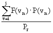 (5)
(5)Description
The Comprehensive Ocean-Atmosphere Data Set (COADS) is a global collection of instantaneous marine observations recorded between 1854 and 1993 that is available from the National Center for Atmospheric Research (NCAR) in Boulder, Colorado.
Until the 1930s, the majority of observations were reported to the nearest hour and degree. Observations recorded after that time were reported to the nearest hour and 0.1 degree.
Fields of interest to this study include: date, hour, position, data source, wind speed, and wind direction. Uncertainties for pertinent fields are listed in Table 1.1.
Acquisition and conversion
An electronic data file containing the portion of COADS bounded by 32E, 44E, 30N, 12N was obtained from NCAR. The data was received in two files: the Compressed Marine Reports (CMR) and the Long Marine Reports (LMRF). These two data sets differ in both time period and format. The earlier set (CMR) covers the period 1854-1969. Due to insufficient spatial resolution in early observations, this analysis will utilize CMR data beginning in 1933. The later set (LMR) covers the period from 1969 to 1993.
Each data file was downloaded in binary form and occupied approximately 20 MB of hard disk space. NCAR provided FORTRAN source code that, after alterations, converted the fields of interest from binary to ASCII. The resulting files enlarged through conversion from binary to ASCII, but reduced by omission of unnecessary observation fields -- were each approximately 25 MB and contained a combined total of over 650,000 observations.
Analysis
The resulting wind map can then be compared to other databases, including previous wind estimates in the northern Red Sea and satellite observations; however, it is not clear which data set should be considered most reliable. Assuming the ship and buoy data is accurate and comprehensive, it seems that the wind estimates based on these sources would be most accurate. However, since these observations are instantaneous, biases may be present if measurements for given locations do not have good temporal coverage. These factors will be considered and accounted for during analysis.
The tentative estimates presented in this report are based on the 1993 US Navy Climatic Study of the Red Sea and Adjacent Waters, which presents a variety of surface marine statistics. Wind speed and direction are presented as monthly averages in the form of wind roses covering one degree bins (about 100 square kilometers). Since the bins cover such a large area, clearly there will be individual sites within each bin that have higher (and lower) average wind speeds than is presented for the entire bin. Since we are looking for sites with particularly high average wind speeds, we can safely assume that a good wind site will have significantly better resources than what is calculated for the entire bin. That is to say, the calculations presented here are conservative.
Average Wind Speeds
Wind speeds less than or equal to 25 m/s were summed and counted for each position. Averages were calculated by adding the sum of wind speeds for each position to all four 0.1 degree boxes intersecting at that point. Latitude, longitude, wind speed sum and observation count for each bin having at least one observation was printed to a text file. The resulting CMR and LMR text files were then combined to provide a concise description of 0.1 degree resolution wind speed observations in the Red Sea between 1933 and 1991. Averages were calculated as the quotient of the wind speed sum and observation count for each bin. This procedure was repeated after dividing each dataset into two seasons: May through September, and October through April.
Annual and seasonal analyses
Direction
Seasonal wind direction frequencies have been calculated and plotted as wind roses for areas near the Eritrean coastline. This analysis differs from the Naval study by having higher spatial resolution (0.1 degree vs. 1.0 degree).
The results of this analysis are presented below.
The results presented here represent wind speeds at 10 meters height. It is expected that wind speeds at typical turbine hub heights of 30 meters or greater would be higher than those presented here. However, winds have been known to decrease with height, particularly in hilly areas. Therefore, we have chosen to present values at 10 meters without making any assumptions about the wind speeds at higher hub heights.
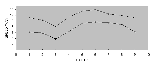
Table 5: Mean wind speeds at 10 m height at the two Aseb stations
|
|
|
||||||
|
Time
|
Summer |
|
|
Summer |
|
|
|
|
6:00
|
3.6
|
7.8
|
6.0
|
2.1
|
5.8
|
4.3
|
|
|
9:00
|
6.0
|
11.2
|
9.0
|
3.8
|
8.0
|
6.2
|
|
|
12:00
|
8.9
|
13.1
|
11.3
|
5.6
|
10.2
|
8.3
|
|
|
15:00
|
9.3
|
13.6
|
11.8
|
6.2
|
10.8
|
8.9
|
|
|
18:00
|
8.8
|
11.8
|
10.5
|
6.1
|
10.6
|
8.7
|
|
|
21:00
|
7.9
|
11.6
|
10.1
|
5.2
|
9.2
|
7.5
|
|
|
0:00
|
6.1
|
10.9
|
8.9
|
3.9
|
8.4
|
6.5
|
|
|
3:00
|
5.2
|
10.1
|
8.0
|
3.2
|
7.6
|
5.8
|
|
| Average |
7.0
|
11.3
|
9.5
|
4.5
|
8.8
|
7.0
|
|
Table 6 shows the parameters obtained using modified Weibull fits to the observed wind speed distributions as described in the Analysis under Calculation of Frequency Distributions. Again, values for 21:00, 0:00 and 3:00 are estimated as described above. Mean wind speeds presented in Table 6 are based on Equation 2.
Table 6: Modified Weibull parameters and resulting wind speeds at 10m height
|
|
|
||||||||
| Time |
k
|
A
|
s
|
MWS
|
k
|
A
|
s
|
MWS
|
|
| Summer | |||||||||
| 6:00 |
2.1
|
6.6
|
0.41
|
3.5
|
2.0
|
3.8
|
0.49
|
1.7
|
|
| 9:00 |
1.9
|
7.5
|
0.10
|
6.0
|
2.0
|
4.5
|
0.21
|
3.2
|
|
| 12:00 |
2.9
|
9.8
|
0.00
|
8.7
|
2.2
|
6.1
|
0.07
|
5.0
|
|
| 15:00 |
2.7
|
10.3
|
0.00
|
9.2
|
2.2
|
6.7
|
0.02
|
5.8
|
|
| 18:00 |
3.2
|
10.0
|
0.00
|
8.9
|
2.0
|
6.9
|
0.05
|
5.8
|
|
| 21:00 |
2.6
|
8.7
|
0.06
|
7.3
|
2.0
|
5.6
|
0.10
|
4.5
|
|
| 0:00 |
2.6
|
8.1
|
0.11
|
6.4
|
2.1
|
4.8
|
0.16
|
3.6
|
|
| 3:00 |
2.6
|
7.9
|
0.25
|
5.2
|
2.3
|
4.5
|
0.32
|
2.7
|
|
| Summer Avg. |
2.3
|
8.8
|
0.12
|
6.9
|
2.0
|
5.5
|
0.18
|
4.0
|
|
| Winter | |||||||||
| 6:00 |
2.4
|
10.0
|
0.10
|
8.0
|
2.0
|
7.6
|
0.12
|
5.9
|
|
| 9:00 |
3.2
|
12.8
|
0.02
|
11.2
|
2.5
|
10.0
|
0.06
|
8.3
|
|
| 12:00 |
3.3
|
14.7
|
0.00
|
13.2
|
2.6
|
12.4
|
0.03
|
10.7
|
|
| 15:00 |
3.5
|
15.3
|
0.00
|
13.7
|
3.0
|
12.9
|
0.01
|
11.4
|
|
| 18:00 |
3.8
|
13.4
|
0.01
|
12.0
|
3.4
|
12.6
|
0.02
|
11.1
|
|
| 21:00 |
3.2
|
13.3
|
0.00
|
12.0
|
3.2
|
11.1
|
0.03
|
9.6
|
|
| 0:00 |
3.2
|
12.1
|
0.02
|
10.6
|
4.1
|
9.7
|
0.06
|
8.2
|
|
| 3:00 |
3.2
|
12.1
|
0.02
|
10.6
|
3.2
|
9.6
|
0.05
|
8.2
|
|
| Winter Avg. |
3.4
|
13.2
|
0.02
|
11.4
|
2.4
|
10.3
|
0.05
|
8.7
|
|
| Annual Avg. |
2.4
|
11.5
|
0.06
|
9.6
|
1.8
|
8.9
|
0.10
|
7.1
|
|
Figure 5 is a graph depicting the mean diurnal wind speed variation. Higher wind speeds at midday increase power supplies during peak demand. Here it is clear that the wind speeds at the two stations are closely related.
| Annual |
6:00
|
9:00
|
12:00
|
15:00
|
18:00
|
21:00
|
0:00
|
3:00
|
Average | |
| Airport |
6.0
|
9.0
|
11.3
|
11.8
|
10.5
|
10.1
|
8.7
|
8.2
|
9.5
|
|
| Seaport |
4.3
|
6.2
|
8.3
|
8.9
|
8.7
|
7.5
|
6.3
|
5.8
|
7.0
|
Figure 6 shows mean annual wind speeds in the Red Sea along the southern Eritrean coastline. It can be seen here that the high wind speeds found at Aseb on the southernmost tip of the Eritrean coastline continue for at least one hundred and perhaps as far as two hundred kilometers up the coastline. We expect that many excellent high wind sites will be found in this area.
Mean Annual Wind Speed Frequency Distribution
Figures 7 and 8 show the modified Weibull fits to the average of the observed 3-hour wind speed distributions at the Aseb Airport and Seaport. In Figure 8, the "observed" distribution at the Airport is the average of the 5 actual distributions and 3 predicted distributions as described in the Analysis section under Calculation of Frequency Distributions.
Projected available wind power
The amount of potential electricity that can be generated depends on several factors, including the spacing between wind turbines, the assumed efficiency of the machines, the turbine hub height, and the estimated energy losses. The assumptions used for calculating the wind energy potential per unit of land area is given in Table 7. (Estimates of wind turbine efficiency and power losses are based on data from existing turbines. For advanced turbines, efficiency is projected to be 30%-35% and power losses 10%-15%).
Table 7. Assumptions: 30-m hub height, 10Dx5D spacing, 35% turbine efficiency and 25% power losses
|
|
|
|
|
|
|
|
|
|
|
|
|
|
|
|
|
|
|
|
|
?. Rotor diameter D: 20m
?. Average turbine spacing: 10D x 5D
Average annual wind speed (m/s) 7.2
Wind Power Density (W/sq. m) 511
Wind power available per turbine (kW) 167
Idi
Average annual wind speed (m/s) 7.6
Wind Power Density (W/sq. m) 677
Wind power available per turbine (kW) 221
NOTE: Height extrapolations based on 2/7 power law
Figure 8 shows wind roses for the summer and winter monsoons at Aseb. Once again, it can be seen that the winds at the two stations follow each other very closely. It is also noteworthy that during the winter monsoons, when winds are strongest, the wind blows predominantly from the southeast. This indicates that more efficient wind turbine spacing may be possible.
Before the discovery that there were two stations at Aseb (a fact not indicated in the data set), the annual average wind speed at Aseb appeared to be about 8 m/s. After dividing the data set accordingly, we encountered many problems in finding an accurate estimation of mean annual wind speeds at these two stations. Table 8 provides a summary of the Weibull parameters, mean annual wind speeds and wind power densities obtained using different methods of data analysis.
Table 8: Summary of the Results of Different Data Analysis Methods
|
|
|
|||||||
|
|
|
|
|
|
|
|
|
|
| Unadjusted |
10.3
|
7.3
|
||||||
| Linear Correlation |
9.5
|
920
|
7.0
|
480
|
||||
| Modified Fit |
2.4
|
11.6
|
9.6
|
915
|
1.8
|
8.9
|
7.1
|
538
|
| Standard Fit |
2.5
|
11.7
|
10.4
|
1025
|
1.8
|
9.3
|
8.3
|
688
|
Any resource assessment based on existing meteorological data is only suggestive and serves merely as an indicator of a promising resource. Such estimates cannot be used as the basis of economic calculations for utility-scale power generation without extensive, year-long site specific monitoring. For example, consider a site with an estimated annual average wind speed of 6 ± 1 m/s. This implies that the average annual wind speed might reasonably be anywhere between 5 and 7 m/s, which corresponds to a factor of 2.7 difference in power! An error this large can certainly make the difference between a wind site that is economical for energy production and one that is not.
Regional studies show only large areas of high wind resource potential. As a result, such large-scale studies can easily underestimate the wind resource potential of an area. For example, there may be a mountain pass within a relatively low potential area into which strong winds are regularly funneled. The preliminary study will not indicate such an area, even though it may be a very promising site. In this case, the ensuing research will not include this small, yet significant, resource, and it will doubtless be overlooked (Simon pers. com.).
In addition, existing mathematical models may be the cause of inaccuracy in some areas. This is especially likely in regions that experience large convective flows. In such situations, mathematical models do not account for the large vertical movements of air associated with convective wind flow. As a result, the model may carry a mass of air through a region when, in fact, this mass has traveled vertically up into the atmosphere and no longer has bearing on the wind flow at the surface. Likewise, a mass of air entering the boundary layer from above would produce quite different results at the surface than a mathematical model would predict.
Human estimates
Each data set from which this wind map will be constructed has inherent bias. These biases will reflect on the final output of the model. However, such biases will become less prominent as technologies improve and new data bases are created.
According to these results, the Eritrean coastline has an outstanding wind resource, particularly in the Aseb area. The data analysis presented here indicates that the mean annual wind speed at the airport is about 9.5 m/s while the mean annual wind speed at the seaport is about 7.5 m/s. We attribute this difference to the different levels of wind exposure at the two stations. The airport is located outside the city and has excellent wind exposure, whereas the seaport station is located in a developed area within the town.
There are several distinctive factors that might justify Eritrea taking a relatively advanced position with regards to wind energy development.
Eritrea's economic development is constrained by the lack of long-term investment capital. Due to current political concerns with regards to global carbon emissions, wind energy development would provide access to capital funds at subsidized rates (perhaps even as grants) that otherwise would not be available for electricity development. In addition, since energy supply is also one of the major constraints on national economic development, such additional investments will have an economic multiplier effect in addition to increasing the pace of national reconstruction.
The main constraint on wind energy development in the economically more advanced countries is the competition from natural gas generators [Grubb, 1993]. Because of the very high capital cost of transportation and distribution facilities for natural gas, such generators are not a feasible option for Eritrea in the next decade. Meanwhile, compared to electricity generation from diesel and fuel oil which costs $0.065 per kilowatt-hour, standard cost estimates indicate that for good wind sites, electricity generated from wind is cheaper than electricity generated from diesel.
Eritrea has already taken steps to perform a wind resources evaluation, a major constraint on wind energy development [Grubb, 1993]. The lack of wind resources evaluation expertise and technical capacity in wind electricity generation is probably one of the main factors limiting wind energy utilization in developing countries. Current technical capacity building activities are removing this constraint for Eritrea.
Eritrea has some unquestionably favorable wind resources. Unusually high wind speeds have been observed along the Southern coast. Other good sites have been found in highland passes in the center of the country. In addition, some of the physical properties of the wind resources at these sites increase its potential value. These include a highly periodic wind pattern with low variability [Yosief, 1996] at both sites, and a positive correlation between wind power availability and electricity demand in the highlands.
Due to these unusually favorable factors for Eritrean wind energy development, it may be to Eritrea's advantage to plan a relatively high level of wind power penetration for the energy sector. What remains is the technical question of the economic and physical feasibility of wind energy development in the Eritrean context.
Further funding for this project has been procured from the Global Environment Facility (GEF), a joint program between the United Nations Development Program (UNDP), United Nations Environment Program (UNEP) and the World Bank. A full scale wind prospecting effort will be undertaken under this grant. Results of the ensuing study are expected within a year.
Rough Cost Estimate for Aseb Project
Because of the uncertainties in wind speeds, cost estimates at this stage are highly unreliable. Using the estimated capacity factor of 58%, we can estimate wind power costs for two project scenarios: the first is a project with new turbines, a turbine lifetime of 20 years and maintenance and operational costs of $0.010 per kilowatt-hour:
Project #1: New Wind Turbines
Capital Costs $1200/kW
Maint. & Oper. $0.010/kWh
Interest Rate 3%
Project Lifetime 20 years
Cost of Electricity $0.025/kWh
Alternatively, we can consider the project costs using reconditioned wind turbines which cost approximately 1/3 the price of new turbines. We can presume that the project life would be shorter (10 years) and maintenance costs may be higher ($0.015/kilowatt-hour).
Project #2: Reconditioned Wind Turbines
Capital Costs $ 400/kW
Maint. & Oper. $0.015/kWh
Interest Rate 3%
Project Lifetime 10 years
Cost of Electricity $0.017/kWh
Under this scenario, the cost of electricity is much lower. However, using reconditioned turbines may entail additional risks and jeopardize the attainment of loans.
In developing wind power for the electric grid, the primary considerations are economic. Currently, only the Southern coastal region of Eritrea is clearly feasible for wind energy development. These resources could readily provide supplemental electricity supplies for the city of Aseb contributing up to 10-30% (~2 MW) of the total demand depending on the detailed characteristics of the wind energy resource. Yet the main electricity load in Eritrea is currently in the central highlands region. Therefore, if a more extensive wind power development is desired, economically feasible generation sites need to be found closer to the load center in the Eritrean highlands, or transmission from the Southern coast to Mitsiwae needs to be considered.
The main factor constraining wind power development near Aseb is its the relatively low demand and small size of the existing grid. Grubb and Meyer (1993) reviewed studies of the potential wind energy penetration of utility grids. Those studies considered how much wind energy could be added before operating penalties of an intermittent source became larger than the benefits. Although the study results varied, typical simulation results were between 15 and 30%. With large grids and the incorporation of a diversity of out-of-phase intermittent sources, the estimated potential contributed was as high as 45% without reliance on storage. The combined capacity of the power system is approximately 17 MW. Taking the conservative end of the range, this suggests that the Aseb utility, without expansion, could accommodate no more than about 3 MW of wind, which could be supplied by 5 to 10 medium size turbines.
Another problem with the wind resource at Aseb is that the peak supply is in the winter, while the peak demand in the summer. One plan that would both further exploit the wind resource and level the seasonal loads is a cooperative effort with Ethiopia, in which winter wind power from Aseb is traded for summer hydropower from the Blue Nile region. This option may not be feasible due to international instabilities.
Another option for distributing excess supply may be to connect the power system at Aseb to the national grid in the central highlands. Although this option is preferable in many respects, construction of transmission lines along the 500 km route may be prohibitively expensive and power losses unacceptably high.
Based on the promising results obtained from this preliminary resource assessment, wind power appears to be a potentially beneficial future source of energy for Eritrea. In order to realize this potential, the following work needs to be pursued:
Complete the physical resource assessment
For full exploitation of wind energy potential in Aseb, measures need to be taken to increase the reliability of the city power distribution system (VanBuskirk 1998). Research continues to be conducted in the Eritrean highlands, but further investigation into power transmission from Aseb to the highland area may be warranted.
2. Collection of cost and demand information regarding current electricity generation and fuel use.
3. Preliminary Project Design
4. Formulation of Project Evaluation Criteria.
5. Development of Project Financing Options
6. Formulation of Project Organization Chart and Operational Procedures
7. Hiring and Training of Project staff
8. Finalization of Project Design
The final decision on pilot project implementation necessarily will have to wait until the site assessments are complete. But as site evaluation awaits the year of data collection, pilot project formulation will proceed simultaneously. The formulation and implementation of a pilot utility scale electricity generation project will require a minimum of a US$ 100,000 investment (and more likely a US $300,000 investment).
Economic assessment of wind power
Additional research may be useful for informing policy makers and for developing an optimal technical and institutional infrastructure to support wind energy development in Eritrea. In order to assure the sustainability of wind energy development, a study of the organizational structure required to support utility-scale wind capacity, including an analysis of training and staffing requirements needs to be determined. Also an analysis of the experience of current wind energy development in China and India, will be useful to wind project planners and staff. Furthermore, an analysis of the operations and maintenance history of medium-sized utility-scale wind machines will help facilitate low-risk investments in Eritrean wind power.
If these steps are actively pursued, Eritrea will soon be in a good position to take advantage of its indigenous wind energy resources in an effective manner.
In this thesis, we attempted to advance the understanding of Eritreas wind energy resources in order to assist development in that country. We first defined the problem at hand, and then proceeded to provide detailed background information on the history, benefits, challenges, economics, and technology of wind energy. We then continued with the evaluation of Eritreas resource in particular. To evaluate Eritreas resource we presented a review of available data, discuss the methods we applied to analyzing that data, and present our results. We concluded with a discussion of the implication of these results for Eritrean wind energy development and presented a series of recommendations with regards to the next steps to take in Eritreas wind energy development program.
Wind energy is a fast-growing energy supply having reached a world-wide installed capacity of 5 GW by 1995. In Germany, today's largest wind energy market, installed wind power is increasing at a rate of 25% per year. If Eritrea is to take advantage of this fast-growing energy source, it needs to evaluate the wind energy resources available to it and engage in the planning necessary for wind energy development project funding and implementation. This report is a first step in developing Eritrea's wind energy resources.
Eritrea as a relatively poor country which is just beginning its reconstruction process. Because of its depleted biomass resources and a low level of electrification, there is a national need for rapid expansion of both the electricity supply and of energy supply in general. In order to satisfy these needs and the large latent demand for electricity and energy, Eritrea needs to invest in a diversified portfolio of cost-effective energy developments. Our preliminary results suggest that wind energy can make an important contribution to a diversified Eritrean energy supply.
Wind energy has a number of advantages and drawbacks. Primary advantages of wind energy development include both its lower cost when compared to diesel-generated electricity and its lack of carbon emissions (which may allow Eritrea to obtain loan subsidies from industrialized countries). Further advantages include its rapid installation, modular configuration, and utilization of national rather than imported energy resources. Disadvantages include the intermittence of the supply, the unfamiliarity of the technology in Eritrea, and a potentially limited scale of resource development.
Another issue of concern is what type of wind technology should be implemented in the Eritrean context. The current tendency in Europe is the development of very large, technically complicated wind machines with a generating capacity of 500 kilowatt or more. Such machines, because of their more complicated components and large size, will incur higher component replacement and installation costs. Another concern for the larger machines is whether or not current transportation and construction infrastructure in Eritrea can handle the installation in mountainous terrain in a safe and cost-effective manner. Consideration of these issues may lead to the use of smaller wind turbines for initial wind energy developments.
In order to convert the idea of wind energy development from concept to reality, Eritrea needs to engage in a variety of evaluation and planning activities. These include:
Currently, the Eritrean wind resource appears very promising, more than justifying continued study. Potential applications of wind energy development in Eritrea include not only utility-scale generation, but also electricity supply for small-scale isolated development projects, and fuel substitution for household cooking. The fact that the base supply of electricity in Eritrea will be produced by diesel generators during the next decade also increases the competitiveness of wind generation for electricity production. Another specific factor favorable to wind development in Eritrea includes the positive correlation between hourly wind speeds and hourly electricity demand. Electricity produced during periods of peak demand have added value due to the contribution they make to peak generating capacity and electric supply reliability during periods of greatest need.
To date, two regions of potential wind energy development have been identified: (1) the Southeastern coastal zone, and (2) Highland passes. The feasibility of the Southeastern coast for wind energy development seems clear at this stage. Marginal winds found in the central highland passes may be sufficient for economically viable wind development due to their proximity to an area with great demand for electricity.
The results of this preliminary assessment provide justification for continuing more detailed work on the identification of sites for wind energy development projects. Detailed monitoring of potential sites has begun with results expected in a year. It is now important to develop the policy criteria with which wind energy projects are to be evaluated. A defined policy combined with background information to be collected on costs and technical specifications of wind energy equipment will lay the foundation for quick and efficient evaluation and implementation of wind energy pilot projects. If such pilot projects prove to be a success, then Eritrea may find that a larger-scale of wind energy development is in the nation's best interest. It is then possible that future large scale wind energy developments will make an important contribution to the reduced cost, quantitative expansion, and increased reliability of Eritrea's electricity production. Such improvements in Eritrea's electricity supply, if attainable, will benefit the national economy, the post-liberation reconstruction process and the Eritrean people.
Ideally, a comprehensive wind study would generate an accurate wind map of the entire country of Eritrea, to be used as a tool for policy makers to select sites for wind energy development and to attract wind energy investments. Such maps have been generated for the US, Europe, and many other regions of the world. Since a comprehensive set of wind data records was not available for Eritrea, the scope of this study was narrowed to encompass a search for and evaluation of all existing wind data with the goal of identifying promising wind energy sites.
Aspliden, C., Elliott, D., Wendell, L. (1986) "Resource Assessment Methods, Siting, and Performance Evaluation" In: Physical Climatology for Solar and Wind Energy. Singapore: World Scientific, pp. 321-376.
Barros, V. (1986) "On the Extension of Wind Series from Short Records." In: Physical Climatology for Solar and Wind Energy. Singapore: World Scientific, pp. 874-892.
Brower, M., Tennis, M., Denzler, E., Kaplan, M. (1993) Powering the Midwest: Renewable
Electricity for the Economy and the Environment. A report by the Union of Concerned Scientists.
Elliott, D., Cherry, N., Aspliden, C. (1981) "World-Wide Wind Energy Resource Assessment"
In: Energy and Special Applications Programme Report No. 2 (1981), Secretariat of World Meteorological Organization, Geneva Switzerland.
Festa, R., Ratto, C. (1986) "Mapping the Climate" In: Physical Climatology for Solar and Wind Energy. Singapore: World Scientific, pp. 987-1057.
Gipe, P. (1991) "Wind Energy Comes of Age." Energy Policy, v. 19, pp. 756-767.
Golob, R., Brus, E. (1993) The Almanac of Renewable Energy. New York: Henry Holt.
Grubb, M., Meyer, N. (1993) "Wind Energy: Resources, Systems and Regional Strategies." In: Renewable Energy: Source for Fuels and Electricity. Washington DC: Island Press, pp. 157-212.
Habtesion, S. (1994) "Energy Development and Environmental Sustainability." Eritrean National Environmental Management Plan, pp. 7-12
Halliday, J., Gardner, P., Bossanyi, E. (1986) "Wind Monitoring for Large Scale Power Generation on Shetland." In: Energy for Rural and Island Communities IV. Oxford: Pergamon Press, pp. 185-192.
Jagadeesh, A. (1987) "Wind Energy Potential in Coastal Areas in India" Alternative Energy Sources VII, vol. 3, pp. 69-73.
Landberg, L., Mortensen, N., Petersen, E. (1995) "Wind Resource Assessment and Siting A Wider Perspective" In: European Directory of Renewable Energy Suppliers and Services. London: James & James, pp.170-176.
Landsberg, H. (1972) "Climates of Africa" In: World Survey of Climatology, v. 10.
Mikhail, A., Justus, C. (1986) "Comparison of Height Extrapolation Models and Sensitivity Analysis" In: Physical Climatology for Solar and Wind Energy. Singapore: World Scientific, pp. 377-397.
Miller, A., Simon, R. (1978) Wind Power Potential In California. A report by the Department of Meteorology, San Jose State University, CA for the California Energy Commission.
Minnesota Department of Public Service (1994) Minnesota Wind Resource Assessment Program.
A report by the Minnesota Department of Public Service.
Niang, C. (1990) "From Ecological Crises in the West to the Energy Problem in Africa." International Social Science Journal, v. 124, pp. 225-239.
Petersen, E., Mortensen, N., Landberg, L. (1994) "Wind Resource Estimation and Siting of Wind Turbines." In: European Directory of Renewable Energy Suppliers and Services. London: James & James.
Petersen, E., Troen, I. (1986) "Rational Methods of Wind Energy Siting" In: Reviews of Renewable Energy Resources. New York: Halsted Press.
Radwan, A. (1987) "Wind Energy in Saudi Arabia." In: Alternative Energy Sources VII, vol. 3.
Rahmatullah, M., Khan, J., Farooqi, S. (1987) "Wind Potential in Northern Parts of Pakistan."
In: Alternative Energy Sources VII, vol. 3, pp. 45-48.
Ramsdell, J., Houston, S., Wegley, H. (1980) "Measurement Strategies for Estimation Long-Term Average Wind Speeds," PNL-3448, Pacific Northwest Laboratory, Richland, Washington.
Shitao, L., McCarty, J., Nelson, V. (1994) Wind Resource Screening in the Texas Panhandle.
AEI Report 94-1, West Texas A&M University.
Troen, I., Petersen, E. (1989). European Wind Atlas. Riso National Laboratory, Toskilde, Denmark.
Wentz, F. (1992). "Measurement of Oceanic Wind Vector Using Satellite Microwave Radiometers." IEEE Transactions on Geoscience and Remote Sensing, Vol. 30, No. 5, pp. 960-972.
Meteorological data for less developed areas may be extracted from global datasets, but are generally incomplete as well as lacking sufficient spatial and temporal resolution. More complete datasets can often be found within the country or region of interest. Meteorological and climatological stations as well as airports are likely to have reliable information. Although many of these are included in the global databases, some may be not be. The World Meteorological Organization maintains a record of all land-based stations worldwide at which meteorological observations are made.
Eritrean Department of Water Resources Data
Source: Hydrometeorological Services Unit of the Water Resources Department
of the Ministry of Mines, Energy, and Water Resources
Sensor: Weather stations
Coverage
Spatial: Asmara, Shambuko, Fil-Fil, Sheeb, Om Hajer, and Tzerona
Temporal: April 1994 to present 15 minute averages
Wind Data: Wind speed
Wind direction
Height: 3m
Other data: Temperature, Solar radiation, Relative humidity
Form: Diskette
Cost: Free
Air Weather Service Hourly Data
Source: National Oceanography and Atmospheric Association, NCDC
US Air Force DATSAV2 Surface Observations (TD9950)
Air Weather Service Global Climatology Division, Federal Climate Complex
Sensor: Weather stations
Coverage
Spatial: Global
Temporal: May 1973 to March 1996 1 hour averages
Wind Data: Wind speed, Wind direction
Height: 10m
Other data: Temperature Max temperature
Dew Point Min Temperature
Sea level pressure Precipitation
Station pressure Snow depth
Visibility fog, rain, snow, hail, thunder, or tornado
Form: ASCII
Cost: $20 per year per station (discount for whole countries)
Global Surface Summary of Day Data
Source: National Oceanography and Atmospheric Association, NCDC
US Air Force DATSAV2 Surface Observations (TD9950)
Air Weather Service Global Climatology Division, Federal Climate Complex
Sensor: Weather stations
Coverage
Spatial: Global
Temporal: March 1994 to March 1996 1 day averages
Wind Data: Wind Speed, Max. sustained speed, Max. wind gust
Height: 10m
Other data: Temperature Max temperature
Dew Point Min Temperature
Sea level pressure Precipitation
Station pressure Snow depth
Visibility fog, rain, snow, hail, thunder, or tornado
Form: ASCII
Cost: Free
Source: NASA Jet Propulsion Laboratory PODAAC
The original ERS-1 data files are unavailable to the public
Sensor: ERS-1 AMI scatterometer
Coverage
Spatial: Global 25 x 25 km
Temporal: January 1992 to the present
Wind data: Wind speed, Wind direction
Media: 8mm tapes
Form: UNIX Tar
Size: One month is approximately 350 MB
Cost: Free
SSM/I Wentz Geophysical Products
Source: NASA Jet Propulsion Laboratory PODAAC
Sensor: SSM/I (Special Sensor Microwave Imager) instrument on the DMSP F-8 and F-10
Temporal: July 1987 to December 1992 14.1 revolutions per day
Wind data: Wind Speed
Height: 19.5m
Medium: 8mm tapes
Form: HDF
Size: One month is approximately 1 GB
Cost: Free
The NASA/Goddard Earth Observing System (GEOS) Data Assimilation System (DAS)
Source: NASA/Goddard Space Flight Center
Sensor: Global data assimilation system which utilizes ship and buoy sea level pressure and
Temporal: 1 Mar 85 -> 1 Oct 93 Monthly averages
Wind data: Wind Speed, Wind Direction
Height: 2m and 10m winds available
Medium: Downloadable
Form: ASCII; GrADS
Size: One month is approximately 5 MB
Cost: Free
Navy Regional Climatic Study of the Red Sea and Adjacent Waters
Source: Naval Oceanography Command Detachment, Asheville, N.C.
Sensor: Ships, buoys
Coverage
Spatial: Red Sea area 1 x 1 degree
Temporal: One year (based on 40 years data) Monthly averages
Wind data: Wind Speed, Wind Direction
Height: 10m
Medium: Bound Report, 252 pgs.
Form: Wind roses and isopleths
Cost: $40
C. Graphical Data
To track cloud movement, real-time photographs taken from satellites may be viewed and downloaded from the Internet. Although these photographs are not directly useful as wind data, they are useful qualitative indicators of regional air-flows.
Source: United States Geological Survey
Medium: 8mm tape
Form: 16-bit straight raster image files in a latitude/longitude coordinate system
Size: 200 MB (can be obtained as four separate 50 MB blocks)
Cost: Free
African Data Sampler
Source: World Resources Institute, Washington D.C.
Data: Topography, Vegetation, Lakes and rivers,
Form: PC ArcView format
Size: about 2 MB per country
Cost: $50
APPENDIX B: CONCURRENT WIND PROSPECTING EFFORTS
Ground survey efforts have been concentrated in areas within forty kilometers of the capital, Asmara, where the central electricity grid is located, but more distant locations will also be examined. The lower transmission costs of sites near the central grid make such sites more desirable at the early stages of development and warrant more intensive prospecting efforts. The larger volume of lower-reliability indicators and data is assisting the identification of a range of potentially promising sites for future study.
The ground surveys for promising wind sites have indicated that most locations in the Eritrean highlands have moderate winds (~3 m/s at 10 m height). But a few locations have been found that show promise for significant wind resources. These locations tend to be near passes or areas through which cooler Red Sea air passes as it flows to the West during the dry season. During the wet season, winds appear to be moderate at almost all locations. The results from the more promising wind sites are described in Appendix B.
To date only one series of follow-up spot measurements have been made at Dekemhare during the low-wind rainy season. The details of these measurements are described in Appendix B. A more intensive program of such measurements is planned for the coming months.
Preliminary identification of some potential wind energy sites in the central highlands region has been made, based primarily on a few spot measurements and biological indicators. The most promising site so far is the mountain pass at Dekemhare at which spot measurements during the dry season indicate wind speeds of 8 m/s to 15 m/s (at 2.5 m. height) during the day. If the daily wind pattern for this location is similar to that of other highland areas, then this implies a mean wind speed in the range of 5 m/s to 9.5 m/s during the dry months. Spot measurements during the rainy season indicate a distinct decrease in wind speeds during June to September (similar to the decrease in winds at Aseb during this time), with mean wind speeds of only 3 m/s to 5 m/s during the rainy season. Therefore, preliminary indications from these spot measurements are that overall mean speed at 10 m. height for the better highland spots is likely to be in the range 5 m/s to 10 m/s. Feasible wind generation sites have mean wind speeds in excess of 6 m/s at 10 meters height. Hence it is likely--but not certain--that feasible wind generation sites exist in the highland passes near the main electricity load in Eritrea. Other sites that show promise based on cursory evaluation and biological indicators include Maereba, Nefasit, and hills near Adi Teklezan.
The work is analogous to the highly successful early assessment of the Altamont Pass site [Simon, 1984; Davis and Nierenberg, 1980] and gives us confidence that windy locations can be found using a thermal meteorological analysis despite the limited number of meteorological stations.
A preliminary correlation analysis of wind data collected by the Eritrean Department of Water Resources has been performed by Robel Yosief, a senior physics student of the University of Asmara. In brief, this analysis shows that a month-long series of two-hour wind speed averages is well approximated by a periodic signal with a period of one day. The correlation between a periodic signal and two-hour average data for one month periods is 0.7 on average. This indicates that errors of only 15-30% are obtained when approximating wind data by a periodic function.
Furthermore, Robel Yosiefs study indicated a low place-to-place correlation of daily average wind speeds (less than 0.3) lending support to the idea that Eritrean winds are produced by thermal forcing effects interacting with local topography, and are not produced from synoptic scale weather systems. Further work will include an analysis of seasonal wind correlations, which hopefully will shed light on seasonal and annual variations in wind speeds.
Examination of Satellite Images
Satellite images are an important meteorological analysis tool. Visible and infrared Meteosat and NOAA images have been examined to obtain qualitative indications of wind patterns and meteorological mechanisms.
Examination of Satellite images has helped confirm the identification of Dekemhare as an important Eritrean wind site. Images reveal the air motions through the Dekemhare pass by virtue of the observed cloud formations (a fog bank Northeast of Dekemhare and lee wave clouds to the West). Relative to other locations, the flows through Dekemhare appear to be some of the most significant through the highlands. Satellite images also provide evidence for other potential sites including mountain passes near Adi-Keyh, Debresina, Ghizghiza, and Hishkib (near Nacfa). But such indications of mountain pass wind sites will have to be confirmed through site visits which have yet to be made.
APPENDIX C: PRELIMINARY SPOT MEASUREMENT RESULTS
Also for the spot measurement results, I will have to produce for you a report on the more recent data from Eritrea, so that Appendix B can be updated. Dont forget to nag me if I lag on that job. - Robert
During the past six months a moderate intensity effort to make ground measurements of wind speeds at a wide range of locations is being pursued. At the initial stages the only available measuring device has been a pivoted flap anemometer. And later two used cup anemometers were acquired. The cup anemometers produce an AC output voltage that is proportional to the wind speed. These anemometers were calibrated relative to a newly acquired anemometer that was installed with a meteorological data logging station at the Energy Center in Asmara. No adjustments were made for altitude. Calibrations were performed at 2300 m.
Approximately 15 locations in the highlands have been examined with spot measurements with most sites being visited only once. Most sites have only moderate wind speeds. But several sites showed promising signs of either high winds speeds, biological indicators of high winds or both. These sites include: the pass at Dekemhare, the valley near Maereba, hills near Adi Teklezan, and the pass at Nefasit. Dekemhare, Maereba, and Nefasit have trees with flagging and have been observed to have winds of approximately 10 m/s in the afternoon during the dry season. The hills near Adi Teklezan have trees with flagging. Below we discuss the results of measurements near Dekemhare in more detail.
In February a series of measurements were made with the flap anemometer at locations between 30 and 50 km south of Asmara. These measurements indicated afternoon wind speeds of 10 m/s or above in two areas: near Dekemhare and near Maereba. Both locations had abandoned windmills for water pumping that were installed during Italian colonial times in the 1930's. The measurements were not adjusted for altitude.
On 17 March 1996, a series of follow-up measurements were made in the Dekemhare area which indicated wind speeds of 8 m/s to 15 m/s from 11 a.m. to 4 p.m. in the afternoon.
Site #1 Site #2
Time Wind Speed Time Wind Speed
(hr:min) (m/s, 5 min mean) (hr:min) (m/s)
11:05 9.8 12:03 10.1
11:18 8.8 12:33 11.9
13:08 8.7 16:15 11.7
15:38 10.3 16:25 14.7
16:57 10.3
These measurements were taken at 2.5 m height with a flap anemometer. Both sites are on top of a hill or ridge. Winds were from the North. Adjustments were made for measurement bias from the anemometer, but no adjustments were made for altitude (such adjustments would increase the wind speed estimates).
Of course such measurements should be interpreted with caution, but the high wind speeds were supported by nearby biological indicators which included eucalyptus trees with complete flagging (no medium-sized branches on the upwind side of the tree). Furthermore, statistical analysis of temporal wind speed variations (Yosief, 1996) indicate that wind speeds in Eritrea have a highly periodic daily cycle. For Asmara, the nearest station with detailed data, the root mean square difference between a periodic wind signal and two-hour average wind data is 40% of the mean wind speed and less than 25% of the average daily peak wind speed. Therefore our estimate of the daily peak wind speed for site #2 is 12 m/s, with an error of this estimate of approximately 25% (4 m/s). For Asmara, the meteorological station closest to Dekemhare, mean peak daily wind speeds are approximately 1.7 times the average wind speed. If we assume that the same holds true for site #2 near Dekemhare, then our measurements indicate a mean wind speed of approximately 5 m/s to 9.5 m/s during the dry season. Note that along the Southern coast during the dry season, mean wind speeds are in the range of 7 to 9 m/s.
Another series of spot measurements were taken for site #2 near Dekemhare on 4 June, 1996. This was a rainy day in the highlands, and the meteorological conditions were those of the rainy season with winds from the South. The data were taken with a calibrated cup anemometer at 3.5 m height. This series of measurements yielded the following:
Site #2
Date: 04 June 1996 Date: 05 June 1996
Time Wind Speed (m/s) Time Wind Speed (m/s)
15:00-16:00 5.2 07:00-08:00 2.7
16:00-17:00 6.2 08:00-09:00 5.1
17:00-18:00 6.1
18:00-19:00 5.6
19:00-20:00 5.6
22:00-23:00 3.8
It should be noted that the wind was observed to be quite calm before 7:24 am on 05 June, and at this time the wind speed abruptly picked up. If one takes this data, plots it over a 24 hour cycle, and uses linear interpolation (fixing the speed at about 0.5 m/s at 7:20 am) one obtains an average wind speed of approximately 4 m/s. This indicates that the mean wind speed during this time is between approximately 3 m/s and 5 m/s during this period, or slightly higher than Asmara. Comparison of this data with observations at 12 m height in Asmara at the same time indicated that the observed wind speeds were 15-30% higher than speeds at 12 m height in Asmara.
The decrease in wind speed during the highland rainy season is mirrored by the decrease in wind speeds along the Southern coast where mean winds are approximately 3-4 m/s at this time.
Overall, these data indicate a promising potential at the Dekemhare location with an estimated annual mean wind speed of approximately 6.5 m/s at approximately 3 meters height. We expect winds farther above the ground to be significantly stronger indicating a potentially excellent wind site. But the errors in these measurements are large and many more measurements need to be taken before conclusions about site potential can be made.