(1)Department of Energy, P.O. Box 5285,
Asmera, Eritrea, robert@punchdown.org
(2)Department of Environmental Studies,
San Jose
State University, San Jose, CA 95192-0116, U.S.A.
This paper describes the collection and analysis of historical surface
wind data for the southern Eritrean coastline. Results indicate areas of
outstanding potential for utility-scale wind development. Winds along the
coast are directed by summer and winter monsoons in addition to diurnal
land-sea effects. Mean annual wind speeds range from 6 to 8 meters per
second for the southern half of the Eritrean coastline. Data recorded at
the Aseb airport between 1977 and 1986 indicate a mean annual wind speed
of 10 m/s and a mean annual wind power density of just under 1 kW/m2.
Introduction
Mulugetta and Drake (1996) conducted a study of wind potential for Ethiopia, Djibouti, and Eritrea.1 Their results indicate that the highest potential for wind development is along the Eritrean coastline. Other studies of the region surrounding the Red Sea and Gulf of Aden have also issued promising results (Elliott & Renne, 1987) (Pallabazzer, & Gabow, 1991)(Radwan, 1987). This study provides a more detailed account of the wind potential in Eritrea and discusses the feasibility of wind power integration at the southern Eritrean port city of Aseb..
Background
Eritrea
The capture of the capital city of Asmera in 1991 ended the Eritrean struggle for independence from Ethiopia. As a result of over three decades of war, famine, and poverty, Eritreas resources are now seriously depleted. The country suffers an energy shortage that severely limits its economic productivity. Over 80% of the population have no electricity and biomass resources are so scarce that many have scarce fuel even for basic cooking needs. Eighty percent of primary energy demand is met by biomass in this semi-arid region that is already largely deforested.
This young nation, validated by UN-supervised referendum in 1993, has shown admirable foresight by committing itself to a development path that promotes environmental protection and rehabilitation, while maximizing fiscal and political independence and security. These goals cannot be met by the usual model of development based on imported fossil fuels. A 1995 newsletter prepared by the Secretariat of the National Environmental Management Plan for Eritrea (NEMP-E) describes the energy crisis in Eritrea and the development policy of the Eritrean government.
Study Area
Eritrea occupies the southernmost 1200 km of the Red Sea shoreline, including hundreds of islands near the major ports of Mitsiwa'e in central Eritrea and Aseb in the south.
Topography
Eritrea occupies the southernmost 1200 km of the Red Sea shoreline, including hundreds of islands near the major ports of Mitsiwa'e in central Eritrea and Aseb in the south.
The capital of Asmera is located in central Eritrea on a plateau at over 2000 meters elevation. This high plateau and the surrounding hillsides are known as the central highlands. To the east and west are the western and coastal lowlands respectively. The western lowlands consist chiefly of desert hills and savanna. To the east, the high plateau drops abruptly to the wide, arid coastal plain, which stretches the entire length of Eritrea. South of Mitsiwa'e, the coastal plain dips to 100 meters below sea level at the Danakil depression, which divides the central highlands in the west from a much smaller range of mountains in the east. This second range parallels the shoreline from the Danakil depression to beyond the Djibouti border, reaching less than 2000 meters at its highest point.
Demographics and the National Electric Grid
The population of Eritrea is estimated at 2.7 million. Of that number, roughly 20% inhabit Asmera and the high plateau. Although accurate population counts for other major cities are not available, it is estimated that more than half of the Eritrean populace lives in the towns and cities of the highlands. The main national electric grid stretches from Mitsiwa'e to Asmera, and then continues south to Adi Quala. A second, smaller, national grid is located at Aseb.
Meteorology
Wind patterns in this region are controlled to a large extent by two distinct monsoons that are separated by 30 to 45 days each. The Northeast Monsoon dominates the southern half of the Red Sea from November to March. The African equatorial low centered at 10N 30E creates a strong southeast wind that is pulled through the narrow Bab el Mandeb at the southern mouth of the Red Sea. This wind slows as it continues toward Mitsiwae where it converges with the northwest wind. Much of the resulting air mass is drawn southwestward across the Eritrean highlands toward the African equatorial low pressure system centered in southern Sudan. During the Southwest Monsoon from May to September, the warm Pakistani low formed at 30N 65E causes surface winds along the entire length of the Red Sea to blow from the northwest, down the length of the Red Sea, and out into the Gulf of Aden (Navy).
April and October comprise most of the two transition periods. For this study, however, the transition months are grouped with the winter monsoon months based on similar mean wind speeds.
[Figure: Average monthly wind speeds at station 2)
Data Search and Study Overview
Our original goal was to use existing data to locate potential sites for utility-scale wind power development in Eritrea. We began our study by searching for existing sources of wind information. In the course of this search we discovered that most of the wind data that had been collected was lost at the end of the Eritrean war of independence in 1991. The three sources of wind information that were found in our initial search are described below..
Continuous 15 minute averages recorded at 7 stations in the highlands and western lowlands by the Eritrean Department of Water Resources
Station Geographical Coordinates MAWS (m/s)
Asmera 15º 17´ N 38º 55´ E 2 - 3
Filfil 15º 36´ N 38º 57´ E 1 - 2
Kerkebet 16º 18´ N 37º 24´ E 2 - 4
Omhajer 14º 20´ N 36º 39´ E 1 - 2
Shambiko 14º 57´ N 37º 53´ E 1 - 2
Sheb 15º 51´ N 39º 03´ E 1 - 2
Tsorena 14º 39´ N 39º 13´ E 1 - 2
Intermittent daily averages recorded at 4 stations along the Italian-built railroad line from Mitsiwae to Keren during the Italian occupation
Station Geographical Coordinates MAWS (m/s)
Asmera 15º 17´ N 38º 55´ E 2.7
Faghena 15º 10´ N 39º 28´ E 2.1
Keren 15º 46´ N 38º 27´ E 1.9
Mitsiwae 15º 37´ N 39º 27´ E 3.7
These preliminary estimates indicate that wind speeds at the existing meteorological stations in the Eritrean highlands are not adequate for utility wind generation. However, since these stations were not originally erected for wind prospecting purposes, and since the highland area is riddled with hills and valleys that could significantly enhance wind speeds, it is expected that a further investigation will reveal sites in this area with better wind potential (VanBuskirk, 1997). The Naval report for the Red Sea, however, indicates higher wind speeds along the southern coastal region of Eritrea. For this reason, we decided to pursue a detailed study of this area.
[Map of Stations]
Coastal Study
Data
U.S. Navy Regional Climatic Study of the Red Sea and Adjacent Waters (1993) and its predecessor Climatic Study of the Red Sea South and Gulf of Aden (1982) were both derived from the Comprehensive Ocean-Atmosphere Data Set (COADS). COADS is a global collection of instantaneous marine observations recorded on ships between 1854 and 1993. Original observations were recorded to the nearest knott, with 0.1 degree spatial resolution.
The portion of COADS from 12N to 30N, and from 32E to 44E was obtained from the National Center for Atmospheric Research (NCAR). The data is distributed in two electronic files: the Compressed Marine Reports (CMR) and the Long Marine Reports (LMRF). The earlier set (CMR) covers the period 1854-1969. Until the 1930s, the majority of observations were reported to only the nearest degree. To preserve a spatial resolution of 0.1 degree, this analysis utilizes only the CMR data recorded after 1940. The later set (LMRF) covers the period from 1969 to 1993 and is recorded entirely with 0.1 degree resolution. After checking the data for missing value indicators and other inconsistencies, the combined data sets contained over 500,000 useable observations.
Analysis
To remove biases that would result from uneven temporal sampling in the data, the data was divided into four 6-hour periods for the two monsoon seasons, producing a total of 8 temporal bins. For each temporal bin, a map was produced by utilizing a Gaussian-weighted averaging of the data. Consequently, an average wind speed map was calculated for four periods of the day for both the summer monsoon and winter monsoon seasons. The four periods were then averaged for each season, and the annual average was calculated as the sum of 5/12 of the summer monsoon season average and 7/12 of the Northeast Monsoon season average.
The results of this analysis are shown in Figure 2 which is a map of mean annual wind speeds in the Southern Red Sea. The results show annual mean wind speeds along the lower 200 km of the Eritrean coastline of between 6.5 and 8 meters per second. The high average wind speed just inside the Bab el Mandeb indicates an especially strong potential for continuing strong winds along the shoreline in the area of Aseb.
The general wind speed pattern shown here can be understood by thinking of the Bab el Mandeb as a narrow conduit for a layer of marine air which flows from the Gulf of Aden to the Red Sea during the Northeast Monsoon season. The highest wind speeds are at the point of maximum constriction of the conduit, while the lowest wind speeds are at the convergence zone at the widest point in the conduit. As noted in previous work (cite Italy paper), indications of this low-level jet can be seen in cloud patterns and satellite images.
Aseb Study
Background
Aseb
Aseb is a port city of about 50,000 people located at the southernmost tip of the Eritrean coastline. This area is extremely hot and dry. Summer temperatures from June to September average 40-50ºC and rain is rare. The economy here relies on the port, which is shared with landlocked Ethiopia. Other industries include the salt production, the national petroleum refinery, and a small fishing industry.
Energy situation
City, Port, Refinery
The capacity of the Aseb power system is approximately 17 MW, though this may soon decrease to 11 MW due to the shut-down of selected operations at the refinery. The average total demand is 5.3 MW, fluctuating from a low of 4.0 MW during the cooler winter monsoon season to a high of 8.1 MW in the hot summer monsoon season.
Data
Until the end of Ethiopian occupation in 1991, weather observations at Aseb were reported to the United States Air Force Environmental Technical Application Center (USAFTEC) and archived in the DATSAV2 Surface Climatic Database. (Now, observations are taken but not reported). Thirteen full years of DATSAV2 data were obtained for Aseb from the National Climatic Data Center (NCDC) in Raleigh, North Carolina.
Although DATSAV2 data are described as hourly observations, almost all of the observations taken at Aseb were recorded every 3 hours beginning at midnight. Accordingly, the data was divided into 8 groups, each containing a three hour interval.
Estimated mean wind speeds for each year reveal that observation frequency and wind speeds are not consistent on a long term basis. Earlier years almost completely lack records of observations during the late evening and early morning hours. Regular midnight and 3 a.m. recordings do not appear until late in 1986. In addition, the data indicate a 2 to 3 m/s decrease in mean wind speeds after this point in time. We concluded that the data set contains observations taken at two separate locales. This hypothesis has since been confirmed by the Eritrean Civil Aviation Department.
The Civil Aviation Department maintains two stations in the Aseb area. One station is located at the airport while the other is near the seaport within the town of Aseb. The lower wind speeds recorded at the seaport station can be explained by the fact that it is at the shoreline and surrounded by buildings. In contrast, the airport station recording higher wind speeds stands in a flat area at about 10 meters elevation, surrounded by no vegetation and few buildings. After the data set was checked for further inconsistencies, over 5,000 observations remained for each station.
Mean Wind Speed and Power Density Estimates
Of the 16 data subsets eight 3-hour intervals at each station 3 contain insufficient data for analysis: those for 9 p.m., midnight and 3 a.m. at the airport. To estimate the mean wind speeds during these data gaps, the wind speed frequency distribution was calculated for the 13 intervals having a sufficient number of data. Mean wind speeds were derived as:
SUM(WS*F(v))
where WS is the wind speed and F(v) is the frequency of its occurrence. Using linear regression analysis, a correlation was derived between the 5 available pairs of mean wind speeds (R2 = 0.96) and wind power densities (R2 = 0.90) at the two stations. The three missing values were then calculated as A = mS + b, where A and S are the mean wind speeds at the Airport and Seaport respectively, and m and b are the slope and y-intercept found in the regression analysis. A similar method was used to calculate the mean wind speeds and power densities on a seasonal basis.
|
Airport (1977 1986)
|
Seaport (1987 - 1991)
|
|||||||||||||
|
n
|
MWS
|
WPD
|
n
|
MWS
|
WPD
|
|||||||||
| 06:00 |
534
|
6.3
|
408
|
530
|
4.3
|
172
|
||||||||
| 09:00 |
1838
|
9.3
|
880
|
1176
|
6.2
|
355
|
||||||||
| 12:00 |
1394
|
11.6
|
1355
|
619
|
8.3
|
703
|
||||||||
| 15:00 |
1531
|
12.1
|
1494
|
1097
|
8.9
|
760
|
||||||||
| 18:00 |
499
|
11.1
|
1130
|
662
|
8.7
|
722
|
||||||||
| 21:00 |
10
|
(10.4)
|
(975)
|
669
|
7.5
|
492
|
||||||||
| 24:00 |
0
|
(9.2)
|
(765)
|
83
|
6.5
|
357
|
||||||||
| 03:00 |
10
|
(8.3)
|
(649)
|
303
|
5.8
|
282
|
||||||||
| Annual |
9.8
|
957
|
7.0
|
480
|
||||||||||
| Southwest | Monsoon |
7.3
|
478
|
4.5
|
174
|
|||||||||
| Northeast | Monsoon |
11.5
|
1301
|
8.8
|
699
|
|||||||||
Wind Power Densities based on: sum(½ f(v)*v3*rho), where rho=1.16 (explain & cite)
Wind Speed Frequency Distribution Estimates
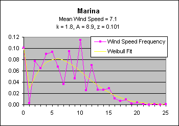
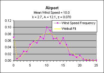
Capacity factor is defined as the ratio of actual energy output to the amount of energy a project would produce if it operated at full rated power for 24 hours per day within a given time period. Deriving a wind speed distribution for each of our 16 data subsets was prerequisite for estimating the potential capacity factors for our sites. To estimate the wind speed distributions for the three missing data subsets, a Weibull distribution is assumed as is standard (). In fitting the Weibull distribution to the Aseb data, however, a good fit could not be attained due to the high number of wind speeds recorded as zero.
Although other studies have passed off similar findings as recording errors (), we felt that the number of zero recordings, which in some intervals represent more than 40% of the observations, was too significant to dismiss. Since the Weibull distribution defines the probability of having a zero wind speed as zero, we feared that performing a standard Weibull fit to the data would produce a fictitiously high average wind speed.
To improve the fit, we assume that the recorded zeroes are correct. To the standard Weibull parameters of k and A we add a variable z denoting the frequency of wind speed observations recorded as zero. The Weibull distribution was then fit to the wind speed frequency distribution above 0 m/s and multiplied by 1-z.
This method improved the Weibull fit significantly (give RMS). The mean
wind speeds calculated as ![]() are
within 2% of the results of the linear correlation method described above.
The same method is used to fit the Weibull distribution to the full data
set for each station. The results of this fit can be seen in Figure 5.
are
within 2% of the results of the linear correlation method described above.
The same method is used to fit the Weibull distribution to the full data
set for each station. The results of this fit can be seen in Figure 5.
Results
Diurnal variation of mean wind speeds
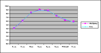
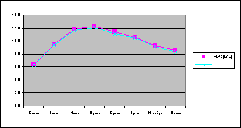
Data Weibull Data Weibull
6 a.m. 6.3 6.4 6 a.m. 4.3 4.2
9 a.m. 9.3 9.4 9 a.m. 6.2 6.2
Noon 11.6 11.8 Noon 8.3 8.3
3 p.m. 12.1 12.3 3 p.m. 8.9 9.1
6 p.m. 11.1 11.5 6 p.m. 8.7 8.9
9 p.m. 10.4 10.5 9 p.m. 7.5 7.5
Midnight 9.6 9.3 Midnight 6.5 6.3
3 a.m. 8.3 8.6 3 a.m. 5.8 5.9
Projected available power
The amount of potential electricity that can be generated is dependent on several factors, including the spacing between wind turbines, the assumed efficiency of the machines, the turbine hub height, and the estimated energy losses (caused by wind turbine wakes, blade soiling, etc.). The assumptions used for calculating the wind energy potential per unit of windy land area is given in Table 2.(Estimates of wind turbine efficiency and power losses are based on data from existing turbines. For advanced turbines, efficiency is projected to be 30%-35% and power losses 10%-15%).
Table 2. Assumptions: 50-m hub height, 10 D x 5 D spacing, 25% efficiency, and 25% power losses
|
|
|
|
|
|
| 4 | 450 | 7.07 | 1.33 | 11.65 |
| 5 | 550 | 8.64 | 1.62 | 14.19 |
| 6 | 700 | 11.00 | 2.06 | 18.04 |
| 7 | 900 | 14.14 | 2.65 | 23.21 |
Projected Capacity Factor
Based on the wind speed frequency distribution for the airport station and using the power curve for the Flowind AWT-27 wind turbine, a capacity factor of 58% was calculated.
Capacity kWh per
Factor Square Meter
2nd Quarter
3rd Quarter
4th Quarter
Average/Total
Projected cost of electricity at Aseb
Conclusions
Generalize results
According to these results, the Eritrean coastline has an outstanding wind resource, particularly in the Aseb area. Areas designated "Good" are roughly equivalent to an estimated mean annual power at 10 meter height of 200 Watts/square meter to 300 W/m2 and "Excellent" to above 300 W/M2 (Miller).
--      +-------------+-------------+--------------+----------------
        | Flat, open    |    At the      |  More than           |   Well-exposed
        |  farmland      |  sea coast    |10km offshore         |  hills & ridges
--      +-------------  +-------------  +-------------- +----------------
  |     m/s  W/m/m      | m/s  W/m/m     | m/s   W/m/m   |  m/s    W/m/m
==+=============+=============+==============+================
A       |  >8    >600   |  >9    >800   |  >10    >950  |   >12     >2000
B       | 7-8 400-600   | 8-9 500-800   | 9-10 650-950  | 10-12 1200-2000
C       | 6-7 250-400   | 7-8 300-500   | 8- 9 400-650  |  9-10  800-1200
D       | 5-6 150-250   | 6-7 200-300   | 7- 8 250-400  |  8- 9  600- 800
E       |  <5    <150   |  <6    <200   |  < 7    <250  |   < 8     < 600
--      +-------------  +-------------  +--------------+----------------
E.L. Petersen, I. Troen, N.G. Mortensen "The European wind energy resources", ECWEC, Herning Dk, June 1988, pp103-109
Wind generated electricity at Aseb could cost less than half the electricity currently supplied by diesel at 6 cents per kWh.
Discussion
Advantages (specific to the area)
Some added advantages of building a wind power plant near Aseb include:
Problems
The main factor constraining wind power development near Aseb is its relatively small size. The maximum recommended addition of wind power to the 17 MW grid is only about 3 MW, which could be supplied with only 5 to 10 medium sized machines. One possibility for further exploitation of this plentiful resource is a cooperative effort with Ethiopia in which winter wind power from Aseb is traded for summer hydropower from the Blue Nile region.
Ongoing work
From March 20 to April 4, 1997, the Department of Energy conducted a field investigation of wind energy potential for the Southeast Eritrean coast. The purpose of this investigation was to better define the areas of high wind potential, and to identify potential demand for intermittent wind power. This investigation has lead to the selection of sites for future detailed monitoring.
To investigate the potential demand and integration of wind power in the Aseb power supply system, interviews were held with the different interested institutions including the Eritrean Electric Authority (EEA), the Aseb Port, the Petroleum Refinery, and the Municipality of Aseb. These interviews revealed the sometimes high fuel cost of current generation, and the power reliability and management concerns of the different institutions. Depending on the details of potential fluctuations from wind generation, the power grid could absorb up to 3 Megawatts of wind-supplied electricity. At higher production capacities, some energy would have to be dumped or wasted. Furthermore, maximum levels of wind energy supply would require greater integration and coordination of the three power generating centers to compensate for potential wind power fluctuations.
It was concluded that for sites near Aseb, the best monitoring location is the airport area. For full exploitation of wind energy potential in Aseb, measures need to be taken to increase the reliability of the city power distribution system, and to increase the integration of the power generation at the city, port, and refinery.
Further funding for this project has been procured from the Global Environment Facility (GEF), a joint program between the United Nations Development Program (UNDP), United Nations Environment Program (UNEP) and the World Bank. A full scale wind prospecting effort will be undertaken under this grant. Results of the ensuing study are expected after one year.
References
The State of Eritrea Environment Eritrea Newsletter No. 4
US Air Force DATSAV2 Surface Observations from the National Oceanography and Atmospheric Association, National Climatic Data Center Air Weather Service Global Climatology Division, Federal Climate Complex -- Global, May 1973 to March 1996
Garbesi, Rosen and VanBuskirk. "Wind Power In Eritrea, Africa: A Preliminary Resource Assessment." 1997 American Wind Energy Conference.
A. Miller and R. Simon, Wind Power in California, San Jose State University, prepared for the California Energy Commission, May 1978.
VanBuskirk, Garbesi and Rosen. 1997. "Wind Resource Assessment of Eritrea,
Africa: Preliminary Results and Status." 1997 Italian Wind Energy Conference.
Garbesi, Karina, Kello, Karen & Van Buskirk,
Robert (1996). Preliminary wind energy resources assessment for Eritrea,
Department of Energy, P.O. Box 5285, Asmera, Eritrea, 54 pp.
Mulugeta, Yacob & Drake, Frances (1996). Assessment of solar and wind energy resources in Ethiopia. II: Wind energy, Solar Energy, Vol. 57, No. 4, pp. 323-334, 1996
Naval Oceanography Command Detachment (1993). U.S. Navy regional climatic study of the Red Sea and adjacent waters, National Oceanic and Atmospheric Administration, Asheville, North Carolina.
Peterson, Erik L., Mortensen, Niels G., & Landberg, Lars (1994). Wind resource assessment and siting--a wider perspective, In: European Directory of Renewable Energy Suppliers and Services 1994. James and James, London.
Troen, Ib, and Peterson, Erik L., (1989) European Wind Atlas. Riso National Laboratory, Roskilde, Denmark.
Saudi Arabia paper
Egypt paper
Ethiopia paper